Approximate Location Map
Large Map »
This site is entirely user-supported. See how you can help.
Latitude: 54.5044 / 54°30'15"N
Longitude: -0.673 / 0°40'22"W
OS Eastings: 486027.852988
OS Northings: 512930.944815
OS Grid: NZ860129
Mapcode National: GBR RJRC.32
Mapcode Global: WHG9X.M1RP
Entry Name: Sandsend alum house
Scheduled Date: 29 April 1998
Source: Historic England
Source ID: 1018140
English Heritage Legacy ID: 29540
County: North Yorkshire
Civil Parish: Lythe
Traditional County: Yorkshire
Lieutenancy Area (Ceremonial County): North Yorkshire
Church of England Parish: Lythe with Sandsend
Church of England Diocese: York
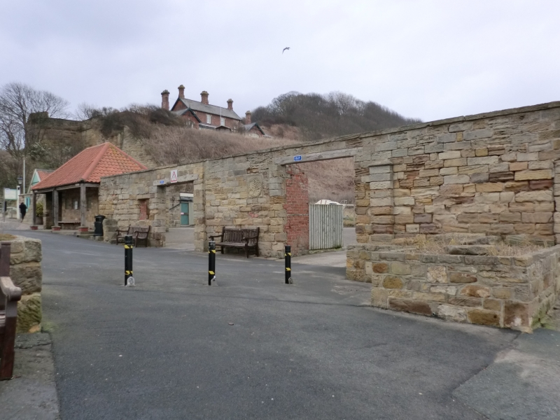
The monument includes the buried and standing remains of an alum house located
on the north side of Sandsend Beck. Most of the monument lies beneath a
car park, although the front wall of the alum house is still standing
across the entrance to the car park.
The standing remains of the alum house comprise a single rubble built wall
pierced by two large entrances. To the rear of the wall, the further remains
of the alum house and associated structures lie beneath the surface of the car
park. A map of 1849 shows the alum works covering the whole area of the
car park. Photographs from the 1920s and a map of 1938 show the buildings
adjacent to the road still standing with the area to the rear an open space.
The site became a car park after World War II and following storm damage to
the sea-wall in the 1960s the coastal defences were rebuilt and the car park
surfaced. It is thus considered that significant remains of the alum works
have remained buried and undisturbed since the closure of the alum house.
The alum house operated from 1733 and processed raw alum liquor produced from
the alum quarries to the north. The liquor was transported through wooden
channels known as liquor troughs directly to the alum house. The alum
production ceased in 1855-60 when the nearby alum quarries closed.
The sea wall lies outside the area of the scheduling. A number of features are
excluded from the scheduling; these are the surface of the car park, ticket
machine, signs, the wooden garages and public toilets, although the ground
beneath these features is included.
MAP EXTRACT
The site of the monument is shown on the attached map extract.
Source: Historic England
Alum is a chemical used principally in the textile industry for fixing dyes.
It is not found in a natural state in Britain but can be manufactured from
some types of shale. During the medieval period in Britain alum was imported,
mostly from Italy. Domestic production began in the north of England in the
early 17th century. The industry flourished in the north for 200 years until
the mid-19th century when it was overtaken by new techniques using shale from
coal mining, whilst after 1880 aluminium sulphate replaced alum for most
industrial purposes. The last English aluminium works (at Goole) closed in
1950. Approximately 50 alum sites have been identified in England. Most were
along the Cleveland and Yorkshire coast. Other early sites are known on the
south coast, particularly in Dorset and Hampshire.
Alum works comprise two main monument types: the quarry where extraction and
initial processing took place, and the alum house where final processing took
place. Alum shale was extracted from quarries sited on steep inland hillsides
or coastal cliffs. Initial processing on the quarry floor consisted of
calcination by burning shale in clamps, and the production in settling pits of
alum liquor. The liquor was transported to processing works in sealed casks or
through wooden channels known as liquor troughs. Larger quarries possessed
inclines and haulage gear and sometimes harbour facilities. Stores, workshops
and laboratories can also survive. Evidence of secondary industries such as
epsom salts and iron silicates production is also preserved at alum works.
The alum industry was the first chemical industry in Britain. Its quarries and
works illustrate the early stages of the industry and the technological
advances through the period known as the Industrial Revolution. The alum
industry also offers important information about wider changes in social and
economic conditions during this period. The large scale of the industry's
workings also mean that its remains are today a major component of coastal
landscapes. A sample of the better preserved sites, illustrating the regional,
chronological and technological range of this class of monument, is considered
to merit protection.
The alum house at Sandsend preserves important evidence of alum processing,
and offers scope for the study of the development of the alum industry.
Source: Historic England
Other
Cranstone D, Alum industry step 3 report,
Sandsend 1925, (1925)
Source: Historic England
Other nearby scheduled monuments