Approximate Location Map
Large Map »
This site is entirely user-supported. See how you can help.
Latitude: 54.4937 / 54°29'37"N
Longitude: -0.7057 / 0°42'20"W
OS Eastings: 483933.383983
OS Northings: 511697.395765
OS Grid: NZ839116
Mapcode National: GBR RJJG.0X
Mapcode Global: WHG9X.497X
Entry Name: Old Mulgrave Castle: an enclosure castle incorporated into an 18th century planned landscape
Scheduled Date: 30 November 1925
Last Amended: 4 September 1996
Source: Historic England
Source ID: 1015113
English Heritage Legacy ID: 20535
County: North Yorkshire
Civil Parish: Lythe
Traditional County: Yorkshire
Lieutenancy Area (Ceremonial County): North Yorkshire
Church of England Parish: Lythe with Sandsend
Church of England Diocese: York
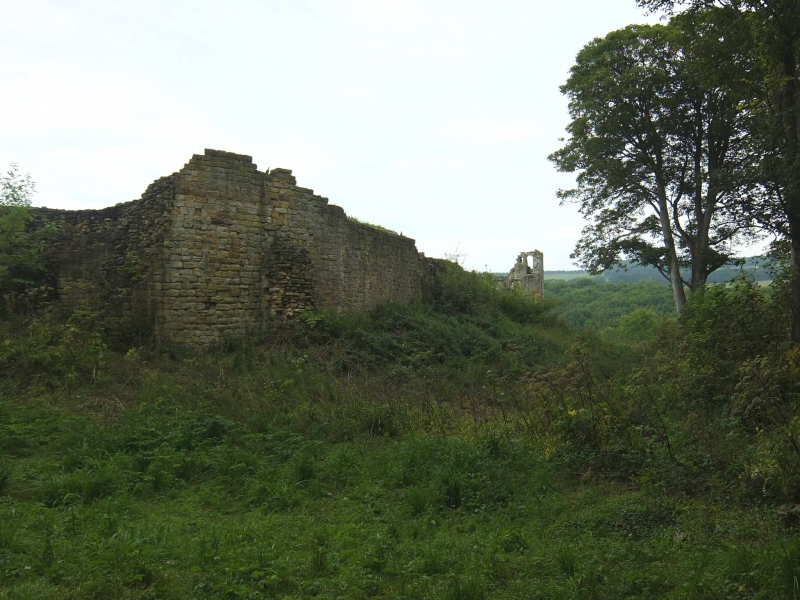
The monument includes a medieval enclosure castle which was at least partly
occupied until the beginning of the 17th century; in the 18th century the
ruins were used as the central feature of a planned landscape designed by
Humphry Repton in the grounds of New Mulgrave Castle. Old Mulgrave Castle (a
Grade I Listed Building) lies at the top of a steep-sided, narrow ridge with
the valley of Sandsend Beck to the north and the valley of East Row to the
south. The castle is constructed at a point where the ridge broadens out and
its curtain walls are cut into the hillside, retaining a terraced platform
which is polygonal in plan, measuring 90m east-west by 70m north-south. The
interior ground level of the castle is up to 7.2m higher than that of the
exterior and over the years numerous buttresses have been added to the curtain
walls in order to reinforce them against outward collapse; at the north
eastern corner these measures proved ineffective and a 30m stretch of the
curtain has fallen away. A 10m wide moat surrounds the castle on its eastern,
southern, and western sides, although it has been altered in several places to
conform to later landscape schemes. A later trackway ramps down into the moat
from the east, runs along the bottom of the moat around the south western
perimeter of the castle before continuing westwards; a bank, 5m wide and 1.5m
high, is visible on the southern edge of the trackway and is a remnant of the
outer bank of the castle moat. The eastern arm of the moat survives as a
ditch, 14m wide and 4m deep, but the northern end of this ditch has been
altered by the addition of a causeway and a stone-lined pond. To the north of
the castle on lower slopes an unusual bank between 1.2m and 1.8m high appears
to be an outwork of the defences, although it has little or no real defensive
qualities. The main gateway lies on the western side of the castle and is
flanked by a pair of cylindrical towers; although the northern tower has
collapsed, the southern tower survives to a height of 4.6m. A steep flight of
stone steps leading down from the gateway, to the track at the bottom of the
moat is a later addition. Opposite the gateway, the side of the moat is
revetted with a 1.4m high stone wall which is the abutment of a drawbridge or
footings of a defensive outwork.
Beyond the gateway, a hollow way runs westward along the spine of the ridge
for a distance of 100m; this hollow way is cut by the present trackway at its
western end and indicates an earlier route leading to the castle across the
drawbridge. An original postern gate may have been located at the north
eastern corner of the castle where the later causeway crosses the moat. The
most prominent structure within the castle enclosure is the central keep which
is square in plan, with four cylindrical corner towers and survives to a
height of about 5m; the 16th century mullioned windows are later alterations
to the structure, which originally dates to around AD 1300. Although other
internal buildings have been demolished, their foundations are visible as low
earthworks and, in the 1900s, part excavations by the Marquis of Normanby
revealed that most of the interior retained below ground remains of buildings.
Some of the Marquis' excavation trenches were not infilled and are still
visible, especially to the north of the keep.
Old Mulgrave Castle was founded by Robert de Turnham, in about 1200, as the
successor to an earlier motte and bailey castle, founded by Nigel Fossard,
which lies 700m to the west. Although the castle was mentioned as `ruinous' in
1309, the keep was certainly occupied in the 16th century when its mullioned
windows were inserted. The old castle was still of sufficient strategic
importance to warrant its assault and part demolition in 1647, during the
Civil War. The present house known as Mulgrave Castle was built in 1735 on a
new site 1km to the north east and, in 1792, the landscape gardener, Humphry
Repton, was appointed to draw up a series of proposals for laying out the
environs of the house; the original `Red Book' containing his designs survives
and it recorded that he saw the potential of incorporating the ruins of the
Old Castle into his landscape. Some alteration of the medieval structure, as
noted above, will have been undertaken at that time, although Repton states
that such interference was to be kept to a minimum. Photographs taken during
the early 20th century show that the interior of the castle was still
maintained as well tended grassland with benches laid out around the walls,
showing that the ruins continued to be used for recreation.
MAP EXTRACT
The site of the monument is shown on the attached map extract.
It includes a 2 metre boundary around the archaeological features,
considered to be essential for the monument's support and preservation.
Source: Historic England
An enclosure castle is a defended residence or stronghold, built mainly of
stone, in which the principal or sole defence comprises the walls and towers
bounding the site. Some form of keep may have stood within the enclosure but
this was not significant in defensive terms and served mainly to provide
accommodation. Larger sites might have more than one line of walling and there
are normally mural towers and gatehouses. Outside the walls a ditch, either
waterfilled or dry, crossed by bridges may be found. The first enclosure
castles were constructed at the time of the Norman Conquest. However, they
developed considerably in form during the 12th century when defensive
experience gained during the Crusades was applied to their design. The
majority of examples were constructed in the 13th century although a few were
built as late as the 14th century. Some represent reconstructions of earlier
medieval earthwork castles of the motte and bailey type, although others were
new creations. They provided strongly defended residences for the king or
leading families and occur in both urban and rural situations. Enclosure
castles are widely dispersed throughout England, with a slight concentration
in Kent and Sussex supporting a vulnerable coast, and a strong concentration
along the Welsh border where some of the best examples were built under Edward
I. They are rare nationally with only 126 recorded examples. Considerable
diversity of form is exhibited with no two examples being exactly alike. With
other castle types, they are major medieval monument types which, belonging to
the highest levels of society, frequently acted as major administrative
centres and formed the foci for developing settlement patterns. Castles
generally provide an emotive and evocative link to the past and can provide a
valuable educational resource, both with respect to medieval warfare and
defence and with respect to wider aspects of medieval society. All examples
retaining significant remains of medieval date are considered to be nationally
important.
Despite inherent structural weakness of the medieval structure, the curtain
walls survive to a height of several metres in places, while the keep survives
as a standing structure and the foundations of other internal buildings
survive below ground. Unusually, Old Mulgrave Castle was constructed on a new
site, away from that of its Norman predecessor. Because the archaeological
remains of the earlier stronghold have not been disturbed by later
construction, the two monuments considered together offer a relatively rare
opportunity for studying the development of medieval fortifications over time.
Subsequently the castle was incorporated as a romantic ruin into one of
Humphry Repton's most important landscape gardens. The gardens are themselves
graded II* and are considered to be of great historic interest.
Source: Historic England
Books and journals
Mulgrave Castle, (1990)
Cathcart-King, D J, Castellarium Anglicanum, (1983)
Page, W, The Victoria History of the County of North Riding of Yorkshire, (1912)
Other
Record No. 07405.0000,
Source: Historic England
Other nearby scheduled monuments