Approximate Location Map
Large Map »
This site is entirely user-supported. See how you can help.
Latitude: 54.4877 / 54°29'15"N
Longitude: -0.9695 / 0°58'10"W
OS Eastings: 466854.014529
OS Northings: 510754.137999
OS Grid: NZ668107
Mapcode National: GBR PJNK.X1
Mapcode Global: WHF8N.2GLH
Entry Name: Sand Hill round cairn, 90m south of Coldman Hargos boundary stone
Scheduled Date: 3 November 1970
Last Amended: 9 May 2001
Source: Historic England
Source ID: 1020038
English Heritage Legacy ID: 30165
County: North Yorkshire
Civil Parish: Commondale
Traditional County: Yorkshire
Lieutenancy Area (Ceremonial County): North Yorkshire
Church of England Parish: Danby with Castleton and Commondale
Church of England Diocese: York
The monument includes the buried and earthwork remains of a prehistoric burial
mound, located on the line of the old Commondale-Danby parish boundary, 600m
north east of the centre of Commondale.
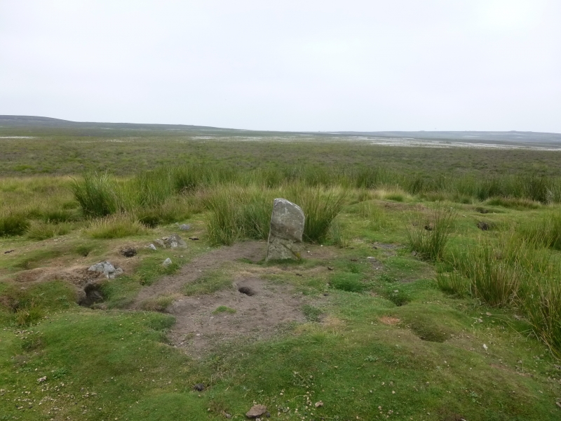
Sand Hill round cairn survives as a 16m diameter stone and sandy earth mound
up to 0.7m high. On its western flank there are two exposed kerb stones, and
there is evidence for further concealed kerb stones around the rest of the
circuit. At the centre of the cairn there is a 0.3m by 0.2m standing stone
rising 0.8m above the top of the mound. This was formerly used as a parish
boundary stone. The monument is sited on a level area of ground some 200m to
the north and west of the top of the scarp above the River Esk.
Excavations of other barrows has shown that even where no encircling
depression is discernible on the modern ground surface, ditches immediately
around the outside of cairns frequently survive as infilled features,
containing additional archaeological deposits.
MAP EXTRACT
The site of the monument is shown on the attached map extract.
It includes a 2 metre boundary around the archaeological features,
considered to be essential for the monument's support and preservation.
Source: Historic England
Round cairns are prehistoric funerary monuments dating to the Bronze Age
(c.2000-700 BC). They were constructed as stone mounds covering single or
multiple burials. These burials may be placed within the mound in stone-lined
compartments called cists. In some cases the cairn was surrounded by a ditch.
Often occupying prominent locations, cairns are a major visual element in the
modern landscape. They are a relatively common feature of the uplands and are
the stone equivalent of the earthen round barrows of the lowlands. Their
considerable variation in form and longevity as a monument type provide
important information on the diversity of beliefs and social organisation
amongst early prehistoric communities. They are particularly representative of
their period and a substantial proportion of surviving examples are considered
worthy of protection.
Excavations of round cairns and barrows in the region have shown that they
demonstrate a very wide range of burial rites from simple scatters of cremated
material to coffin inhumations and cremations contained in urns, typically
dating to the Bronze Age. A common factor is that they were normally used for
more than one burial and that the primary burial was frequently on or below
the original ground surface, often with secondary burials located within the
body of the mound. Most include a small number of grave goods. These are often
small pottery food vessels, but stone, bone, jet and bronze items have also
occasionally been found. In the Bronze Age, many round cairns are thought to
have acted as territorial markers in addition to their role as burial sites.
Sand Hill round cairn, sited on the south western edge of Brown Hill, is
considered to be one such example.
Source: Historic England
Other nearby scheduled monuments