Approximate Location Map
Large Map »
This site is entirely user-supported. See how you can help.
Latitude: 54.4855 / 54°29'7"N
Longitude: -0.95 / 0°57'0"W
OS Eastings: 468119.653622
OS Northings: 510521.4918
OS Grid: NZ681105
Mapcode National: GBR PJTK.3V
Mapcode Global: WHF8N.CJV6
Entry Name: Round barrow on Three Howes Rigg, 310m south east of White Cross
Scheduled Date: 17 March 1964
Last Amended: 4 February 1999
Source: Historic England
Source ID: 1018766
English Heritage Legacy ID: 30172
County: North Yorkshire
Civil Parish: Commondale
Traditional County: Yorkshire
Lieutenancy Area (Ceremonial County): North Yorkshire
Church of England Parish: Danby with Castleton and Commondale
Church of England Diocese: York
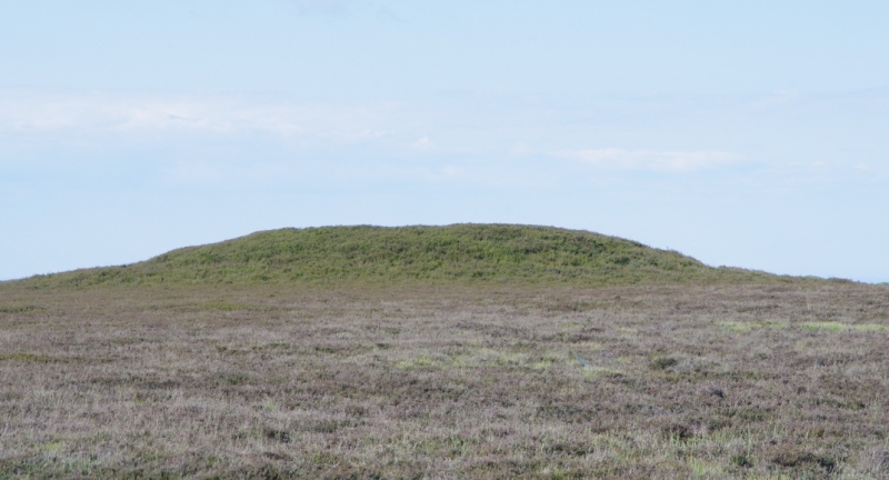
The monument includes the buried and earthwork remains of the northernmost of
a line of five prehistoric burial mounds, the other four of which are the
subject of separate schedulings. The five barrows are all located on the top
of the broad ridge which forms the Rigg to the south of White Cross. The
northernmost barrow and the southern pair centred 270m to the south all lie
in an approximate north-south line with the remaining two barrows sited 25m-
30m to the east of this line, 150m and 200m to the south.
The northernmost barrow is the largest and most prominent of the group. It
survives as a mound 21m in diameter standing 1.8m high on level ground. The
side of the mound has a step or berm 0.4m above the surrounding ground surface
all around the mound except for the southern side. This berm is at its widest
on the northern side where it is 3m wide. On the top of the mound there is a
0.5m deep depression 3m in diameter at the base and 5m in diameter at the top.
Excavations of other barrows has shown that shallow ditches immediately
encircling the mounds are common, normally surviving as infilled features
rather than as earthworks.
MAP EXTRACT
The site of the monument is shown on the attached map extract.
It includes a 2 metre boundary around the archaeological features,
considered to be essential for the monument's support and preservation.
Source: Historic England
Bowl barrows, the most numerous form of round barrow, are funerary monuments
dating from the Late Neolithic period to the Late Bronze Age, with most
examples belonging to the period 2400-1500 BC. They were constructed as
earthen or rubble mounds, sometimes ditched, which covered single or multiple
burials. They occur either in isolation or grouped as cemeteries and often
acted as a focus for burials in later periods. Often superficially similar,
although differing widely in size, they exhibit regional variations in form
and a diversity of burial practices. There are over 10,000 surviving bowl
barrows recorded nationally (many more have already been destroyed), occurring
across most of lowland Britain. Often occupying prominent locations, they are
a major historic element in the modern landscape and their considerable
variation of form and longevity as a monument type provide important
information on the diversity of beliefs and social organisations amongst early
prehistoric communities. They are particularly representative of their period
and a substantial proportion of surviving examples are considered worthy of
protection.
Excavations of round barrows in the region have shown that they demonstrate a
very wide range of burial rites from simple scatters of cremated material to
coffin inhumations and cremations contained in urns, typically dating to the
Bronze Age. A common factor is that barrows were normally used for more than
one burial and that the primary burial was frequently on or below the original
ground surface, often with secondary burials located within the body of the
mound. Most barrows include a small number of grave goods. These are often
small pottery food vessels, but stone, bone, jet and bronze items have also
occasionally been found.
The barrow 310m south east of White Cross on Three Howes Rigg is one of an
important group of barrows. It is relatively well preserved and forms a local
landmark. The surrounding berm is a rare feature for a barrow on the moors,
and confers additional importance to the monument.
Source: Historic England
Books and journals
Smith, M J B, Excavated Bronze Age Burial Mounds of Durham and N' land., (1994)
Source: Historic England
Other nearby scheduled monuments