Approximate Location Map
Large Map »
This site is entirely user-supported. See how you can help.
Latitude: 54.4878 / 54°29'16"N
Longitude: -0.9528 / 0°57'9"W
OS Eastings: 467937.954014
OS Northings: 510779.666264
OS Grid: NZ679107
Mapcode National: GBR PJSK.J0
Mapcode Global: WHF8N.BGJF
Entry Name: White Cross wayside cross at the junction of the roads to Castleton and Commondale
Scheduled Date: 17 March 1964
Last Amended: 17 July 1995
Source: Historic England
Source ID: 1012893
English Heritage Legacy ID: 25642
County: North Yorkshire
Civil Parish: Commondale
Traditional County: Yorkshire
Lieutenancy Area (Ceremonial County): North Yorkshire
Church of England Parish: Danby with Castleton and Commondale
Church of England Diocese: York
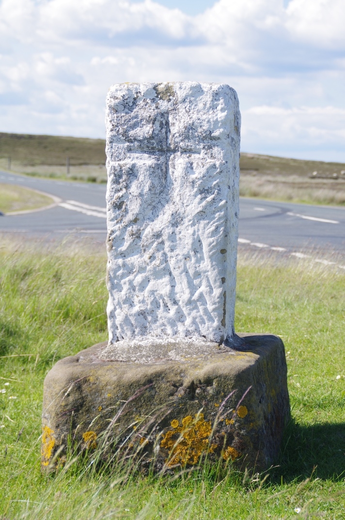
The monument includes a wayside cross, Listed Grade II, on the south west side
of the junction of the road from Castleton northwards and the turn off to
Commondale to the west. The cross consists of a medieval cross base and a
later broken shaft set into the socket.
White Cross survives as a base of local fine gritstone measuring 0.62m by
0.62m at the ground level tapering slightly to 0.57m by 0.56m. The base is
0.36m high. The shaft is of local gritstone 0.8m high and 0.37m by 0.27m at
the socket tapering to 0.31m by 0.24m at the top. The shaft is dressed in a
chevron pattern indicating a post medieval date probably in the 19th century.
The base is dateable to the medieval period. The east face of the base has the
inscription - White Cross.
Each face of the shaft is carved with a simple cross with equal arms 0.22m
across. The east face has an OS bench mark cut near the ground. The cross has
been whitewashed over the years according to the practice of the Downe Estate.
The cross stands in its original position 2m from the edge of the old route
from Castleton across Danby Low Moor. It also acts as a boundary marker for
the medieval parishes of Danby and Commondale and now the county constituency
of Cleveland and Whitby. The original shaft for this cross is in a museum at
Whitby.
The road edge is excluded from the scheduling but the ground beneath it is
included.
MAP EXTRACT
The site of the monument is shown on the attached map extract.
It includes a 2 metre boundary around the archaeological features,
considered to be essential for the monument's support and preservation.
Source: Historic England
Wayside crosses are one of several types of Christian cross erected during the
medieval period, mostly from the 9th to 15th centuries AD. In addition to
serving the function of reiterating and reinforcing the Christian faith
amongst those who passed the cross and of reassuring the traveller, wayside
crosses often fulfilled a role as waymarkers, especially in difficult and
otherwise unmarked terrain. The crosses might be on regularly used routes
linking ordinary settlements or on routes having a more specifically religious
function, including those providing access to religious sites for parishioners
and funeral processions, or marking long-distance routes frequented on
pilgrimages.
Over 350 wayside crosses are known nationally, concentrated in south west
England throughout Cornwall and on Dartmoor where they form the commonest type
of stone cross. A small group also occurs on the North York Moors. Relatively
few examples have been recorded elsewhere and these are generally confined to
remote moorland locations.
Outside Cornwall almost all wayside crosses take the form of a `Latin' cross,
in which the cross-head itself is shaped within the projecting arms of an
unenclosed cross. In Cornwall wayside crosses vary considerably in form and
decoration. The commonest type includes a round, or `wheel', head on the faces
of which various forms of cross or related designs were carved in relief or
incised, the spaces between the cross arms possibly pierced. The design was
sometimes supplemented with a relief figure of Christ and the shaft might bear
decorative panels and motifs. Less common forms in Cornwall include the
`Latin' cross and, much rarer, the simple slab with a low relief cross on both
faces. Rare examples of wheel-head and slab-form crosses also occur within the
North York Moors group. Most wayside crosses have either a simple socketed
base or show no evidence for a separate base at all.
Wayside crosses contribute significantly to our understanding of medieval
religious customs and sculptural traditions and to our knowledge of medieval
routeways and settlement patterns. All wayside crosses which survive as earth-
fast monuments, except those which are extremely damaged and removed from
their original locations, are considered worthy of protection.
The cross known as White Cross survives well in spite of the removal of its
original shaft. It is in its proper location marking the junction of two old
routes: the one from Castleton linking Rosedale with Lingdale and the other
from Commondale to this main route. It also marks the boundaries of two
medieval parishes: Danby and Commondale.
Source: Historic England
Books and journals
Graham, L, The Crosses of the North Yorkshire Moors, (1993), 32
Woodwark, T H, Crosses of the North York Moors, (1923), 27
Source: Historic England
Other nearby scheduled monuments