Approximate Location Map
Large Map »
This site is entirely user-supported. See how you can help.
Latitude: 50.6093 / 50°36'33"N
Longitude: -4.7033 / 4°42'11"W
OS Eastings: 208825.836
OS Northings: 82328.4765
OS Grid: SX088823
Mapcode National: GBR N3.BXB3
Mapcode Global: FRA 171G.7JB
Entry Name: Three wayside crosses in St Julitta's churchyard
Scheduled Date: 9 October 1981
Last Amended: 24 July 1998
Source: Historic England
Source ID: 1018208
English Heritage Legacy ID: 30449
County: Cornwall
Civil Parish: Camelford
Traditional County: Cornwall
Lieutenancy Area (Ceremonial County): Cornwall
Church of England Parish: Lanteglos by Camelford
Church of England Diocese: Truro
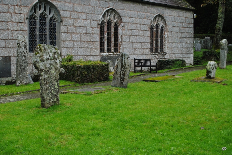
The monument includes three medieval wayside crosses situated to the south of
the church in St Julitta's churchyard, Lanteglos.
One wayside cross, the Rectory cross head, is located on the north side of the
footpath through the churchyard; the other two, the Trewalder Cross and the
Rectory Cross are on the south side of this footpath.
The Rectory cross-head survives as a round `wheel' head set on a modern
granite base. The overall height of the monument is 0.74m. The principal faces
are orientated north-south. The head measures 0.62m in diameter and is 0.1m
thick. Both principal faces bear a relief equal limbed cross with expanded
ends to the limbs, with a narrow bead around the outer edge of the head. There
is a central rounded projection or boss at the intersection of the limbs of
the cross motif, and another four rounded bosses, one in the space between
each limb of the cross motif. Immediately below the head, at the neck are two
small rounded projections, one on either side of the shaft. The short section
of shaft is cemented into a granite boulder. This base measures 1.19m
east-west by 0.82m north-south and is 0.12m high. This cross was first
recorded on a rocky island in a fishpond at Lanteglos Rectory. In 1877 it was
mounted on top of the Castle Goff early Christian memorial stone, which was
also in the Rectory grounds and is the subject of a separate scheduling. Some
time later it was removed from the memorial stone and moved into the
churchyard. In 1997 the cross was mounted on a new base.
The Trewalder Cross is located on the south side of the footpath opposite the
Rectory cross-head. It survives as an upright granite shaft with a round
`wheel' head mounted in a rectangular base. The overall height of the cross is
0.75m. The head measures 0.47m wide by 0.28m thick. The principal faces are
orientated north-south and both bear a relief equal limbed cross with expanded
ends to the limbs. The shaft measures 0.29m wide by 0.26m thick and is mounted
on a granite base. The base measures 1.24m east-west by 1.13m north-south and
is 0.10m high. This cross was found at Trewalder, 1.5km to the west of
Lanteglos church. It stood on a hedge at a corner of a field, and was moved to
the opposite hedge when the road was widened. In 1912 it was moved into the
churchyard.
The Rectory Cross on the south side of the foot-path survives as an upright
granite shaft with a round `wheel' head; its overall height is 1.55m. The head
measures 0.52m wide and 0.23m thick. The principal faces are orientated north-
south and both bear a relief equal limbed cross, a narrow bead running around
the outer edge of the head. The shaft measures 0.4m wide by 0.25m thick. This
cross was first recorded in 1858 in the Rectory gardens, It was stated that
the cross had been removed from the highway, probably the A39, a major ancient
and modern route into Cornwall from the east.
The metalled surface of the footpath between the crosses, the flat gravestone
to the north of the Trewalder Cross, the chest tomb to the south of the
Rectory Cross, the chest tomb to the the west, the wooden bench on its
concrete base to the east, and the cement gutter or drain to the north of the
Rectory cross-head, where they fall within the monument's protective margin,
are excluded from the scheduling but the ground beneath is included.
MAP EXTRACT
The site of the monument is shown on the attached map extract.
Source: Historic England
Wayside crosses are one of several types of Christian cross erected during the
medieval period, mostly from the 9th to 15th centuries AD. In addition to
serving the function of reiterating and reinforcing the Christian faith
amongst those who passed the cross and of reassuring the traveller, wayside
crosses often fulfilled a role as waymarkers, especially in difficult and
otherwise unmarked terrain. The crosses might be on regularly used routes
linking ordinary settlements or on routes having a more specifically religious
function, including those providing access to religious sites for parishioners
and funeral processions, or marking long-distance routes frequented on
pilgrimages.
Over 350 wayside crosses are known nationally, concentrated in south west
England throughout Cornwall and on Dartmoor where they form the commonest type
of stone cross. A small group also occurs on the North York Moors. Relatively
few examples have been recorded elsewhere and these are generally confined to
remote moorland locations.
Outside Cornwall almost all wayside crosses take the form of a `Latin' cross,
in which the cross-head itself is shaped within the projecting arms of an
unenclosed cross. In Cornwall wayside crosses vary considerably in form and
decoration. The commonest type includes a round, or `wheel', head on the faces
of which various forms of cross or related designs were carved in relief or
incised, the spaces between the cross arms possibly pierced. The design was
sometimes supplemented with a relief figure of Christ and the shaft might bear
decorative panels and motifs. Less common forms in Cornwall include the
`Latin' cross and, much rarer, the simple slab with a low relief cross on both
faces. Rare examples of wheel-head and slab-form crosses also occur within the
North York Moors group. Most wayside crosses have either a simple socketed
base or show no evidence for a separate base at all.
Wayside crosses contribute significantly to our understanding of medieval
religious customs and sculptural traditions and to our knowledge of medieval
routeways and settlement patterns. All wayside crosses which survive as earth-
fast monuments, except those which are extremely damaged and removed from
their original locations, are considered worthy of protection.
The three medieval wayside crosses in St Julitta's churchyard survive well.
The original location of the Trewalder Cross is recorded, possibly having
marked a route within the parish to the church. The Rectory Cross probably
also marked a major route through Cornwall. The Rectory cross-head bears
unusual decoration with the five bosses, sometimes found on churchyard
crosses. Both this cross and the Trewalder Cross have projections at the neck,
a rare feature found on some crosses in north Cornwall. Their removal into the
churchyard and re-erection there early in the 20th century demonstrates well
the changing attitudes to religion and their impact on the local landscape
since the medieval period.
Source: Historic England
Books and journals
Langdon, A G, Old Cornish Crosses, (1896)
Langdon, A G, Old Cornish Crosses, (1896)
Langdon, A G, Old Cornish Crosses, (1896)
Langdon, A G, Stone Crosses in East Cornwall, (1996)
Langdon, A G, Stone Crosses in East Cornwall, (1996)
Langdon, A G, Stone Crosses in East Cornwall, (1996)
Preston-Jones, A, Attwell, D, The Rectory Cross-head at Lanteglos by Camelford, (1997)
Other
Title: 1:25000 Ordnance Survey Map; SX 08/18: Pathfinder Series 1325
Source Date: 1986
Author:
Publisher:
Surveyor:
Source: Historic England
Other nearby scheduled monuments