Approximate Location Map
Large Map »
This site is entirely user-supported. See how you can help.
Latitude: 50.6189 / 50°37'8"N
Longitude: -4.6911 / 4°41'28"W
OS Eastings: 209725.782081
OS Northings: 83366.56222
OS Grid: SX097833
Mapcode National: GBR N4.B6V4
Mapcode Global: FRA 172F.L7T
Entry Name: Wayside cross at Trevia Walls
Scheduled Date: 22 March 1932
Source: Historic England
Source ID: 1006648
English Heritage Legacy ID: CO 224
County: Cornwall
Civil Parish: Camelford
Traditional County: Cornwall
Lieutenancy Area (Ceremonial County): Cornwall
Church of England Parish: Lanteglos by Camelford
Church of England Diocese: Truro
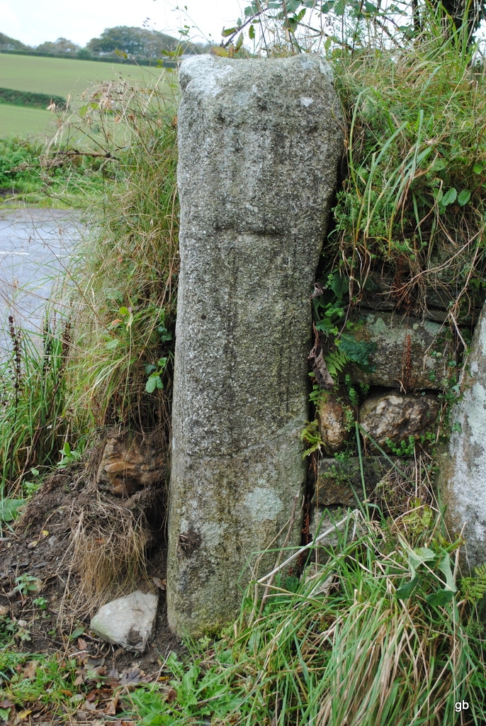
The monument includes a wayside cross, situated to the north of a road junction known as Trevia Walls, marking routes between the settlements of Trevia, Hendra and Camelford. The cross survives as a decorated wheel-head on a repaired length of shaft set into a roadside hedge. The cross is approximately 1.6m high. The head is decorated with a Latin cross in relief within a horseshoe-shaped recess on both faces, and there is a shield-shaped incised carving on one face of the shaft.
The cross was in use as a gatepost until the 1980's when the gate was widened and it remained built into the hedge. It is no longer in use as a gatepost, thus ensuring its protection. The cross was described by Langdon in 1896, and he suggested it had once stood in the centre of the junction, although it was in use as a gatepost when he first recorded it. It has also been suggested that the incised shield may be related to its use as a boundary marker.
Sources: HER:-
PastScape Monument No:-431995
Source: Historic England
Wayside crosses are one of several types of Christian cross erected during the medieval period, mostly from the 9th to 15th centuries AD. In addition to serving the function of reiterating and reinforcing the Christian faith amongst those who passed the cross and of reassuring the traveller, wayside crosses often fulfilled a role as waymarkers, especially in difficult and otherwise unmarked terrain. The crosses might be on regularly used routes linking ordinary settlements or on routes which might have a more specifically religious function, including providing access to religious sites for parishioners and funeral processions. Wayside crosses vary considerably in form and decoration but several regional types have been identified. The Cornish wayside crosses form one such group. The commonest type includes a round, or `wheel', head on the faces of which various forms of cross were carved. The design was sometimes supplemented with a relief figure of Christ. Less common forms include the `Latin' cross, where the cross-head itself is shaped within the arms of an unenclosed cross and, much rarer, the simple slab with a low-relief cross on both faces. Over 400 crosses of all types are recorded in Cornwall. Wayside crosses contribute significantly to our understanding of medieval routeways, settlement patterns and the development of sculptural traditions and their survival is somewhat differential because of periods of religious turbulence during the Reformation when many were subject to damage or partial destruction by iconoclasts. Despite having been moved from its original location and its use as a gatepost, the wayside cross at Trevia Walls survives comparatively well and serves to indicate the turbulent history such features of the landscape have endured through time. It remains close to its original location marking an important route between settlements and, despite a somewhat chequered history, still retains much of its original carving and bears witness to several phases of active re-use.
Source: Historic England
Other nearby scheduled monuments