Approximate Location Map
Large Map »
This site is entirely user-supported. See how you can help.
Latitude: 54.488 / 54°29'16"N
Longitude: -0.6075 / 0°36'26"W
OS Eastings: 490304.011392
OS Northings: 511186.661672
OS Grid: NZ903111
Mapcode National: GBR SJ6J.8Y
Mapcode Global: WHG9Y.MGX8
Entry Name: Whitby Abbey: Saxon double-house, post-Conquest Benedictine monastery, C17 manor house and C14 cross.
Scheduled Date: 19 April 1915
Last Amended: 9 June 1992
Source: Historic England
Source ID: 1017941
English Heritage Legacy ID: 13284
County: North Yorkshire
Civil Parish: Whitby
Built-Up Area: Whitby
Traditional County: Yorkshire
Lieutenancy Area (Ceremonial County): North Yorkshire
Church of England Parish: Whitby St Mary
Church of England Diocese: York
Whitby Abbey is situated in a prominent position on East Cliff, above the
fishing port of Whitby and overlooking the North Sea. The monument is a
multi-period site comprising a single constraint area containing a number of
features. These include the buried remains of the seventh century monastery
of Streonaeshalh and the eleventh century abbey church, the ruins of the later
church and associated features of the post-Conquest Benedictine monastery, the
ruins of a seventeenth century manor house of the Cholmley family and a
fourteenth century cross, situated on Abbey Plain.
Streonaeshalh was the first monastic foundation on the site and, typically of
the early Anglo-Saxon period, was a double-house of both men and women
presided over by an abbess. In 1924-25, partial excavation of the site
carried out by Sir Charles Peers uncovered a small area of the Saxon monastery
on the west and north sides of the medieval church which, from the material
recovered, has been interpreted as part of the women's quarters. At least two
phases of development were represented, the earliest comprising timber
buildings. Elaborate ranges were served by a network of drains and were split
into groups by paths. Four individual cells were identified, each having a
living area with an open hearth and a bedroom with a latrine. Another
building was either a guesthouse or a store and was partially rebuilt when a
new series of rooms was added to its east side. A group of buildings to the
west were found to overlie earlier burials and have been dated to the early
ninth century. Finds were of a domestic sort and included quernstones,
loomweights, needles, pins and writing implements. No clearly communal
chapterhouse, refectory or dormitory was found and the relative scarcity of
Saxon material suggests that the larger part of the Saxon foundation lies
below and to the south of the church, beneath the cloister of the post-
Conquest abbey. Similarly, there is no evidence as yet of the pre-Conquest
abbey church. It is believed that this will be found beneath the naves of the
fourteenth and eleventh century churches.
Peers' excavation also revealed the foundations of the east end and transepts
of the eleventh century church built soon after the foundation of the
Benedictine monastery. He did not excavate the nave but the position of the
mid-twelfth century parlour, which would have marked the junction of the north
and west cloister ranges, suggests it was as long as the fourteenth century
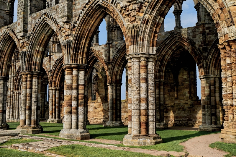
nave which overlies it. The later medieval church, whose ruins are all that
is left standing of the post-Conquest abbey, was begun in c.1220 with the
rebuilding of the east end, followed, over the next few decades, by the
reconstruction of the transepts. The first three bays of the nave were also
rebuilt at this time, along with the central tower. The rest of the nave was
not rebuilt until the fourteenth century, with a clerestory - a row of
windows set above the main storey to let in light - being added in the
fifteenth. The west end is also fifteenth century.
The church would have formed the north range of a four-sided cloister, with
the east, south and west ranges lying to the south. An engraving by Samuel
Buck (1711) shows the late twelfth century chapterhouse occupying its
traditional position in the east range, below the south transept. There are
no visible remains of these ranges but the buried foundations survive
undisturbed and preserve the layout of the post-Conquest monastery. By
analogy with other abbeys, it is believed that the east range would also have
included the dorter (dormitory), the south range the kitchen and frater
(refectory) and the west range rooms for storage and cellarage. Other rooms
and buildings would have included an infirmary, warming-house, guesthouse and
day-rooms whilst, outside the cloister, within the wider precinct, would have
lain a variety of ancillary buildings such as a brewhouse, bakehouse and
gatehouse. Earthworks to the north of the church, on Abbey Plain, may
represent some of these and other earthworks have been located to the west, in
the field known as Almshouse Close. Additional features include cemeteries
and a fishpond, the latter lying to the east of the church. Excavations at
the Saxon monasteries of Jarrow and Monkwearmouth indicate that the cemetery
of the double house lies to the south of the church, beneath the medieval
cloister. The later monastic cemetery, according to tradition, will lie east
or south of the east cloister range. A medieval lay cemetery was discovered
north of the church during Peers' excavations.
To the south-west of the church lay the abbot's lodging which, after the
Dissolution, became part of Abbey House, the residence of the Cholmley family.
Adjacent to the present Abbey House, which is not included in the scheduling,
is the shell of a building known as the Banqueting House. This is part of the
manor house built by the Cholmley family in the 1630s, with the Banqueting
House itself being added in c.1672. Constructed in the late seventeenth
century classical style, it was deserted in 1743 and gutted in c.1790. Prior
to the seventeenth century manor house, a sixteenth century timber manor house
stood on the site and its remains will survive beneath the later buildings.
North of the church on Abbey Plain is a fourteenth century cross on a plinth
of six steps. Although the head is gone, the panelled shaft and capital are
well-preserved.
The Saxon double-house was founded in 657 by King Oswy of Northumbria. It's
first and most illustrious abbess was St. Hild who presided there till her
death in 680 when the abbacy passed to Oswy's daughter Aelfled. Not only was
the abbey a royal burial place, many distinguished Saxon churchmen and women
were educated there, including Caedmon, the most celebrated vernacular poet of
Northumbria. The monastery's greatest claim to fame, however, and an
indication of its reputation at the time, was that it was the setting for the
Synod of Whitby of 664, one of the most important events in the history of
Christianity in England at which it was decided that the English Church would
follow the Roman rite rather than the insular `Celtic' tradition.
Our main written sources for the the Saxon monastery are the histories of the
Venerable Bede. Consequently, little is known about the abbey in the years
following his death except that it was destroyed in 867 by the Viking army led
by the sons of Ragnar Lothbrok. An interval of more than two centuries
followed until, in 1078, William de Percy granted the abbey site to Reinfrid,
an unlettered monk who had come with two companions on a pilgrimage to visit
the holy places of the north. The initial foundation, however, was beset by
trouble, not only from sea-raids but also from arguments with the founder and
internal strife which resulted in a group of monks under one of their number,
Stephen, retiring to Lastingham and, ultimately, St. Mary's in York. The
abbey began to flourish when Serlo de Percy, William's brother, became prior
and when William's son became abbot. Despite occasional raids, the last
occurring in c.1153 under Eystein Haroldsson, King of Norway, the Benedictine
abbey quickly became the third in value after St. Mary's in York and St.
German's in Selby, and it was not until the fourteenth century that it began
to decline.
By then it was heavily in debt and, by the time of its suppression in 1539,
it was a poor house by Benedictine standards though still rich by those of
other Orders. Following the Dissolution, the lease of the abbey and precinct
was given to Richard Cholmley who subsequently bought the freehold in 1555.
It remained with the Cholmley family until 1791 when it passed by marriage to
the Fanes. The medieval church suffered gradual decline,and was damaged by a
direct hit from a German cruiser in 1914. The abbey has been in State care
since 1920 and the Banqueting House since 1935. Both are Grade I Listed, as
is the cross on Abbey Plain. Also Grade I Listed are the almshouses and walls
and gatepiers of Abbey House.
There are a number of features, within the area, to be excluded from the
scheduling. These include all English Heritage fixtures and fittings, the
surfaces of all paths and drives, the surfaces of the road and carpark, the
fixtures and fittings of the carpark, the buildings of Abbey Lodge, the
Almshouses (now the YHA) and Abbey House except for the Banqueting House, all
modern walling and fencing, the site exhibition centre and ticket office, the
television mast and public conveniences on Abbey Plain and the stiles and
waymarks along the coastal cliff path the coastguard houses, St Hilda's
Cottages and the Station House. The ground beneath all these features and
buildings is included in the scheduling.
MAP EXTRACT
The site of the monument is shown on the attached map extract.
Source: Historic England
A pre-Conquest double house is a settlement built before the Norman Conquest
to house a community of religious men and women. Its main buildings were
constructed to provide facilities for worship, accommodation and subsistence.
They included a series of timber halls and perhaps a stone church, all located
within some form of enclosure. Those sites which have been excavated indicate
that no standard layout of buildings was in use. Rather a great diversity
in building form, construction, arrangement and function is evident. The
earliest English double houses were founded in the seventh century when the
idea of such communities spread to Kent from Merovingian Gaul. By the ninth
century most, if not all, had ceased to function, being replaced by the
increasingly popular single sex communities. Pre-Conquest double houses are
a very rare monument class, only 33 examples having been recognised from
documentary sources. Few of these have been studied in any detail and the
exact location of many is as yet unknown. Only 6 sites have been examined by
excavation. The majority of known examples are located in Kent and
Northumbria, although this largely reflects that these areas are well
documented for the early historic period. Other sites are likely to have
existed in less well documented areas of the country. They are one of the
first types of religious community to be established in Anglo-Saxon England
and are therefore of considerable importance for any analysis of the
introduction of Christianity into the country. All examples exhibiting
survival of archaeological remains will therefore be identified as nationally
important.
Whitby was one of the earliest religious houses to be established in Northern
England. Documentary evidence indicates that it played a major and crucial
role in the development of Christianity in Anglo-Saxon England. Extensive
remains of this early foundation are known to survive beneath the present
ground surface and abbey ruins. Subsequently the site became a wealthy
Benedictine monastery the remains of which also survive well either as
upstanding ruins, earthworks or buried features. Additionally the site
preserves remains of activity both pre- and post-dating its religious use,
allowing investigation of its changing use over 1500 years.
Source: Historic England
Books and journals
Buck, S, Whitby Abbey, (1711)
Clapham, A, Whitby Abbey, (1952)
Pevsner, N, The Buildings of England: Yorkshire: The North Riding, (1966), 393
Brewster, T, 'Medieval Archaeology' in Whitby Abbey (Tv Mast site), , Vol. 13, (1969), 283
Charles, , Radford, , 'Archaeologia' in Whitby Abbey, , Vol. 89, (1943)
Cramp, R J, 'The Archaeology of Anglo-Saxon England' in Monastic Sites, (1976), 201-252
Rahtz, P A, 'Yorkshire Archaeological Journal' in Whitby Abbey, (1967), 72-73
Rahtz, P, 'The Archaeology of Anglo-Saxon England' in The Building Plan of the Anglo-Saxon Monastery of Whitby Abbey, (1976), 459-462
Other
Executed 1980s, PIC, Almshouse Close,
Source: Historic England
Other nearby scheduled monuments