Approximate Location Map
Large Map »
This site is entirely user-supported. See how you can help.
Latitude: 51.6272 / 51°37'37"N
Longitude: -3.0961 / 3°5'46"W
OS Eastings: 324222
OS Northings: 192610
OS Grid: ST242926
Mapcode National: GBR J1.8PY6
Mapcode Global: VH7B4.9C2F
Entry Name: Twm-Barlwm Mound and Bailey Castle
Scheduled Date: 15 September 1933
Source: Cadw
Source ID: 2349
Cadw Legacy ID: MM044
Schedule Class: Defence
Category: Motte
Period: Medieval
County: Caerphilly (Caerffili)
Community: Crosskeys
Traditional County: Monmouthshire
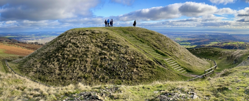
The monument comprises the remains of a motte and bailey castle, a military stronghold built during the medieval period, possibly built on the site of an earlier, Iron Age, hillfort. The motte and bailey occupy a spectacular position on a conical shaped hill at the W end of Mynydd Henllys. The hill slopes steeply on all sides, and there are panoramic views in all directions. The motte is located at the E end of the hilltop. It is steep-sided, 7m high with a flat summit 17m in diameter. On the W side of the motte is a rock-cut ditch, 2.5m deep and 4m wide with near vertical rock faces. On the E and S sides is a shallow ditch, around 1m deep, while on the N side there is no ditch. Extending W from the rock-cut ditch a bank and ditch run around the long oval hilltop enclosing and area of roughly 9 acres. On the S side the bank is 0.4m high on the inside and 3m high on the outside, and the ditch is 1.5m wide and 1.5m deep. Halfway along the S side is a 40m wide gap in the defences, although there are several small lumps in the ditch and on the line of the bank indicating that the rampart could have been disturbed. There are two short, interrupted, sections of bank and ditch around the SW corner, with the foundations of a stone wall on the line of one missing section. There is a short stretch of bank and ditch on the W side and then another large gap. Along the N side the bank and ditch are continuous, except towards the middle of the section where a narrow causeway crosses the ditch and there is a corresponding gap in the bank. The bank and ditch are larger on the N side, with the bank up to 1.5m high on the inside and 4m high on the outside, and the ditch 1.7m deep. The interior of the enclosed area is gently sloping and featureless, with a Trig Point positioned close to the middle. A track runs through the middle of the enclosed area, with newly-built steps leading over the ramparts at the W end.
The monument is of national importance for its potential to enhance our knowledge of medieval defensive organisation and later prehistoric defensive organisation and settlement. The well-preserved monument forms an important element within the wider later prehistoric and medieval context and the structure itself may be expected to contain archaeological information relating to chronology, building techniques and functional detail.
The scheduled area comprises the remains described and areas around them within which related evidence may be expected to survive.
Source: Cadw
Other nearby scheduled monuments