Approximate Location Map
Large Map »
This site is entirely user-supported. See how you can help.
Latitude: 56.5442 / 56°32'39"N
Longitude: -3.1834 / 3°11'0"W
OS Eastings: 327333
OS Northings: 739759
OS Grid: NO273397
Mapcode National: GBR VD.LNFS
Mapcode Global: WH6PQ.2SC0
Entry Name: High Keillor, symbol stone and cairn, 280m NW of
Scheduled Date: 16 November 1923
Last Amended: 7 December 1998
Source: Historic Environment Scotland
Source ID: SM146
Schedule Class: Cultural
Category: Crosses and carved stones: symbol stone; Prehistoric ritual and funerary: cairn (type uncertain)
Location: Kettins
County: Angus
Electoral Ward: Kirriemuir and Dean
Traditional County: Angus
The monument comprises a Pictish symbol stone and a cairn of Pictish or earlier date. The monument was first scheduled in 1923, and rescheduled in 1935, but an inadequate area was included to protect all of the archaeological remains. The present rescheduling is intended to rectify this.
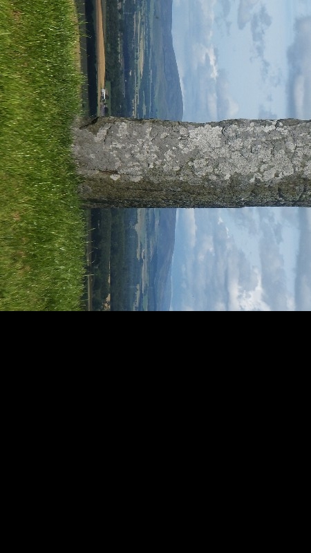
The monument is situated in a stone-walled roadside enclosure at the side of an arable field, at around 140m OD, and commands extensive views across Strathmore. It consists of a cairn measuring approximately 13m in diameter and about 0.7m high, surmounted by a Pictish symbol stone. Early excavations revealed the remains of multiple burials in cists dug into the cairn, and it may be expected that more will remain within and below the cairn.
The stone is set upright in a relatively modern socket-stone at the summit of the cairn, although there is no reason to believe that it has been moved any distance from its original position. It measures some 2m high by about 1.8m in girth. Incised into one of the faces of the stone are a number of Pictish symbols, including a wolf, a 'double-disc and Z-rod', and a double circle.
The symbol stone dates to around the seventh or eighth century AD, while the burial cairn may have been originally constructed as early as the Neolithic period, between around 3000-2000 BC.
The area proposed for scheduling comprises the area within the walled enclosure. It is irregular in shape with maximum dimensions of 38m from its E-most point to its W-most point and 10m transversely. The stone wall is itself excluded from the scheduling.
Source: Historic Environment Scotland
The monument is of national importance because of its potential to contribute to our understanding of Pictish art and prehistoric funerary and ritual practices.
Source: Historic Environment Scotland
Bibliography
The monument is recorded by RCAHMS as NO 23 NE 3.
Source: Historic Environment Scotland
Other nearby scheduled monuments