Approximate Location Map
Large Map »
This site is entirely user-supported. See how you can help.
Latitude: 50.3764 / 50°22'35"N
Longitude: -3.5791 / 3°34'44"W
OS Eastings: 287808.511936
OS Northings: 54137.355339
OS Grid: SX878541
Mapcode National: GBR QS.PQ36
Mapcode Global: FRA 38D1.MFG
Entry Name: D-Day landing craft maintenance site on the River Dart, 270m south east of Maypool Cottage
Scheduled Date: 12 March 2003
Source: Historic England
Source ID: 1020912
English Heritage Legacy ID: 33060
County: Devon
Civil Parish: Kingswear
Traditional County: Devon
Lieutenancy Area (Ceremonial County): Devon
Church of England Parish: Churston Ferrers St Mary the Virgin
Church of England Diocese: Exeter
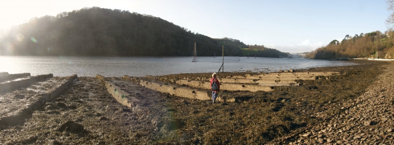
The monument includes a maintenance site built on the east bank of the
River Dart upstream from the port of Dartmouth in South Devon. Its purpose
was to service landing ships during the preparations, engagement, and
aftermath of the 1944 D-Day landings during World War II. The site
includes an arrangement of concrete piers called a `gridiron', a ramped
and raised concrete quay emplacement, and an earthfast concrete mooring
post. Operating from 1943 to 1944 the monument was one of a number of
repair and maintenance sites on the River Dart which were under the
control of the United States Naval Advanced Amphibious Base (USNAAB) at
Dartmouth; these repair sites contributed to the D-Day preparations
codenamed Operation Overlord.
The gridiron was designed to allow flat-bottomed landing craft to be
floated over it sideways at high tide then moored, coming to rest upon it
as the tide fell and enabling inspection, cleaning, and repairs to be
carried out. Overall the gridiron measures a little over 54m in width
north west to south east, and contains 12 parallel straight piers centred
4.85m apart. The piers are just over 30m in length and slope gently down
the intertidal shore to just below Mean Low Water (MLW). The piers, which
are built of shuttered concrete and are embedded in the foreshore shingle
and mud, have a maximum width of about 0.7m. Excavation of a gridiron site
at Mylor in Cornwall suggests that the piers sit upon a concrete raft.
Along the upper edges of each pier are a series of opposed recesses 0.6m
in length by 0.18m wide and 0.12m deep, centred 3.2m apart. These
recesses are believed to have held timber rails formerly laid along the
piers' upper surfaces at right angles to them, and these perhaps prevented
the bottom of the craft's hull from coming into direct contact with the
concrete piers. At a distance of 10m from either end of the gridiron and
about 8m inland from MLW, are two low concrete emplacements both about 4m
long by 2m wide which are considered to be associated mooring posts. Two
timber and steel mooring points (`dolphins') located further into the
river which would have held the craft in place whilst afloat and during
the positioning operation, no longer survive at Maypool.
A further component of the repair facility which does survive is a small
raised quay with an overall length of 23m and a width of 6m. It is
orientated at right angles to the gridiron about 20m further into the
shore at the High Water Mark. Set alongside the low cliff face which forms
the rear of the site, it has a vertical shuttered-concrete wall 1.5m high
which provides a platform just over 11m long by 6m wide. Grooved concrete
settings running parallel with the length of the platform suggest the
original presence of an arched open-ended covering structure which has
since been removed. Forward of the platform was an apron about 3.5m in
length at the head of a sloping ramp 8m in length which formed a slipway.
The quay could have been employed only at high tide and it may have housed
a dinghy or light craft allowing access to the landing craft prior to the
beaching process.
A mooring post emplacement set into the foreshore behind the southern
downstream end of the gridiron comprises the remains of a 0.27 sq m wooden
post embedded in a 2.5 sq m concrete block which stands 0.5m proud of the
surface; the mass of the block is believed to lie below ground level in
order to provide secure purchase. Attached to the mooring post is an iron
chain which itself attaches to a large floatable wooden pontoon which is
lying in a beached position behind the gridiron. The chain and pontoon,
although they may be contemporary with the World War II use of the site,
do not directly relate to the gridiron, and are not part of the
scheduling.
The maintenance site was one of several such sites on the River Dart of
which only three now remain in anything like their original form. It was
constructed by the USNAAB Dartmouth which was commissioned for
preparations for the D-Day invasion of 6th June 1944 and it was part of
the range of shore-base and supply facilities constructed before and
during the invasion. After D-Day the importance of USNAAB Dartmouth as a
base began to wane and the facilities were handed back to the British
before the end of 1944.
A floatable wooden pontoon and the iron chain which attaches it to a
wooden mooring post are excluded from the scheduling, although the post
and the ground beneath the chain and pontoon are included.
MAP EXTRACT
The site of the monument is shown on the attached map extract.
Source: Historic England
D-Day, June 6th 1944, is one of the most significant dates in modern history,
defining the start of the final phase of World War II in Europe. After 2-3
years of preparations, the assault phase of `Operation Overlord' - codenamed
Neptune - lasted for little over three weeks and by 30 June had landed over
850,000 men on the invasion beachheads, together with nearly 150,000 vehicles
and 570,000 tons of supplies.
Sites used for the building, maintenance and repair of landing craft and
landing ships were essential to developing and retaining a fleet capable of
delivering Prime Minister Churchill's `great plan'. With so many vessels
involved (landing craft and landing ships principally, but there were 46
different types in all), construction and maintenance were significant tasks.
Contemporary descriptions refer to unprecedented levels of maritime activity,
with every port, harbour and boatyard being involved, in addition to beaches
and the streets of coastal towns and villages. The more substantial sites were
either in largely unmodified dry docks or on specially built `gridirons' or
slipways. The gridirons were used for maintenance, and took the form of a
series of parallel concrete slipways running down a slight gradient into the
water, allowing the boat to be floated on at high tide and repaired at low
tide; some were supplied with a winch mechanism for pulling vessels onto the
grid, and steel mooring points (`dolphins') for securing them when afloat.
Recorded examples include sites on the Rivers Dart (Devon), Tamar and Fal
(Cornwall), and in Portsmouth Harbour. Slipways, with a metal rail, winch
mechanisms and dolphins, used for landing ship repairs, are recorded on the
River Dart. However, much construction, repair and maintenance work was
conducted on an ad hoc arrangement and leaves little trace: for example,
landing craft (assault) - LCAs - were small vessels constructed and repaired
mainly in back streets and improvised hards at the water's edge.
Although in military archaeology fixed defences will often survive better than
materiel representing the mobile offensive, sufficient of the preparations for
D-Day in England remains to give an impression of the scale of the Operation,
and the variety of the specific tasks involved. All sites where surviving
remains provide an impression of the scale and nature of the preparations for
D-Day will be considered of national importance.
The D-Day landing craft maintenance site on the River Dart, 270m south
east of Maypool Cottage survives well with the gridiron retaining all
12 piers. Associated structures also survive, most particularly the
small raised quay. The physical remains of the monument are complemented
by valuable recorded detail about the site's location within the wider
context of the USNAAB at Dartmouth.
Source: Historic England
Books and journals
Clamp, A L, Dartmouth and Kingswear during the Second World War 1939-45, (1990), 25-33
Schofield, J, 'Antiquity' in D-Day Sites In England: An Assessment, , Vol. 75, (2001), 77-83
Source: Historic England
Other nearby scheduled monuments