Approximate Location Map
Large Map »
This site is entirely user-supported. See how you can help.
Latitude: 54.3353 / 54°20'7"N
Longitude: -0.6962 / 0°41'46"W
OS Eastings: 484870.29774
OS Northings: 494090.878006
OS Grid: SE848940
Mapcode National: GBR RLL9.2N
Mapcode Global: WHGBP.89Q9
Entry Name: Cross ridge dyke known as Gallows Dike and three round barrows 330m south west of Glebe Farm
Scheduled Date: 28 August 1962
Last Amended: 25 June 2001
Source: Historic England
Source ID: 1019750
English Heritage Legacy ID: 34807
County: North Yorkshire
Civil Parish: Lockton
Traditional County: Yorkshire
Lieutenancy Area (Ceremonial County): North Yorkshire
Church of England Parish: Lockton St Giles
Church of England Diocese: York
The monument includes a cross ridge dyke, three adjacent round barrows and
the ground between these features in which archaeological remains such as
further burials and boundary features may survive. It is located on the north
eastern tip of Levisham Moor overlooking a narrow saddle of land which
separates the moor from the hills to the east.
Levisham Moor lies on the southern edge of the sandstone, predominantly
heather covered moor characteristic of the North York Moors. The moor occupies
the northern part of a block of land defined by the deep valleys of Newton
Dale to the west, Horcum Slack to the east, Havern Beck to the north and
Levisham Beck to the south. The eastern side of the moor is bisected by
smaller valleys known locally as griffs which divide the moor into a series of
flat-topped peninsulas with steep slopes on all but their north western sides.
The southern part of the block of land has been enclosed and brought into
agricultural use but traces of prehistoric remains in this area are visible on
aerial photographs. Today the moor is little used but archaeological evidence
indicates that this has not always been the case. Both the prehistoric and
medieval periods saw intensive use of the land for agricultural, industrial
and ritual purposes. Remains of these activities survive today.
In the early prehistoric period the moor was predominantly covered with trees
which were slowly cleared as human activity intensified. The cleared land was
divided by substantial dykes into discrete areas which appear to have been
used in different ways. The higher areas to the north were used for
pastoralism whilst the southern areas were used for arable farming. Some
of the dykes also acted as territorial boundaries.
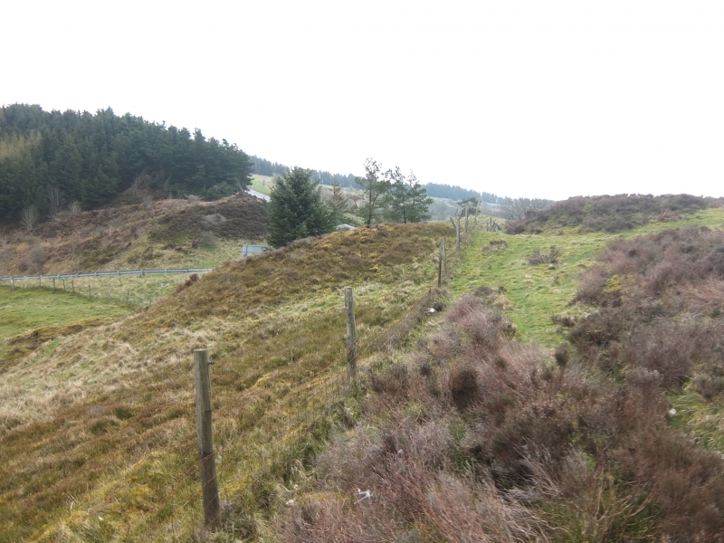
Gallows dyke extends for 160m across a narrow peninsula at the north eastern
corner of the moor. The central part of the dyke crosses generally level
ground but at either end the ground slopes down and the dyke terminates at
the top of the steeply sloping moor edge to the north and south. The dyke
includes a single ditch with flanking banks. The ditch is 3m wide and the
current base is up to 2.3m below the top of the banks. The eastern bank is
more substantial than the western and stands up to 1.25m above the surrounding
ground and is up to 4m wide. The ditches at other dykes elsewhere on the
moor were constructed by digging a series of pits which were joined together
and it is thought that this technique was used here. There are at least
two substantial hollow ways crossing the dyke which provided access to and
from the moor. These routeways are of some antiquity although it is not yet
known if their earliest use is contemporary with the construction of the dyke.
At either end of the dyke there is a post-medieval boundary stone which
marks a later estate boundary.
The round barrows lie 40m to the east of the dyke, in a line extending north
to south. Each of the barrows has a steep sided earth and stone mound. They
each measure up to 12m in diameter and are 1.5m high. The mounds are very
close together so there is no significant gap between the mounds and
therefore it is unlikely that they were surrounded by ditches. Each of the
mounds has a slight hollow on the top which is the result of investigations in
the past.
Although the barrows were constructed primarily for burials, it is believed
that barrows located in prominent positions such as these also served as
boundary markers defining territories. The use of the dyke as a territorial
marker continues today as the parish boundary extends along the length of the
dyke.
All fence and gate posts and the stone information plinth are excluded from
the scheduling, although the ground beneath these features is included.
MAP EXTRACT
The site of the monument is shown on the attached map extract.
It includes a 3 metre boundary around the archaeological features,
considered to be essential for the monument's support and preservation.
Source: Historic England
Cross dykes are substantial linear earthworks typically between 0.2km and 1km
long and comprising one or more ditches arranged beside and parallel to one or
more banks. They generally occur in upland situations, running across ridges
and spurs. They are recognised as earthworks or as cropmarks on aerial
photographs, or as combinations of both. The evidence of excavation and
analogy with associated monuments demonstrates that their construction spans
the millennium from the Middle Bronze Age, although they may have been re-used
later. Current information favours the view that they were used as territorial
boundary markers, probably demarcating land allotment within communities,
although they may also have been used as trackways, cattle droveways or
defensive earthworks. Cross dykes are one of the few monument types which
illustrate how land was divided up in the prehistoric period. They are of
considerable importance for any analysis of settlement and land use in the
Bronze Age. Very few have survived to the present day and hence all well-
preserved examples are considered to be of national importance.
Round barrows are funerary monuments dating from the Late Neolithic period to
the Late Bronze Age, with most examples belonging to the period 2400-1500 BC.
They were constructed as earthen mounds, sometimes ditched, which covered
single or multiple burials. They occur either in isolation or grouped as
cemeteries and often acted as a focus of burials in later periods. Often
superficially similar, although differing widely in size, they exhibit
regional variations in form and a diversity of burial practices. There are
over 10,000 surviving examples recorded nationally (many more have already
been destroyed), occurring across most of Britain, including the Wessex area
where it is often possible to classify them more closely, for example as bowl
or bell barrows. Often occupying prominent locations, they are a major
historic element in the modern landscape and their considerable variation in
form and longevity as a monument type provide important information on the
diversity of beliefs and social organisations amongst early prehistoric
communities. They are particularly representative of their period and a
substantial proportion of surviving examples are considered worthy of
protection.
Hollow ways are route ways which over a period of many years have worn a
substantial corridor out of the surrounding land. They sometimes start off
or are managed by deliberate cutting and recutting. Hollow ways can date from
all periods and in some cases can be in use for thousands of years. As a
result they can illustrate patterns of communication over many years and are
an important element in understanding how the land was used at particular
times.
The Gallows Dike survives well and significant evidence of its date and
construction will be preserved. The barrows also survive well and will provide
important information about their original form, the burials placed within
them and their relationship with other monuments in the area. Evidence of
earlier land use will also survive beneath the barrow mounds. Taken together
the monument preserves important information about the use and development of
this part of Levisham Moor.
Source: Historic England
Books and journals
Atkins, C, An Archaeological Survey of the Levisham Estate, (1991)
Atkins, C, An Archaeological Survey of the Levisham Estate, (1991), 5-12
Atkins, C, An Archaeological Survey of the Levisham Estate, (1991), 5-12
Spratt, D A, Prehistoric and Roman Archaeology of North East Yorkshire, (1994), 111-121
Vyner, B E, 'CBA Research Report 101: Moorland Monuments' in The Brides Of Place: Cross-Ridge Boundaries Reviewed, , Vol. CBA 101, (1995), 16-31
Other
Vyner, B, (2000)
Source: Historic England
Other nearby scheduled monuments