Approximate Location Map
Large Map »
This site is entirely user-supported. See how you can help.
Latitude: 50.3297 / 50°19'47"N
Longitude: -4.6381 / 4°38'17"W
OS Eastings: 212335.848093
OS Northings: 51085.393072
OS Grid: SX123510
Mapcode National: GBR N6.XNGF
Mapcode Global: FRA 1855.8X0
Entry Name: Polruan Blockhouse
Scheduled Date: 30 November 1959
Last Amended: 14 March 2000
Source: Historic England
Source ID: 1019056
English Heritage Legacy ID: 31863
County: Cornwall
Civil Parish: Lanteglos
Built-Up Area: Polruan
Traditional County: Cornwall
Lieutenancy Area (Ceremonial County): Cornwall
Church of England Parish: Lanteglos-by-Fowey
Church of England Diocese: Truro
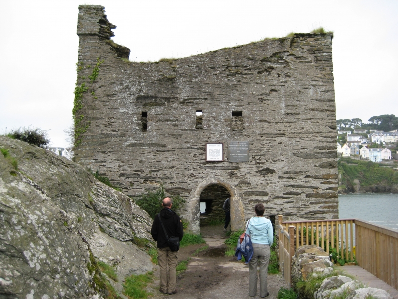
The monument includes a chain tower known as Polruan Blockhouse on the south
coast of mid-Cornwall.
The chain tower survives as a two storied rectangular building constructed on
a low rocky promontory which juts out into the River Fowey, and is located
opposite another chain tower known as Fowey Blockhouse (SM 31864). The
structure is roofless and is orientated north west-south east. It is
constructed of the local slate stone with moulded granite surrounds to some
windows, gun ports and the main entrance. The tower is approached via a
footpath through Polruan, and is entered through the main doorway, with a
round arched, moulded granite surround at ground floor level in the south east
wall. To the north east of the entrance is a rectangular slit or gun port,
with three similar gun ports above the entrance. Built into the thickness of
the wall, they appear as wide rectangular openings on the interior narrowing
to slits on the exterior. Just above the ground floor gun port on the interior
is a small square hole or recess in the wall, known as a putlog hole. On the
southern corner at the top of the walls one crenellation survives. In the
eastern corner on the interior is a doorway with iron hinges for a door, and
the first few steps of a spiral staircase, with a doorway giving access to the
first floor. In the southern corner is a rounded recess which probably held a
spiral staircase from the first floor to the roof. On the ground floor of the
north east wall is another gun port and two putlog holes. The north east
ground floor wall appears thicker along this side, forming a wide ledge at
first floor level, and there are two further gun ports on the first floor.
This wall looks out towards the river mouth. The north west wall faces the
opposite bank of the river towards Fowey Blockhouse. This wall contains a
rectangular entrance with steps down to the rocky promontory, to give access
at ground level to the river, and a gun port to the north with a rectangular
recess or large putlog hole above. Again this wall is wider, forming a narrow
ledge at first floor level, with two further gun ports with granite surrounds.
The western gun port is in the shape of an inverted keyhole. The south west
wall faces upriver and contains a fireplace at ground floor level, with a gun
port (probably later) inserted into its back wall, and a fireplace with
chimney on the first floor. To the east of the ground floor fireplace is a
window with granite mullion and on the first floor is another similar window
to the west of the upper fireplace. The upper fireplace had a large slate
mantel. The ledges formed by the two thicker walls may have been to support
floorboards, or to strengthen those walls most likely to come under attack.
The windows and fireplaces are in the wall looking upriver, from which
direction attack was least likely. The tower is a Listed Building
Grade II*.
Both this chain tower and the one on the opposite side of the river were
probably built in response to a raid on the town of Fowey by the French in
1457. Leland, travelling in the 16th century, states that the towers were
built during the reign of Edward IV (1461-1483). Polruan Blockhouse was
equipped for use with guns, the inverted keyhole gun port in the upper north
east wall, and the timbers set into the sills of the three first floor gun
ports above the south east entrance for the mounting of small guns, support a
mid- to late 15th century date. The two chain towers were designed to have a
chain laid across the river between them which could be raised to prevent
enemy shipping reaching the town of Fowey. Leland also records that after
hostilities with the French ceased, the men of Fowey continued to raid French
shipping and as a punishment had their ships confiscated by the men of
Dartmouth and the chain between the two towers removed. In 1776 two links of a
large chain were dredged up from the Fowey estuary, which were believed to be
part of the chain across the river. Advances in artillery made the tower
obsolete and it was superseded by St Catherine's Castle in the 1520s, on the
opposite side of the river.
The tower is illustrated on a map of around 1540. Marked `decayed', it is
shown as a two storied building with crenellations and possibly a wall
extending out along the rocky promontory. An engraving of 1786 also shows a
crenellated wall extending along the promontory though an earlier engraving of
1734 does not. Possibly this wall, of which there is no trace today, protected
access to one end of the chain across the harbour mouth. This tower was reused
during the Civil War. In 1644 the Parliamentarians were being forced to
retreat down the Fowey peninsula and were hoping to escape from Fowey by ship,
however the Royalists seized and held Polruan Blockhouse, so giving them
control over shipping entering or leaving Fowey. The later gun port inserted
into the ground floor fireplace in the north east wall may have been made at
this time.
The lifebelt and its box on the exterior of the north west wall, the two
information plaques above the south east entrance, the cable along the wall to
the south of this entrance and the concrete surface of the footpath to the
south east entrance are excluded from the scheduling, although the ground
beneath all these features is included.
MAP EXTRACT
The site of the monument is shown on the attached map extract.
It includes a 2 metre boundary around the archaeological features,
considered to be essential for the monument's support and preservation.
Source: Historic England
A chain tower is a small structure built beside a river or harbour to house
the mechanism for raising and lowering a defensive chain to prevent the
passage of ships in times of danger. They were built on the east, south and
south west coasts of England on the important maritime approaches, such as
those of Portsmouth, Plymouth and Dartmouth. The approach and towns in the
Thames estuary were also chained. There were only 14 examples recorded
nationally, and of these only five are known to have extant remains.
The chain was normally laid across the river bed from bank to bank and raised
when necessary. One or both ends of the chain would have a tower or building
to house the lifting mechanism, and the other end would have a simpler means
of attaching the end of the chain. Chain towers were usually strong, stone
structures, capable of being defended, sometimes with dry moats or ditches to
the landward side, and with accommodation for short term use by operators of
the chain and a defensive garrison. There was a great variety in design. The
earliest completed example is at Fowey, Cornwall, built after a raid on the
town in 1457; a later example is at Gillingham, Kent, in 1667; most were
constructed in the late 16th century.
The Polruan chain tower known as Polruan Blockhouse is one of only five known
to exist in England. It and the chain tower on the opposite bank of the River
Fowey are the earliest chain towers to have been constructed. The Polruan
chain tower is also one of the most complete examples of a chain tower, being
little altered since its construction. It became obsolete in the 1520s when St
Catherine's Castle was built at Fowey, although it was reused briefly during
the Civil War.
Source: Historic England
Books and journals
Chandler, J, John Lelands Itinerary: Travels in Tudor England, (1993)
Keast, J, The Story of Fowey, (1987)
Keast, J, The Story of Fowey, (1987)
Keast, J, The Story of Fowey, (1987)
Keast, J, The Story of Fowey, (1987)
Saunders, A D, Fortress Britain, (1989)
Saunders, A D, Fortress Britain, (1989)
Brown, S, 'Devon Archaeological Society Proceedings, Berry Pomeroy Castle' in Berry Pomeroy Castle, , Vol. No 54, (1996)
Parnell, G, 'Devon Archaeological Society Proceedings, Berry Pomeroy Castle' in The Gunports at Berry Pomeroy Castle, , Vol. No.54, (1996)
Other
Consulted January 1999, Cornwall SMR entry for PRN No. 26851,
Title: 1:25000 Ordnance Survey Map; SX 05/15; St Austell and Fowey
Source Date: 1980
Author:
Publisher:
Surveyor:
Source: Historic England
Other nearby scheduled monuments