Approximate Location Map
Large Map »
This site is entirely user-supported. See how you can help.
Latitude: 54.471 / 54°28'15"N
Longitude: -0.8199 / 0°49'11"W
OS Eastings: 476578.742765
OS Northings: 509042.724013
OS Grid: NZ765090
Mapcode National: GBR QJQR.91
Mapcode Global: WHF8Q.CWTB
Entry Name: Round barrow on Lealholm Rigg, 710m south west of Green Houses Farm
Scheduled Date: 9 January 1963
Last Amended: 2 December 1998
Source: Historic England
Source ID: 1018748
English Heritage Legacy ID: 30185
County: North Yorkshire
Civil Parish: Glaisdale
Traditional County: Yorkshire
Lieutenancy Area (Ceremonial County): North Yorkshire
Church of England Parish: Glaisdale St Thomas
Church of England Diocese: York
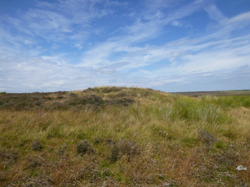
The monument includes the buried and earthwork remains of a prehistoric burial
mound on the top of Lealholm Rigg.
The monument is sited on gently sloping ground, about 0.5m below and 50m-60m
north east of the summit of the Rigg. It is prominently sited on the skyline
viewed from the ridge that forms Lealholm Moor and commands views to the north
and east. The barrow is more complex in form than most in the area as it is
made up of two mounds with a second smaller mound placed on top of the first.
The main mound is 19m in diameter across its base, 0.5m high with a flat top
approximately 15m in diameter. The second mound is 8m in diameter across its
base and is sited in the north eastern quadrant of the top of the lower barrow
to leave a berm 0.5m wide on the north eastern side widening to about 7m on
the south western side. The smaller, upper mound is 1m high so that the whole
barrow stands to 1.5m. The centre of the upper mound has a central depression
up to 0.7m deep. The mound's location mirrors that of the barrow 150m to the
south west which is just below the southern side of the summit.
Excavation of other barrows has shown that even where no encircling depression
is discernible on the modern ground surface, ditches immediately around the
outside of barrows frequently survive as infilled features, containing
additional archaeological deposits.
MAP EXTRACT
The site of the monument is shown on the attached map extract.
It includes a 2 metre boundary around the archaeological features,
considered to be essential for the monument's support and preservation.
Source: Historic England
Bowl barrows, the most numerous form of round barrow, are funerary monuments
dating from the Late Neolithic period to the Late Bronze Age, with most
examples belonging to the period 2400-1500 BC. They were constructed as
earthen or rubble mounds, sometimes ditched, which covered single or multiple
burials. They occur either in isolation or grouped as cemeteries and often
acted as a focus for burials in later periods. Often superficially similar,
although differing widely in size, they exhibit regional variations in form
and a diversity of burial practices. There are over 10,000 surviving bowl
barrows recorded nationally (many more have already been destroyed), occurring
across most of lowland Britain. Often occupying prominent locations, they are
a major historic element in the modern landscape and their considerable
variation of form and longevity as a monument type provide important
information on the diversity of beliefs and social organisations amongst early
prehistoric communities. They are particularly representative of their period
and a substantial proportion of surviving examples are considered worthy of
protection.
Excavation of round barrows in the region have shown that they demonstrate a
very wide range of burial rites from simple scatters of cremated material to
coffin inhumations and cremations contained in urns, typically dating to the
Bronze Age. A common factor is that barrows were normally used for more than
one burial and that the primary burial was frequently on or below the original
ground surface, often with secondary burials located within the body of the
mound. Most barrows include a small number of grave goods. These are often
small pottery food vessels, but stone, bone, jet and bronze items have also
occasionally been found.
The barrow 710m south west of Green Houses Farm is a well preserved example of
one of the more complex barrows found on the moors.
Source: Historic England
Books and journals
Smith, M J B, Excavated Bronze Age Burial Mounds of Durham and N' land., (1994)
Source: Historic England
Other nearby scheduled monuments