Approximate Location Map
Large Map »
This site is entirely user-supported. See how you can help.
Latitude: 53.8217 / 53°49'18"N
Longitude: -1.6076 / 1°36'27"W
OS Eastings: 425929.211992
OS Northings: 436234.265142
OS Grid: SE259362
Mapcode National: GBR B39.BS
Mapcode Global: WHC9C.86QJ
Entry Name: Kirkstall Abbey and precinct including a prehistoric cup and ring marked rock
Scheduled Date: 8 February 1915
Last Amended: 10 February 1998
Source: Historic England
Source ID: 1018149
English Heritage Legacy ID: 29904
County: Leeds
Electoral Ward/Division: Kirkstall
Traditional County: Yorkshire
Lieutenancy Area (Ceremonial County): West Yorkshire
Church of England Parish: Kirkstall St Stephen
Church of England Diocese: Leeds
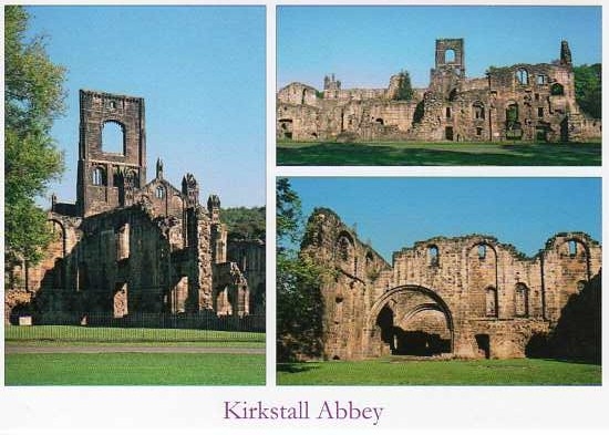
The monument includes the standing and below ground remains of Kirkstall
Abbey. The site lies in a valley on the north bank of the River Aire and
straddles the A65 (Abbey Road) which was cut through the precinct in 1827. The
key monastic buildings which have been identified include the church,
cloister, infirmary, chapel, abbots lodging, refectory, Guest House, pantry,
buttery and other associated buildings. The monument also includes the abbey
precinct with its perimeter wall, inner and outer gatehouses, the Vesper Gate
and the earthwork remains of the water management system. A prehistoric cup
and ring marked rock which lies within the precinct is also included in the
scheduling.
Kirkstall Abbey, a Grade I Listed Building, was a daughter house of Fountains
Abbey and was founded in 1152 by a community of Cistercian monks, led by Abbot
Alexander. The monks originally left Fountains Abbey to found a monastery on
the lands of Henry de Lacy in the village of Barnoldswick. The climate and
hostility of the local people made life difficult, so the monastery was
relocated to Kirkstall. The church, cloister and surrounding buildings were
completed by 1182 when Abbot Alexander died. Generous donations in the 13th
century made the abbey a major land owner in Airedale and a thriving producer
of wool. Medieval monasteries were essentially self contained and self
sustained institutions depending on income from agricultural and industrial
estates, and Kirkstall was no exception. Although the community depended
heavily on the production of wool, a reference to two mills and a forge
demonstrates the overall diversity of the economy at Kirkstall. Monastic life
came to an end in 1539 when Abbot John Ripley surrendered the abbey to Henry
VIII's commissioners.
Initially all the buildings were constructed of wood but these were replaced
almost immediately by Bramley Fall gritstone structures. The abbey church,
which survives to roof level, is aligned east to west and was built in a
symbolic cross shape. A tower which stands to the east end of the church is
flanked on either side by transepts and it is these which give the abbey its
characteristic cruciform. A door in the north transept gave access to the
cemetery; the southern transept housed the night stairs which led from the
monks' dormitory. Beyond the tower to the east lies the presbytery where the
high altar stood and where mass was held. The appearance of the abbey was
changed in the early 16th century, with battlements and corner turrets added
to the roof and the great central tower enlarged to house a belfry. The
tower bears the initials of Abbot William Marshall, the instigator of these
changes. The weight of the extension led to the collapse of the north west
corner of the tower in 1779 and damage to two piers of the North Aisle.
To the south of the church lies the cloister, an open square courtyard
surrounded by covered walkways. The walkways provided access to various
buildings in the surrounding ranges. The buildings enclosing the cloister are
well preserved, many still standing to roof height and others to at least
first floor level.
The northern arcade served as a scriptorium (where books were copied) whilst
that to the west backed onto the lay brothers lane and was used as a
corridor. Openings in the east arcade include the book cupboard and doors to
the library, the chapter house, the parlour, the day stairs to the monks
dormitory and the passage to the infirmary. The southern arcade gave access to
the warming house where, during the coldest months of the year, a fire was lit
in order to offer warmth to the monks and to keep records dry in the room
above. The southern arcade also gave access to the towel cupboard, the
lavatorium (where the monks washed before dinner), the refectory, kitchens and
malthouse. The library was altered during the 19th century for use as a summer
house by the occupants of Abbey house.
To the south east of the church is the chapter house. Here the community met
with the abbot to commemorate their saints and deceased brothers, to hear a
chapter of the rule of St Benedict, to confess and receive correction and to
transact their business.
To the south east of the chapter house, and linked to the eastern range, is
the infirmary which was used for the care of old or sick monks. This
rectangular building was originally built in the 13th century but was later
remodelled with further improvements being made in the 15th century. A
separate chapel was provided to serve the infirmary and was located to the
south west and linked by a covered passage. On the ground floor of the
infirmary chapel was a kitchen which served not only the infirmary but the
visiting abbots lodging which was attached to the southern wall of the
infirmary. This group of buildings has suffered from stone robbing and survive
only as low walls, but the layout of the buildings and their relationship to
other buildings is still clearly visible.
The southern range housed the domestic buildings. These include the abbot's
lodgings, the reredorter (the latrines for the choir monks dormitory and the
abbots lodgings), the warming house, meat kitchen, the refectory and the
kitchen. To the west of this complex of buildings is a lane which provided
access to the west range. The upper floor of the west range was used as the
lay brothers' dormitory. A door led to the lay brothers' reredorter at first
floor level, a building situated at right angles to the southern end of the
laybrothers' dormitory. The vaulted ground floor of the west range served as
their refectory, cellarium (storehouse) and, at the north end, as an outer
parlour where monks could meet with outsiders. The western and southern walls
of this building collapsed in about 1750.
To the west of the church and cloister lies the Guest House, the bakehouse and
what is believed to be the lay brothers infirmary. All these were cleared to
ground level during the Dissolution. Excavation of the guesthouse, which is a
Grade II listed building, between 1980 and 1988 revealed that it was
constructed between the 13th and 15th centuries and took the form of a
medieval manor house with an aisled hall open to the roof and a central
hearth. At the northern end a two storey great chamber was provided for the
most important guests. To the south a domestic wing included a pantry and
buttery. Both ends of the building were provided with latrines which were
built over a main subterranean drain. Later the building was extended to
incorporate stables, a kitchen and a scullery arranged around a small
courtyard to the south.
Excavations at Kirkstall in the 1950s recovered evidence of a developed water
system, of which the earliest phase was contemporary with the earliest stone
buildings. The supply was provided by a pipe running from the direction of
the infirmary to feed a cistern in the south east corner of the cloister,
passing through and contemporary with the footings of the east range. The
cistern acted as a filter and waste water was carried away to the south in a
drain below the south cloister range, where it ran into the main monastic
sewer to help flush the monks' latrines. The layout of the plumbing was
extended in the late 12th century when the refectory was rebuilt and provided
with a lavatorium set in the south wall of the adjacent cloister walkway.
Additional pipework running from the west range provided water to the scullery
to the south of the Guest House kitchen. A pipe was also run from the old
laver in the cloister, through the warming room to a stone lined cistern in
the yard to the south. From here a water supply was taken south, in a stone
culvert below the monastic sewer to other unexcavated buildings in the inner
precinct. A small laver against the west wall of the refectory was fed by a
pipe which led from the new lavatorium in the south wall of the cloister.
Stone built drains were provided to carry away waste water from the kitchen,
the scullery and from the west range, discharging into the main sewer. Further
pipe work associated with the water supply system remain unexcavated.
Situated to the north of Abbey Road and to the east of Abbey Walk is the inner
gatehouse. The inner gatehouse provided access between the inner precinct, in
which the core ecclesiastical buildings were located, and the wider outer
precinct. The inner precinct would have been enclosed in some way, probably by
a wall. Unfortunately nothing survives above ground to indicate the position
of this wall. The gatehouse was constructed in the 12th century of coursed
squared gritstone with a stone slate roof. The ground floor is three bays deep
and forms a vaulted passage which would have provided the main access to the
inner precinct. Upper rooms were reached by a stone spiral staircase on the
south west corner. In the 15th-16th centuries a new wing was built to the
south west and after the Dissolution the gatehouse was converted to a dwelling
house. Further additions were made in the early 20th century. The building now
houses the Abbey House Museum and is a Grade II* Listed Building.
At the junction between Abbey Walk, Spen Lane and Morris Lane, and beneath the
current road surface, lie the remains of the outer gate. This would have
served as the main entrance for people coming into the abbey precinct which
was surrounded by a high wall. Remains of the road linking the inner
gatehouse and the outer gate were uncovered during excavations in 1994.
Other standing remains include a single pillar of the Vesper Gate. This is
situated approximately 280m north west of the Abbey House Museum and to the
north of Vesper Lane. This gate served as the western entrance to the
precinct and led on to Vesper Lane, a path or bridle track which ran from
Horsforth Woodside (about 1.5km north west of the abbey) through Hawksworth
Wood to the inner gatehouse. Within the outer precinct area the trackway ran
along the top of a medieval dam built to retain water in the abbey mill pond
to the north of the track. The pond was fed by a small stream known as Hell
Hole Gill which ran north to south through the precinct. The stream,
originating at Hawksworth Wood, entered the precinct through the northern wall
and continued south (now beneath Abbey Road) to meet the river between the
Guest House and the modern tennis courts. A line of mature trees towards the
northern edge of the precinct may mark the line of this early watercourse.
The dam formed part of a unique water management system which powered at least
two corn mills. A surviving description of the abbey precinct at the time of
the suppression describes two corn mills powered by water, but their precise
location is not documented. The pond was infilled in about 1978 to reclaim the
land for use as a playing field.
The precinct wall survives in a number of places around the perimeter of the
abbey complex and would have served to contain the community. The most obvious
remains survive to a height of approximately 1m and can be found incorporated
into the northern boundary of the field to the east of the museum. Further
standing remains are evident to the south of Vesper Gate incorporated into the
eastern boundary of Vesper Lodge. The line of the eastern precinct wall was
revealed during excavation in 1990.
The outer precinct would have contained agricultural and industrial buildings,
as well as water meadows, pasture fields, orchards, mills and residential
buildings for craftsmen. The survival of such features at Kirkstall is
indicated by the extensive earthworks visible throughout the area. Other
remains will survive beneath the modern leisure facilities which have grown up
within the public park.
Following the Dissolution in 1539 the Abbey passed to Thomas Cranmer, the
Archbishop of Canterbury, but reverted to the Crown following his execution in
1556. In 1583-4 it was purchased by Robert Savile and it stayed within that
family until 1671 when it passed by marriage to the Brudenells, the Earls of
Cardigan. The building was stripped of its roofs, windows and furnishings and
became overgrown by trees and bushes. It became a romantic ruin, a fashionable
asset in the 17th and early 18th century, and was a popular subject for poets,
writers and painters. With the sale of the Cardigan estates in 1889 the site
passed to Colonel John North, a wealthy local business man who immediately
presented it to the City of Leeds for the enjoyment of its people.
The scheduling also includes a carved gritstone rock measuring 1.5m by 1.2m by
0.9m. It is situated in the public park south west of the remains of the Abbey
Guest House, 8m west of a path junction and 1.4m south of the edge of the
path. The carving on the east end of the rock consists of five cups, all with
single rings, one with a possible second ring and some with grooves from the
cup.
A number of features are excluded from the scheduling; these are the Abbey
House Museum, all modern path, road and car park surfaces, all modern fences
and walls, recreation facilities including rugby and football goal posts,
changing rooms, pavilions, tennis courts, bowling green, benches, picnic
tables, sculptures, information boards, toilets, wooden bridges, rubbish bins
and lighting; the ground beneath all these features is, however, included.
MAP EXTRACT
The site of the monument is shown on the attached map extract.
Source: Historic England
From the time of St Augustine's mission to re-establish Christianity in AD 597
to the reign of Henry VIII, monasticism formed an important facet of both
religious and secular life in the British Isles. Settlements of religious
communities, including monasteries, were built to house communities of monks,
canons (priests), and sometimes lay-brothers, living a common life of
religious observance under some form of systematic discipline. It is estimated
from documentary evidence that over 700 monasteries were founded in England.
These ranged in size from major communities with several hundred members to
tiny establishments with a handful of brethren. They belonged to a wide
variety of different religious orders, each with its own philosophy. As a
result, they vary considerably in the detail of their appearance and layout,
although all possess the basic elements of church, domestic accommodation for
the community, and work buildings. Monasteries were inextricably woven into
the fabric of medieval society, acting not only as centres of worship,
learning and charity, but also, because of the vast landholdings of some
orders, as centres of immense wealth and political influence. They were
established in all parts of England, some in towns and others in the remotest
of areas. Many monasteries acted as the foci of wide networks including parish
churches, almshouses, hospitals, farming estates and tenant villages. Some 75
of these religious houses belonged to the Cistercian order founded by St
Bernard of Clairvaux in the 12th century. The Cistercians - or "white monks",
on account of their undyed habits - led a harsher life than earlier monastic
orders, believing in the virtue of a life of austerity, prayer and manual
labour. Seeking seclusion, they founded their houses in wild and remote areas
where they undertook major land improvement projects. Their communities were
often very large and included many lay brethren who acted as ploughmen,
dairymen, shepherds, carpenters and masons. The Cistercians' skills as farmers
eventually made the order one of the richest and most influential. They were
especially successful in the rural north of England where they concentrated on
sheep farming. The Cistercians made a major contribution to many facets of
medieval life and all of their monasteries which exhibit significant surviving
archaeological remains are worthy of protection.
Kirkstall Abbey is a unique example of early Cistercian architecture which in
many places still stands to its full height. The quantity and quality of
both archaeological and historical documentation provides a clear account of
the establishment, use and dissolution of the monastery and of the lifestyle,
economy and beliefs of the religious order. Kirkstall is unusual in that it
survived the renewed late 18th century interest in monastic sites. Many abbeys
at this time were transformed into houses or partly dismantled for
incorporation into garden schemes or wider landscape designs. Being located in
an open public park, Kirkstall has also escaped encroachment by growing urban
development. Both the standing and buried remains display a high level of
preservation. Areas of archaeological investigation and the extent of existing
earthworks attest to the level of survival of remains beneath the ground
surface.
Source: Historic England
Books and journals
Brears, P, Kirkstall Abbey, (1990)
Coppack, G, Abbeys and Priories, (1990), 90-91
Holbrey, R, Kirkstall Abbey Gatehouse Archaeological Evaluation, (1994), 1-8
Hope, St John WH, Bilson, J, 'The publications of the Thoresby Society' in Architectural Description of Kirkstall Abbey, , Vol. XVI, (1907)
Other
Weldrake, D J, Kirkstall Abbey Watching Brief, (1990)
West Yorkshire Archaeological Services, Kirkstall Abbey, The Guest House. An interim summary of the Exca, 1980,
Source: Historic England
Other nearby scheduled monuments