Approximate Location Map
Large Map »
This site is entirely user-supported. See how you can help.
Latitude: 54.4016 / 54°24'5"N
Longitude: -0.9647 / 0°57'52"W
OS Eastings: 467307.596813
OS Northings: 501175.208299
OS Grid: NZ673011
Mapcode National: GBR PKPJ.YX
Mapcode Global: WHF91.4MWJ
Entry Name: Flat Howe round barrow and wayside cross base
Scheduled Date: 27 February 1963
Last Amended: 19 March 1998
Source: Historic England
Source ID: 1017828
English Heritage Legacy ID: 30137
County: North Yorkshire
Civil Parish: Farndale East
Traditional County: Yorkshire
Lieutenancy Area (Ceremonial County): North Yorkshire
Church of England Parish: Westerdale Christ Church
Church of England Diocese: York
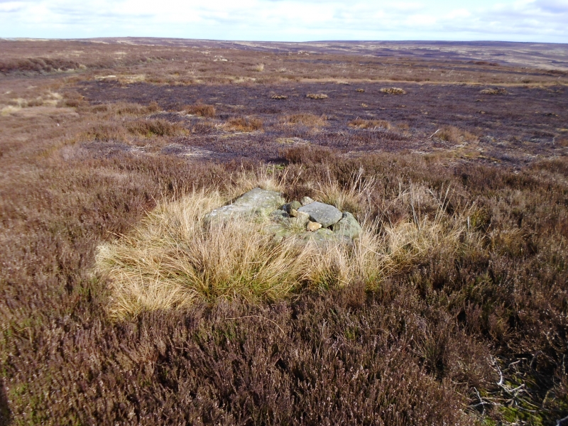
The monument includes the remains of a round barrow surviving as an
upstanding earthwork, surmounted by the remains of the base for a medieval
wayside cross. The barrow lies within heather moorland, 200m west of the
Castleton to Hutton-le-Hole road, and 30m NNW of a boundary stone marking the
boundary between Farndale East and Westerdale parishes.
The barrow survives as a 20m diameter mound, standing up to 0.7m high.
Excavations of similar barrows on the moors demonstrate that encircling
ditches are very common, although these tend to be silted, surviving as
infilled features. Flat Howe round barrow is also considered to have a mainly
silted encircling ditch. The top is slightly flattened and at its centre there
are the remains of a roughly dressed stone cross base. The base is square in
plan, 1m across with chamfered corners and a central socket for the cross
shaft measuring about 0.3m square. The cross base is thought to have
originally been of a single piece, but is now missing its south eastern corner
and the surviving section is split in two.
Flat Howe round barrow lies 240m west south west of the Margery Bradley
standing stone which is broadly of the same period and is the subject of a
separate scheduling.
MAP EXTRACT
The site of the monument is shown on the attached map extract.
It includes a 2 metre boundary around the archaeological features,
considered to be essential for the monument's support and preservation.
Source: Historic England
Bowl barrows, the most numerous form of round barrow, are funerary monuments
dating from the Late Neolithic period to the Late Bronze Age, with most
examples belonging to the period 2400-1500 BC. They were constructed as
earthen or rubble mounds, sometimes ditched, which covered single or multiple
burials. They occur either in isolation or grouped as cemeteries and often
acted as a focus for burials in later periods. Often superficially similar,
although differing widely in size, they exhibit regional variations in form
and a diversity of burial practices. There are over 10,000 surviving bowl
barrows recorded nationally (many more have already been destroyed), occurring
across most of lowland Britain. Often occupying prominent locations, they are
a major historic element in the modern landscape and their considerable
variation of form and longevity as a monument type provide important
information on the diversity of beliefs and social organisations amongst early
prehistoric communities. They are particularly representative of their period
and a substantial proportion of surviving examples are considered worthy of
protection.
Excavation of round barrows on the North Yorkshire Moors have shown that they
demonstrate a very wide range of burial rites from simple scatters of cremated
material to coffin inhumations and cremations contained in urns, typically
dating to the Bronze Age. A common factor is that the barrows were normally
used for more than one burial and that the primary burial was frequently on or
below the original ground surface, often with secondary burials located within
the body of the mound. Flat Howe round barrow is a good example of its type.
Many barrows were disturbed by antiquarians, especially in the 19th century,
but Flat Howe appears to have escaped any excavation. Flat Howe has an added
importance for being located close to a prehistoric standing stone, the
Margery Bradley stone.
The importance of the monument is heightened by the added historical interest
produced by the siting of a medieval wayside cross at its centre. Wayside
crosses are one of several types of Christian cross erected during the
medieval period, typically acting as waymarkers in otherwise unmarked terrain
for routes for parishioners from outlying settlements, for funeral
processions, long distance pilgrimage routes or merely the path linking
settlements. Over 350 wayside crosses are known nationally, concentrated in
the south west in Cornwall and on Dartmoor, with a small group found on the
North Yorkshire Moors. Wayside crosses contribute significantly to our
understanding of medieval religious customs, and to our knowledge of medieval
route ways and settlement patterns.
Source: Historic England
Other nearby scheduled monuments