Approximate Location Map
Large Map »
This site is entirely user-supported. See how you can help.
Latitude: 53.446 / 53°26'45"N
Longitude: -0.652 / 0°39'7"W
OS Eastings: 489628.22515
OS Northings: 395209.229532
OS Grid: SK896952
Mapcode National: GBR RXWL.ND
Mapcode Global: WHGGY.YNP1
Entry Name: Southorpe medieval settlement and cultivation remains
Scheduled Date: 6 February 1967
Last Amended: 7 July 1999
Source: Historic England
Source ID: 1016794
English Heritage Legacy ID: 22757
County: Lincolnshire
Civil Parish: Northorpe
Traditional County: Lincolnshire
Lieutenancy Area (Ceremonial County): Lincolnshire
Church of England Parish: Northorpe St John the Baptist
Church of England Diocese: Lincoln
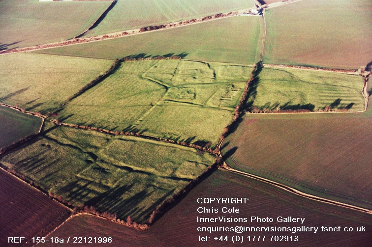
The monument includes the remains of the medieval settlement of Southorpe,
situated approximately 2km south of Northorpe on the eastern edge of the Trent
Valley. Recorded in the Domesday Book as one of two `Torps', it first appears
under its present name in a document of the 12th century in which reference is
made to the church at Southorpe. From the mid-14th to early 15th centuries
the manor was held by the D'Arcy family until the mid-16th century when it was
in the hands of the Conyers family. The population of Southorpe remained small
throughout the medieval period and finally declined during the 15th century
with the conversion of arable to sheep pasture. The church remained standing
until the early 16th century, and the most recent buildings to occupy the site
of the moated manor were taken down in 1966.
The settlement remains are centred in two areas, linked by a hollow way, on
either side of the small valley of an east-flowing tributary of the River Eau.
The remains take the form of substantial earthworks, standing to a height of
about 1m, with underlying archaeological deposits. The principal settlement
remains, including the site of the manor and church, occupy the higher ground
on the north side of the valley. Adjacent to part of the northern edge of
these settlement remains is a hollow way aligned approximately east-west; at
its western end it is met by another hollow way running north-south. Extending
both east and west from the angle of these two former streets is a series of
small ditched enclosures representing house plots, which are thought to have
surrounded and then encroached upon a village green. A triangular plot to the
east of these enclosures is thought to represent the latest extent of the
green prior to the desertion of the settlement; beyond it the hollow way
continues eastward with the remains of another enclosure on its northern side.
Immediately south of the northernmost block of settlement remains is a further
series of enclosures, also extending east-west across the slope: at its
eastern end is a moated site, at its western end a raised platform thought to
represent the site of the church and churchyard, and between them a small
group of fishponds. These features represent the remains of the manorial
complex which dominated the settlement during the Middle Ages. The moated
site, although partly levelled during clearance activities in 1966,
survives as a substantial earthwork. Buried remains within the moated island
will include the foundations of the medieval manor house and associated
structures. The moat itself, formerly at least 2m deep, has been partly
infilled and is now visible as a depression 0.5m deep. A later raised trackway
separates the moated site from a small group of fishponds lying in a
rectangular enclosure adjacent to the west. Two rectangular ponds, surviving
to a depth of about 1m, are arranged in a north-south line with a small tank
at the southern end. West of the fishponds is a smaller raised enclosure
within which are the earth-covered foundations of a stone building aligned
east-west; these are thought to represent the remains of the Church of St
Martin, first recorded in the 12th century and dismantled in the early 16th
century.
Immediately to the east, west and south of the northern settlement and
manorial complex are the earthwork remains of medieval ridge and furrow
cultivation. Those immediately south of the fishponds and church site lie
within a large rectangular enclosure partly bounded by a linear bank; this
enclosure is thought to have been incorporated within the manorial complex.
Running along its western side is the hollow way which links the northern
group of settlement remains with those on the south side of the stream. At
its southern end this hollow way is joined at right angles by another, which
runs east-west parallel to the stream. Rectangular ditched enclosures on both
sides of this hollow way represent house plots, those on the south side having
been laid out over earlier arable fields. Ridge and furrow cultivation remains
still survive adjacent to the south of these features, representing, together
with the ridge and furrow north of the stream, the only surviving fragments of
a once extensive area of cultivation remains surrounding the medieval
settlement of Southorpe.
All fences and gates are excluded from the scheduling, although the ground
beneath these features is included.
MAP EXTRACT
The site of the monument is shown on the attached map extract.
Source: Historic England
Medieval rural settlements in England were marked by great regional diversity
in form, size and type, and the protection of their archaeological remains
needs to take these differences into account. To do this, England has been
divided into three broad Provinces on the basis of each area's distinctive
mixture of nucleated and dispersed settlements. These can be further divided
into sub-Provinces and local regions, possessing characteristics which have
gradually evolved during the last 1500 years or more.
This monument lies in the Trent sub-Province of the Central Province, where
the broad Trent valley swings in a great arc across midland England. Underlain
by heavy clays, it is given variety by superficial glacial and alluvial
deposits. Although treated as a single sub-Province, it has many subtle
variations. Generally, it is characterised by a great number of villages and
hamlets which cluster thickly along scarp-foot and scarp-tail zones, locations
suitable for exploiting the contrasting terrains. Throughout the sub-Province
there are very low and extremely low densities of dispersed farmsteads, some
of which are ancient, but most of which are 18th-century and later movement of
farms out of earlier villages.
Medieval villages were organised agricultural communities, sited at the centre
of a parish or township, that shared resources such as arable land, meadow and
woodland. Village plans varied enormously, but when they survive as
earthworks their most distinguishing features include roads and minor tracks,
platforms on which stood houses and other buildings such as barns, enclosed
crofts and small enclosed paddocks. They frequently included the parish
church within their boundaries, and as part of the manorial system most
villages included one or more manorial centres which may also survive as
visible remains as well as below ground deposits. Villages were the most
distinctive aspect of medieval life in central England, and their
archaeological remains are one of the most important sources of understanding
about rural life in the five or more centuries following the Norman Conquest.
Medieval settlements were supported by a communal system of agriculture based
on large, unenclosed open arable fields. These large fields were subdivided
into strips (known as lands) which were allocated to individual tenants. The
cultivation of these strips with heavy ploughs pulled by oxen-teams produced
long, wide ridges, and the resultant `ridge and furrow' where it survives is
the most obvious physical indication of the open field system. Individual
strips or lands were laid out in groups known as furlongs, which were in turn
grouped into large open fields. Well preserved ridge and furrow, especially
in its original context adjacent to settlement earthworks, is both an
important source of information about medieval agrarian life and a distinctive
contribution to the character of the historic landscape.
The medieval settlement of Southorpe, and the remains of its open field
system, survive well as a series of substantial earthworks. As a result of
detailed archaeological survey and historical research they are quite well
understood. The remains of house plots and hollow ways will preserve valuable
evidence for domestic and economic activities on the site, giving an insight
into the lifestyle of the inhabitants. Despite partial levelling of the
moated site in modern times, archaeological deposits of medieval date survive
largely intact. The buried remains of manorial buildings here, together
with those of the associated church and churchyard, will demonstrate how these
components functioned as vital parts of the local and regional community. The
association of the village remains with those of its open fields will also
preserve evidence for the economy of the settlement and its place in the wider
medieval landscape.
Source: Historic England
Other nearby scheduled monuments