Approximate Location Map
Large Map »
This site is entirely user-supported. See how you can help.
Latitude: 53.3898 / 53°23'23"N
Longitude: -0.6767 / 0°40'36"W
OS Eastings: 488104.129361
OS Northings: 388926.284749
OS Grid: SK881889
Mapcode National: GBR RYQ7.9K
Mapcode Global: WHGHB.K2Z3
Entry Name: Moated manorial complex immediately north west of Elm Tree Farm
Scheduled Date: 21 January 1999
Source: Historic England
Source ID: 1016920
English Heritage Legacy ID: 31612
County: Lincolnshire
Civil Parish: Springthorpe
Traditional County: Lincolnshire
Lieutenancy Area (Ceremonial County): Lincolnshire
Church of England Parish: Heapham All Saints
Church of England Diocese: Lincoln
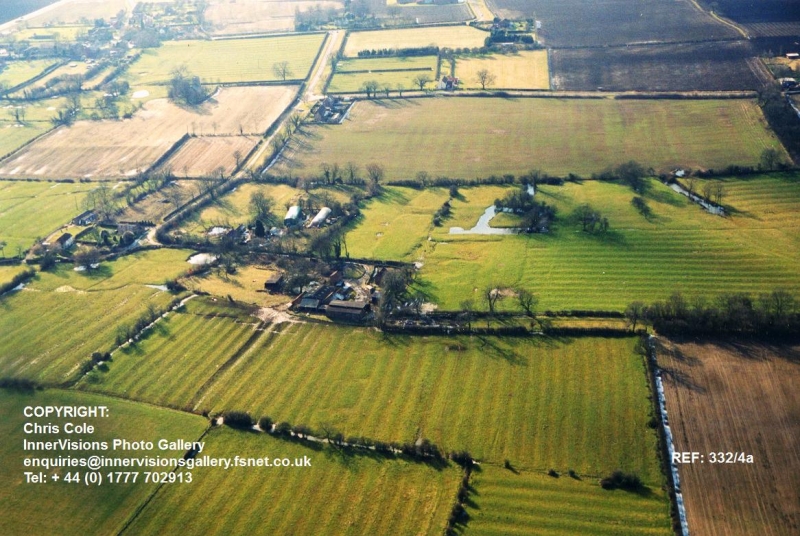
The monument includes a medieval manorial complex immediately north west of
Elm Tree Farm. The complex, lying to the north east of the village church,
represents one of two foci of settlement at Heapham. In 1086 Count Alan held
land at Heapham as part of his manor of Lea; during the 15th and 16th century
this holding thought to have been associated with the moated site, was linked
with the manor of North Ingleby. The visible remains of the complex include a
moated platform, or island, with a series of earthwork features, including
ditched enclosures and remains of medieval ridge and furrow cultivation
covering an area measuring approximately 310m by 240m.
The moated island takes the form of a roughly square platform, measuring 24m
across, completely enclosed by a water-filled moat, 8m to 12m wide. The
surface of the island is slightly uneven, being raised in places above the
general ground level, with a mound at the north west corner. Stone fragments
identified at the northern edge of the island, indicate that the remains of
structures survive on the island.
The moat is linked to the surrounding ditched enclosures via a series of
channels, which also formerly supplied water to the moat. An outlet from the
moat was provided on the western moat arm where a channel, or leat, interrupts
an external bank, to take water toward a ditch, at the western edge of the
complex. The western end of this channel is water-filled and now forms a pond.
Ditched enclosures lie on all sides of the moat. The plots are aligned east -
west and are generally subrectangular in plan, varying in size between 140m
and 150m in length and 40m and 25m in width. To the north of the ditched
enclosures there is a wide boundary ditch, which is now partly water-filled
and forms a pond. At its eastern end this ditch links into a narrower channel
which leads to the south to join the moat at its north eastern corner, from
where a ditch and bank continues to the east. These channels form part of the
system of water management and are thought to represent the original northern
limits of the manorial complex, within which service buildings, paddocks, and
gardens associated with the manor house would have been located.
An area of broad ridge and furrow lies to the north and east of the manorial
complex. The ridge and furrow to the north of the complex has been shortened
by the construction of the boundary ditch indicating that the complex was
established over fields of earlier medieval date.
All fences and water troughs are excluded from the scheduling, although the
ground beneath them is included.
MAP EXTRACT
The site of the monument is shown on the attached map extract.
Source: Historic England
Around 6,000 moated sites are known in England. They consist of wide ditches,
often or seasonally water-filled, partly or completely enclosing one or more
islands of dry ground on which stood domestic or religious buildings. In some
cases the islands were used for horticulture. The majority of moated sites
served as prestigious aristocratic and seigneurial residences with the
provision of a moat intended as a status symbol rather than a practical
military defence. The peak period during which moated sites were built was
between about 1250 and 1350 and by far the greatest concentration lies in
central and eastern parts of England. However, moated sites were built
throughout the medieval period, are widely scattered throughout England and
exhibit a high level of diversity in their forms and sizes. They form a
significant class of medieval monument and are important for the understanding
of the distribution of wealth and status in the countryside. Many examples
provide conditions favourable to the survival of organic remains.
The moated manorial complex immediately north west of Elm Tree Farm survives
well as a series of earthworks and buried deposits. Waterlogging in the moat
and boundary ditches will preserve organic remains (such as timber, leather
and seeds) which will give an insight into domestic and economic activity on
the site. In addition the banks round the moat and ditches will preserve
evidence of the land use prior to their construction.
As one of two foci of settlement, overlying earlier medieval fields, the
complex will preserve valuable evidence of the way in which the components of
the medieval landscape developed and interrelated. Archaeological survey and
documentary research has increased our understanding of the complex.
Source: Historic England
Other
Lidgett, Mr , (1998)
RCHM(E), Everson, P L and Taylor C C and Dunn, C J, Change And Continuity: Rural Settlement in North-West Lincolnshire, (1991)
Title: Heapham Tithe Award
Source Date: 1776
Author:
Publisher:
Surveyor:
Source: Historic England
Other nearby scheduled monuments