Approximate Location Map
Large Map »
This site is entirely user-supported. See how you can help.
Latitude: 52.4132 / 52°24'47"N
Longitude: -4.0898 / 4°5'23"W
OS Eastings: 257958
OS Northings: 281522
OS Grid: SN579815
Mapcode National: GBR 8R.P3N5
Mapcode Global: VH4FC.2L7W
Entry Name: Aberystwyth Castle
Scheduled Date:
Source: Cadw
Source ID: 764
Cadw Legacy ID: CD008
Schedule Class: Defence
Category: Castle
Period: Medieval
County: Ceredigion
Community: Aberystwyth
Built-Up Area: Aberystwyth
Traditional County: Cardiganshire
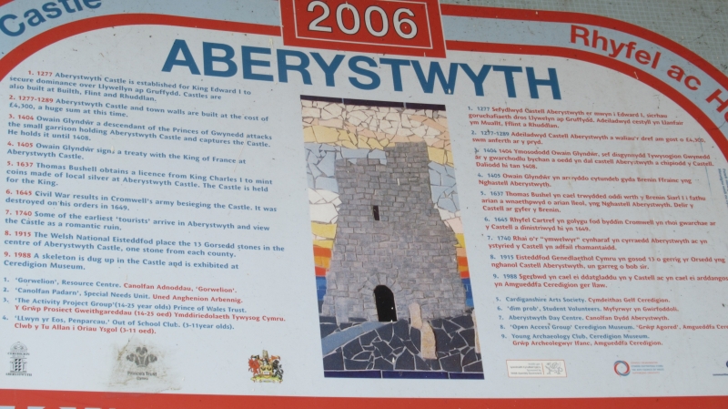
The monument consists of the remains of a castle, dating to the medieval period. A castle is a defended residence or stronghold, built mainly of stone, in which the principal or sole defence comprises the walls and towers bounding the site. Some form of keep may have stood within the enclosure but these were not significant in defensive terms and served mainly to provide accommodation. Aberystwyth Castle is a concentric-walled lozenge-plan castle measuring c.80m north-south by c.45m wide, built of coursed rubble masonry. It has a dry moat to the west and round towers to the inner and outer wards. There is an inner gate tower to the west with an outer gate beyond. The twin apsidal tower gateway has a pointed entrance, portcullis chase, crenellated parapet and splayed stair turret. There is a dungeon to the southwest and a mural tower on the south side of the inner ward. Work on Aberystwyth Castle commenced in 1277 under Edward I; it was taken by the Welsh in 1282 while still unfinished, and was completed (by the English again) in 1289. By 1636 the castle was largely ruinous and in 1637 a Royal Mint was established by Thomas Bushell in the castle hall. Around 1790 the ground in front of the castle was laid out in a series of walks by John Probert; this area is now partly covered by St. Michael’s Church. The castle remains have been much restored and now form part of a public park.
The monument is of national importance for its potential to enhance our knowledge of medieval defensive practices. The monument is well-preserved and an important relic of the medieval landscape. It retains significant archaeological potential, with a strong probability of the presence of both structural evidence and intact associated deposits.
The scheduled area comprises the remains described and areas around them within which related evidence may be expected to survive.
Source: Cadw
Other nearby scheduled monuments