Approximate Location Map
Large Map »
This site is entirely user-supported. See how you can help.
Latitude: 59.9717 / 59°58'18"N
Longitude: -1.342 / 1°20'31"W
OS Eastings: 436834
OS Northings: 1120936
OS Grid: HU368209
Mapcode National: GBR R21C.V38
Mapcode Global: XHD42.XMTD
Entry Name: St Ninian's Church and burial ground, St Ninian's Isle
Scheduled Date: 2 October 1970
Last Amended: 16 March 2012
Source: Historic Environment Scotland
Source ID: SM2933
Schedule Class: Cultural
Category: Ecclesiastical: burial ground, cemetery, graveyard
Location: Dunrossness
County: Shetland Islands
Electoral Ward: Shetland South
Traditional County: Shetland
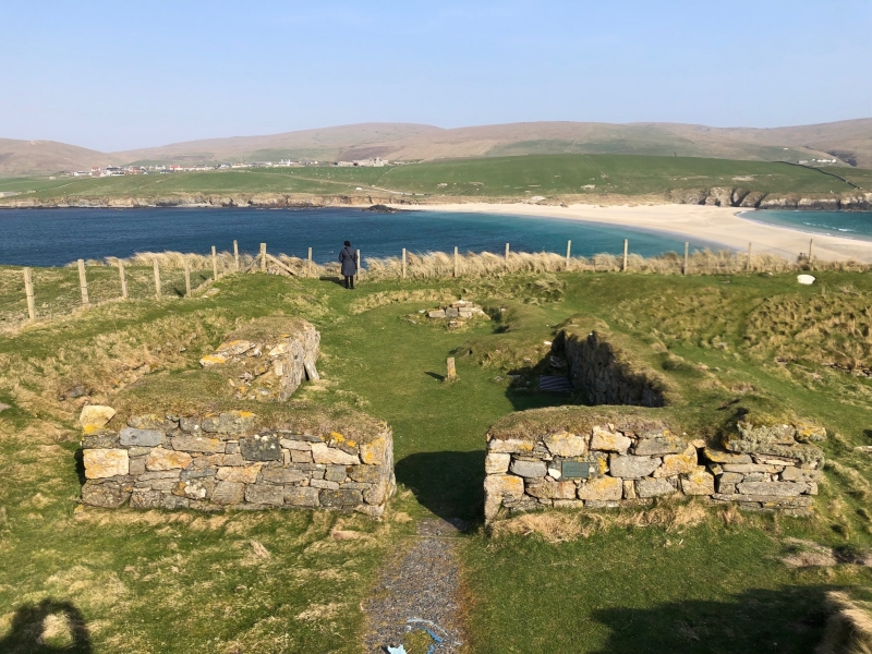
The monument comprises the remains of a small stone church likely to date to the 12th century; the foundations of an earlier stone church; building and occupation remains of Iron Age date (around 800 BC to AD 400); and a burial ground used for almost 2,000 years. The medieval church is visible as a set of low stone walls covered by turf, while the other elements of the monument survive as buried archaeological remains. The nave of the medieval church measures 9m E-W by 7.2m transversely, the walls standing about 1m above present ground level, while a probable round-ended chancel to the east measures around 5.5m E-W by 5.5m transversely.
The church was revealed by excavations conducted between 1955 and 1959. These are famous for the recovery of an unparalleled hoard of Pictish silver objects, but they also provided evidence for the lower courses of a probable early historic church at the S side of the medieval nave and for the remains of an Iron Age settlement. Many medieval and post-medieval burials were excavated during the investigations but the burials undoubtedly extend beyond the limit of excavation, while others were observed but not removed. Limited excavations in 1999-2000 clarified the date and character of some of the features south of the church, revealing some additional burials, and also investigated an area north of the church. The site lies on a gentle slope above the cliffs of the E coast of St Ninian's Isle, around 25m above sea level. To the SE it overlooks the dramatic sand tombolo that gives access to the island from the W coast of Mainland. The monument was first scheduled in 1970, but the documentation does not meet modern standards: the present rescheduling makes no change to the extent of the scheduled area, but improves the documentation.
The area to be scheduled is irregular on plan, with maximum dimensions of 146m N-S by 133m transversely, to include the remains described above and an area around them within which evidence relating to the monument's construction, use and abandonment may survive, as shown in red on the accompanying map. Towards the S end of the E boundary, the scheduled area extends up to and includes a stone revetment wall above the steep slope to the shore. The scheduling specifically excludes the above-ground elements of post-and-wire fences, gates, an interpretation board, a bench seat, an interpretation plaque on the church, and a metal grill protecting early foundations, to allow for the maintenance of all these features.
Source: Historic Environment Scotland
Cultural Significance
The monument's cultural significance can be expressed as follows:
Intrinsic characteristics
The excavations of 1955 to 1959 revealed part of a fascinating and complex archaeological site. Some of the remains discovered were reburied and still exist below ground, while other features clearly extend beyond the excavation area and survive as buried archaeology. After the medieval church was located, up to 2m of wind blown sand and thousands of medieval and later burials were removed in order to reveal the walls. During the work, the excavators recovered a fine collection of early Christian sculpted stones in and around the church and there is still potential for similar stones to be found in the vicinity. These included corner posts from early Christian shrines, some associated with a 'founders tomb' to the south of the chancel, a structure that may itself be of medieval date. Late Norse steatite crosses and a hogback stone dating from the 11th century were also recovered. However, the most famous find was made when a Shetland school boy, helping with the excavations, lifted a stone slab located towards the nave of the medieval church, and discovered a hoard of 28 silver objects buried in a larch box. In 2011 it still represents the largest collection of Pictish silver ever recovered. The silver may have been hidden to keep it safe from attacking Vikings and there has been much debate about whether it represents the plate of an 8th-century monastic community or the collection of a wealthy individual. In 1959 a trench was also opened to the south of the church, measuring 12m x 8m. Stone walls and paving were found in association with pottery that suggested these structures were part of a prehistoric Iron Age settlement. In addition, a stone wall aligned N-S was revealed, with a short cist containing a crouched adult skeleton inserted over the top. Three further cists were uncovered to the northwest and further box-like structures were noted to the east, but not excavated. Cist graves regarded as early Christian were also noted in the northeast of the trench.
Topographic survey and test pitting was conducted in 1999, demonstrating that the chapel and burial ground are part of a wider archaeological landscape. Finds included cultivated soils containing post-medieval pottery at the N end of the scheduled area. Two larger trenches were opened in 2000, one at least 5m north of the medieval church, the other to the south in the footprint of the 1959 investigation. The N trench revealed medieval and post-medieval burials and walls. The S trench uncovered a variety of features, including: cist graves earlier than those excavated in 1959 in the NE of the trench; a form of kerbed cairn beneath that, with six infant burials dating to around AD 890-990; and three burials without cists dating to about AD 1000-1200. Researchers suggest that the dates obtained from the 2000 excavations indicate that the short cist excavated in 1959 may be a pagan Viking burial. Artefacts from these investigations include gaming pieces, pottery, steatite weights and bone beads. The range of late Iron Age burials excavated in the area south of the church is unparalleled in Shetland and there is potential for similar burials to be found elsewhere in the immediate vicinity. Such graves offer opportunities to study the dramatic changes in belief and culture at this time, particularly the affects of the Norse incomers and the changes in pagan and Christian beliefs as the two cultures (Pictish and Norse) interacted.
The excavations conducted to date demonstrate that the preservation and condition of buried archaeological remains is good. It is clear that the monument contains a wealth of information and preserves a highly complex sequence of development present at few other known sites. There is potential to re-examine in detail the buried multiphase remains of the church and to assess its chronological relationship with the use of the burial ground and with the previous Iron Age settlement. It is probable that very large numbers of burials remain in situ, and these have high potential to enhance our knowledge of status and burial practice, and to reveal evidence for health, diet, illness, cause of death, and perhaps family relationships and the types of activities people undertook during life.
Contextual characteristics
Small churches of proven early historic date are rare in Scotland and few examples have been excavated to modern standards. However, the chapel, graves and artefactual evidence from this monument can be compared with the early historic chapel at Nesti Voe on the Isle of Noss, 25km to the NE, where corner posts from stone shrines and stones with early incised crosses have also been found. More distant comparisons can be drawn with the Pictish monastery at Portmahomack and with the excavated evidence and carved stones from Whithorn and Iona. The medieval church can be compared with others at Tingwall, Papil and Ireland, the latter on Mainland not far from St Ninian's Isle. In both the early historic and medieval periods, there is the potential to study the relationship between the church at St Ninian's Isle and neighbouring settlements. The complex funerary remains can support research into the nature of the Norse colonisation and settlement of Shetland, addressing the question of whether this involved violent conquest or took place through a process of slower assimilation. Researchers can examine the extent to which the remains represent the early Christianity of the Columban church or that of Norse settlers influenced by the Roman church. The rectilinear cairn south of the church, which may not be the only such structure at this site, can be compared with the Pictish cairn at Sandwick in Unst.
Associative characteristics
Historical sources indicate that St Ninian's Church was abandoned at the Reformation but remained important to local people until it was demolished in 1750. The burial ground remained in use until around 1850. The site is marked on the Ordnance Survey 1st edition map and is labelled 'St Ninian's Kirk and Burial Ground (Site of)'. The St Ninian's Isle treasure is well known and is displayed in the National Museum of Scotland.
National Importance
This monument is of national importance because it has an inherent potential to make a significant addition to our understanding of the past, in particular of early historic ecclesiastical sites in the British Isles. It has well-preserved archaeological remains, capable of making a significant contribution to our knowledge of early church architecture and burial. It can add to our understanding of the infancy of Christianity in Scotland and offers the potential to examine the connections between ecclesiastical sites and the way that Christian culture was dispersed. However, it also provides evidence for how the native people interacted with Norse settlers and how the beliefs of both groups evolved in this period. The loss of the monument would significantly diminish our future ability to appreciate and understand early historic churches, their role in society and their evolution through the period of Norse settlement.
Source: Historic Environment Scotland
Bibliography
RCAHMS records the site as HU32SE 4. The Shetland Amenity Trust SMR reference is MSN767 (PrefRef 707).
References
O'Dell, A C, 1959 'St Ninian's Isle silver hoard', Antiquity, 33, 241-68.
Small, A, Thomas, C and Wilson, D M, 1973 St Ninian's Isle and its Treasure, 2 vols. Aberdeen University Studies.
Barrowman, R, 2003 'A decent burial? Excavations at St Ninian's Isle in July 2000', in Downes, J and Ritchie, A, Sea Change: Orkney and Northern Europe in the Later Iron Age AD 300-800. Balgavies. 51-61.
Source: Historic Environment Scotland
Other nearby scheduled monuments