Approximate Location Map
Large Map »
This site is entirely user-supported. See how you can help.
Latitude: 59.9415 / 59°56'29"N
Longitude: -1.3254 / 1°19'31"W
OS Eastings: 437794
OS Northings: 1117586
OS Grid: HU377175
Mapcode National: GBR R22G.9CY
Mapcode Global: XHD49.4DP0
Entry Name: Scousburgh, horizontal mills 240m NNW and 230m NNE of Spiggie Hotel
Scheduled Date: 13 May 1968
Last Amended: 9 August 2012
Source: Historic Environment Scotland
Source ID: SM2655
Schedule Class: Cultural
Category: Industrial: farming, food production; Secular: mill (domestic / small-scale)
Location: Dunrossness
County: Shetland Islands
Electoral Ward: Shetland South
Traditional County: Shetland
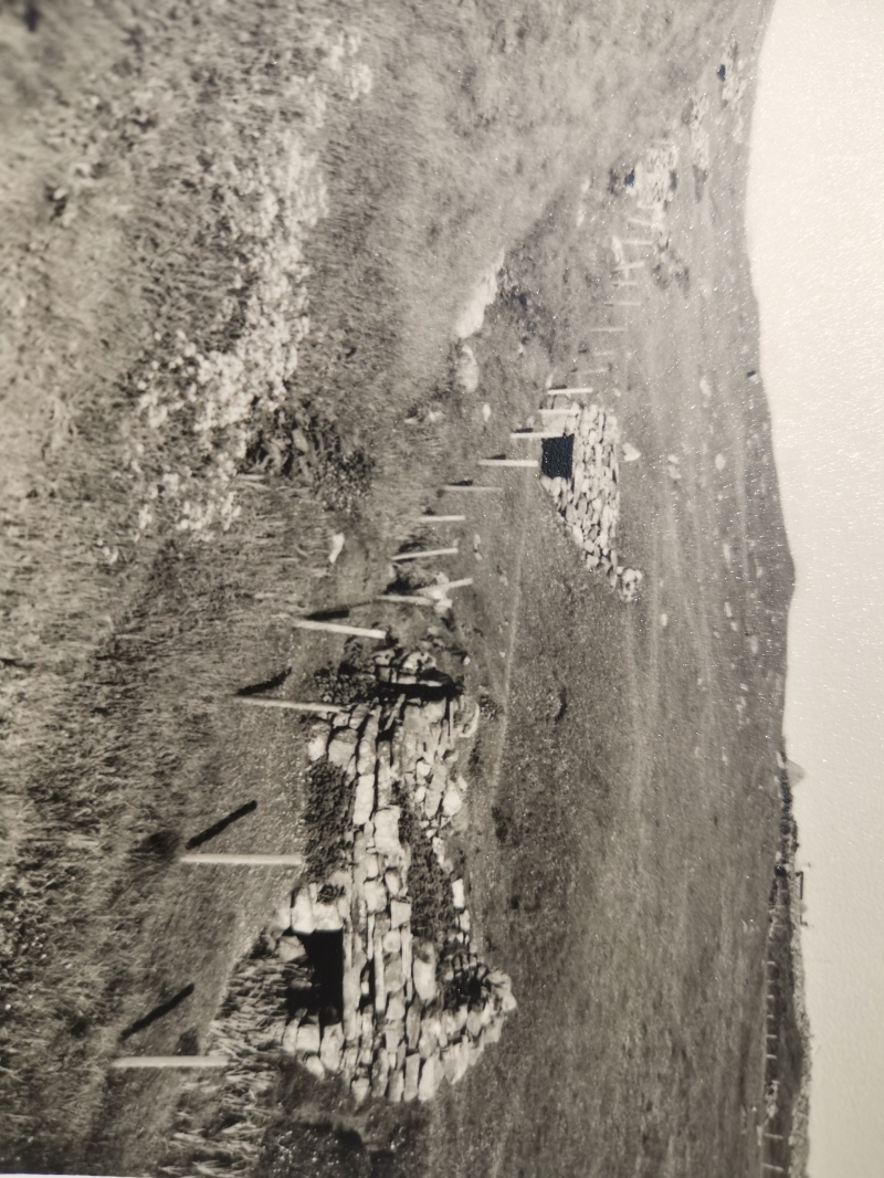
The monument comprises the remains of eleven horizontal water mills and associated lades that date to the 19th century or earlier. The mills lie alongside the Burn of Scousburgh and occur over a length of 260m, where the burn falls relatively steeply towards the sea. The condition of the mills varies. The four located furthest east, sited higher up the burn, are visible as low earthworks or piles of rubble, partly or completely turf covered. The seven lower mills, located further west, are visible as partly upstanding stone structures, some with the lower chamber visible and free of rubble, some with the walls of the upper chamber partly upstanding. Mills 10 and 11 (the mills are numbered from 1-11, beginning at the E end), located at the W end of the group, are the most complete structures, the S wall of Mill 10 standing some 2m higher than the base of the lower chamber. Most of the mills are terraced into the S side of the valley and measure about 4m by 3m (external dimensions). Where visible, the lower chambers are about 0.8m high. The lower chamber of Mill 7 has a roof of stone lintels, in which an aperture is visible. The seven mills towards the west of the series were powered via curving lades that are intermittently visible, mostly as shallow gullies. At the entry to Mill 11, the lade is clearly visible as a stone lined channel. The monument lies between 10m and 35m above sea level and extends to within 300m of the W coast of Mainland. The monument was first scheduled in 1968, but the documentation does not meet modern standards: the present rescheduling rectifies this.
The area to be scheduled is irregular on plan, to include the remains described above and an area around them within which evidence relating to the monument's construction, use and abandonment may survive, as shown in red on the accompanying map. The scheduled area extends up to but excludes a post-and-wire fence near the W end of its N boundary (starting 17m from the NW corner and running E for 105m). The scheduled area also extends up to but excludes a post-and-wire fence near the E end of the N boundary (starting at the NE corner and running W for 25m). The scheduling specifically excludes the above-ground elements of other post-and-wire fences that cross the scheduled area, the above-ground elements of the bridge over the burn and the cast iron pipe that crosses the burn, to allow for their maintenance.
Source: Historic Environment Scotland
This monument is of national importance because it has an inherent potential to make a significant addition to our understanding of the past, in particular the processing of cereal crops in the Shetland Islands. It contains well-preserved structures and buried remains that can make a significant contribution to our knowledge of the form, construction and date of horizontal water mills. Its significance is enhanced by the capacity to compare mills of potentially different date and to make comparisons with other runs of mills elsewhere in Shetland. The loss of the monument would significantly diminish our future ability to appreciate and understand the way that past agricultural communities co-operated to enable the processing of crops.
Cultural Significance
The monument's cultural significance can be expressed as follows:
Intrinsic characteristics
Horizontal water mills are sometimes called 'Norse mills', but this does not necessarily mean that they date to the Viking period. The term is used to refer to a type of water mill equipped with a water wheel that was set horizontally rather than vertically. There is evidence to suggest that this type of mill was long-lived, being constructed from the time of the Norse settlers until the 19th century. The structures have two chambers, a lower one through which the burn or lade flowed to turn a horizontal wheel, and an upper chamber housing the rotating grind stones that crushed the cereal grains to make meal or flour.
The condition of this monument varies from east to west: the four mills towards the eastern end survive largely as buried archaeological features, whereas those further west survive as mostly upstanding stone structures. However, both groups of mills now appear to be stable. Both the upstanding structures and buried remains offer potential to examine in detail the construction and form of the mills and their dating and development sequence. It is likely that the mills were not all contemporary, and that the earlier examples, probably abandoned first, lie to the east. There is potential to compare early and late mills and to assess evidence for technological change. It is notable that the mills towards the east appear to have drawn power directly from the burn, whereas those to the west were fed by a system of lades. Buried remains can reveal more about the construction and use of the lades. There is also potential that buried structures and artefacts can provide details about the operation of the mills. In 1976, a pair of stones 0.79m in diameter was noted in Mill 8, together with partial remains of the wheel, and a stone 0.69m in diameter was visible in Mill 9, on the floor of the upper chamber. In 1984, millstones were also noted in Mill 3. These and other components may still be present, obscured by soil and vegetation. Structures such as the lintels covering the under chambers of several of the mills are still visible and contain features such as the apertures through which the drive shafts passed, taking power up to the grind stones in the upper chamber.
Contextual characteristics
There is potential to compare this group of horizontal mills with other long runs of mills, such as those at Huxter and Troswick. They can also be compared with mills of different form, such as that at Quendale. There is also potential to research the mills in the context of the local settlement pattern from the Norse period until the 19th century.
Associative characteristics
The mills and lades are depicted on the Ordnance Survey 1st edition map and labelled 'mills'. Eleven mills appear to be visible on the map.
Source: Historic Environment Scotland
Bibliography
RCAHMS records the site as HU31NE 19 and HU31NE 39-48. The Shetland Amenity Trust SMR reference is MSN603 (PrefRef 603).
Source: Historic Environment Scotland
Other nearby scheduled monuments