Approximate Location Map
Large Map »
This site is entirely user-supported. See how you can help.
Latitude: 54.3251 / 54°19'30"N
Longitude: -2.7585 / 2°45'30"W
OS Eastings: 350761.72494
OS Northings: 492436.493804
OS Grid: SD507924
Mapcode National: GBR 9L5F.LB
Mapcode Global: WH82W.LKM4
Entry Name: Greenside lime kiln 480m west of Castle Howe
Scheduled Date: 20 May 2003
Source: Historic England
Source ID: 1020923
English Heritage Legacy ID: 34994
County: Cumbria
Civil Parish: Kendal
Built-Up Area: Kendal
Traditional County: Westmorland
Lieutenancy Area (Ceremonial County): Cumbria
Church of England Parish: Kendal Holy Trinity
Church of England Diocese: Carlisle
The monument includes the upstanding and buried remains of Greenside lime
kiln in Kendal. It is located beside the north side of Greenside on the
southern slopes of Kendal Fell and is the surviving one of three lime
kilns, two of which have been demolished or are no longer visible, which
are depicted on the partially revised 1912 Ordnance Survey map. The lime
kiln is a two pot two draw hole type and was used to burn limestone.
Typically the limestone was tipped into the kiln from the top then burned
using wood, coal or coke as a fuel. The resultant quicklime, also known as
birdlime or slaked lime, was then shovelled out from the draw hole at the
bottom of the kiln. Lime has many uses including spreading on
lime-deficient land to encourage plant growth, the whitewashing of walls
and ceilings of buildings, and concrete and cement production.
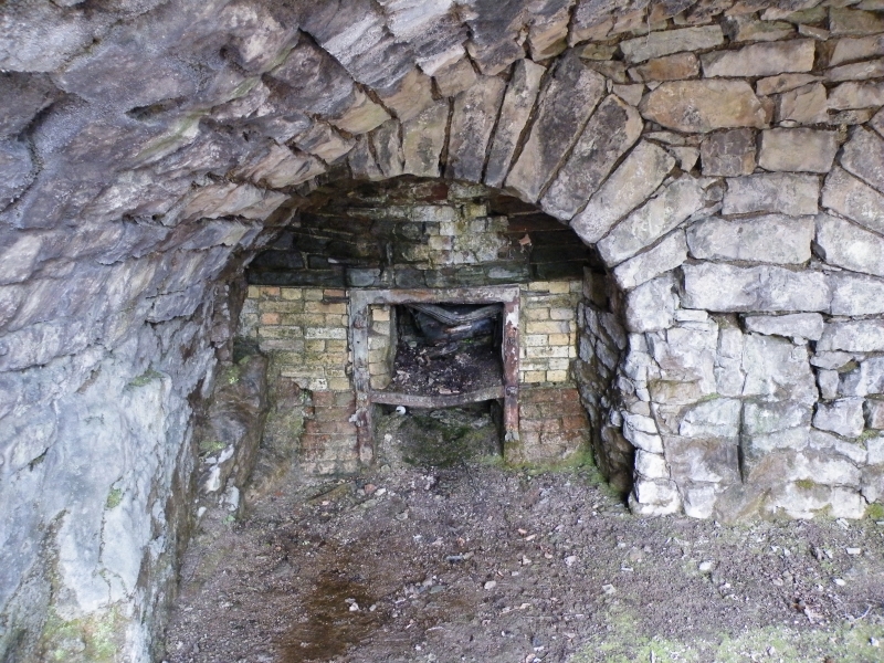
The pots are circular and although infilled appear to be lined with
refractory material. The draw holes are sheltered by a vaulted working
area about 5m in width by 3m deep and about 3m high at the centre of the
vault. The vault terminates about 1m above the ground at each side and is
fronted by an arch of roughly worked voussoirs. The draw holes are
constructed of firebrick and are virtually intact. The structure is built
into rising ground and is constructed of limestone blocks that present
sturdy walls, in places buttressed, to the east, south east and south.
These rise about 1m above the level of the charging area around the pots.
Originally the walls enclosed the whole charging area but have now been
demolished to the north and west. Two associated buildings depicted on the
1912 map lying to the west of the pots have also been demolished although
the buried remains of their foundations are expected to survive.
Although it is not known when lime burning commenced on Kendal Fell
documentary sources dated to 1715 mention a Kiln Close in the vicinity,
thus suggesting that the activity was operational by the early 18th
century, probably on a small scale and using wood as a fuel. The opening
of the Lancaster Canal in 1819 linked Kendal with the Bolton and Wigan
coalfields, transforming Kendal's economy and leading to a large increase
in population. The consequence was a building boom to meet the demands of
new business premises and housing for the workforce, which in turn
increased the demand for burned lime for builder's mortar. By 1829 six
`Lime Masters' are known to have operated on Kendal Fell.
A timber fence across the entrance to the vault sheltering the draw holes
is excluded from the scheduling, although the ground beneath is included.
MAP EXTRACT
The site of the monument is shown on the attached map extract.
Source: Historic England
Limestone or chalk has been the basic ingredient for lime mortar from at
least Roman times. Since the medieval period, lime has also been used as
agricultural fertiliser and, since the early 19th century, widely used in
a variety of other industries: as a flux in blast furnaces, in the
production of gas and oil, and in the chemical, pharmaceutical and food
industries.
The lime industry is defined as the processes of preparing and producing
lime by burning and slaking. The basic raw material for producing lime is
limestone or chalk: when burnt at high temperature (roasted or calcined),
these rocks release carbon dioxide, leaving `quicklime' which, by chemical
reaction when mixed with water (`slaking'), can be turned into a stable
powder - lime. Lime burning sites varied in scale from individual small
lime kilns adjacent to a quarry, to large-scale works designed to operate
commercially for an extended market and often associated with long
distance water or rail transport. Lime burning as an industry displays
well-developed regional characteristics, borne out by the regional styles
of East Anglia, West Gloucestershire or Derbyshire.
The form of kilns used for lime burning evolved throughout the history of
the industry, from small intermittent clamp and flare kilns, to large
continuously fired draw kilns that could satisfy increased demand from
urban development, industrial growth and agricultural improvement.
Small-scale rural lime production continued in the later 19th and 20th
centuries, but this period of the industry is mainly characterised by
large-scale production and the transfer of technologies from the cement
and other industries. The demand for mortars grew steadily during the 19th
and 20th centuries. The successful production of mortars made with
artificial cement represented an economic challenge to lime production and
gradually replaced the use of lime mortars in major construction and
engineering projects.
From a highly selective sample made at national level, around 200 lime
industry sites have been defined as being of national importance. These
have been defined to represent the industry's chronological depth,
technological breadth and regional diversity.
Despite currently being somewhat overgrown by vegetation, Greenside lime
kiln 480m west of Castle Howe survives well and is a good example of an
18th/19th century draw kiln. It is an important element in the development
of Kendal's industrial revolution.
Source: Historic England
Other
Proposal to Schedule Greenside Limekiln, Kendal, (2002)
Source: Historic England
Other nearby scheduled monuments