Approximate Location Map
Large Map »
This site is entirely user-supported. See how you can help.
Latitude: 54.3248 / 54°19'29"N
Longitude: -2.7504 / 2°45'1"W
OS Eastings: 351291.955038
OS Northings: 492394.434038
OS Grid: SD512923
Mapcode National: GBR 9L7F.BG
Mapcode Global: WH82W.QKHD
Entry Name: Castle Howe motte and bailey
Scheduled Date: 30 August 1922
Last Amended: 19 August 1994
Source: Historic England
Source ID: 1008900
English Heritage Legacy ID: 23703
County: Cumbria
Civil Parish: Kendal
Built-Up Area: Kendal
Traditional County: Westmorland
Lieutenancy Area (Ceremonial County): Cumbria
Church of England Parish: Kendal Holy Trinity
Church of England Diocese: Carlisle
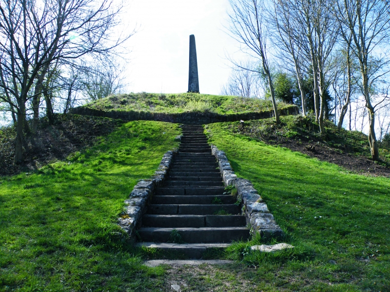
The monument includes Castle Howe motte and bailey castle in Kendal. The site
is strategically situated on a hillside spur overlooking the Kent valley and
the town of Kendal, and includes a round flat-topped motte 11m high which
measures c.18m in diameter across the summit and approximately 46m in diameter
at the base. It is surrounded on the north and south sides by a ditch up to 7m
wide by 1.5m deep which has been cut across a tongue of limestone bedrock.
Some of the upcast from this ditch has been used to form a rampart or bank up
to 5m wide and 1m high on the outside of the ditch to the north of the motte.
To the east of the motte there is a triangular bailey, known locally as
`Battle Place', which is protected by steep natural slopes on the east and
south sides.
The motte and bailey was constructed in the latter years of the 11th century
for the barony of Kendal and was occupied by Ketel, son of Eldred, in 1092.
The summit of the motte was surrounded by a breastwork, traces of which have
now disappeared above ground level. As additional protection for the bailey a
terrace was cut some 12m below the level on the steep slope to the east. This
terrace has now become a road called Garth Head. The motte and bailey was
probably abandoned about 1184 when a stone castle was built on the opposite
side of the valley.
A number of features are excluded from the scheduling; on the summit of the
motte these include an obelisk, and a bench and the concrete setting in which
the bench is fixed; elsewhere the motte retaining wall and all other walls and
railings are excluded, as are all telegraph poles and the surfaces of all the
paths; the ground beneath all these features is included.
MAP EXTRACT
The site of the monument is shown on the attached map extract.
Source: Historic England
Motte and bailey castles are medieval fortifications introduced into Britain
by the Normans. They comprised a large conical mound of earth or rubble, the
motte, surmounted by a palisade and a stone or timber tower. In a majority of
examples an embanked enclosure containing additional buildings, the bailey,
adjoined the motte. Motte castles and motte-and-bailey castles acted as
garrison forts during offensive military operations, as strongholds, and, in
many cases, as aristocratic residences and as centres of local or royal
administration. Built in towns, villages and open countryside, motte and
bailey castles generally occupied strategic positions dominating their
immediate locality and, as a result, are the most visually impressive
monuments of the early post-Conquest period surviving in the modern landscape.
Over 600 motte castles or motte-and-bailey castles are recorded nationally,
with examples known from most regions. As one of a restricted range of
recognised early post-Conquest monuments, they are particularly important for
the study of Norman Britain and the development of the feudal system. Although
many were occupied for only a short period of time, motte castles continued to
be built and occupied from the 11th to the 13th centuries, after which they
were superseded by other types of castle.
Despite landscaping of the bailey to create a public park, Castle Howe motte
and bailey survives reasonably well. It is of particular importance as being
one of a group of early post Conquest (late 11th century) motte and baileys
established along the river valleys of north west England. These sites were
all of strategic importance allowing control of movement along the river
valley. More importantly, however, was their role in imposing and
demonstrating the new post Conquest feudal order on the area.
Source: Historic England
Books and journals
Curwen, J E, 'Trans Cumb & West Antiq & Arch Soc. Extra Series' in Castles And Towers of Cumberland And Westmorland, , Vol. 13, (1913), 30-31
Other
Leach, P.E., MPP Single Monument Class Descriptions - Motte & Bailey Castles, (1988)
RCHME, Westmorland, (1936)
Source: Historic England
Other nearby scheduled monuments