Approximate Location Map
Large Map »
This site is entirely user-supported. See how you can help.
Latitude: 54.341 / 54°20'27"N
Longitude: -0.9841 / 0°59'2"W
OS Eastings: 466142.977506
OS Northings: 494414.598515
OS Grid: SE661944
Mapcode National: GBR PLK7.QM
Mapcode Global: WHF9D.V4KY
Entry Name: Two round cairns, one known as Obtrusch, 800m south west of Kneysbeck
Scheduled Date: 22 October 1973
Last Amended: 24 November 2000
Source: Historic England
Source ID: 1020376
English Heritage Legacy ID: 32695
County: North Yorkshire
Civil Parish: Farndale West
Traditional County: Yorkshire
Lieutenancy Area (Ceremonial County): North Yorkshire
Church of England Parish: Kirkbymoorside All Saints
Church of England Diocese: York
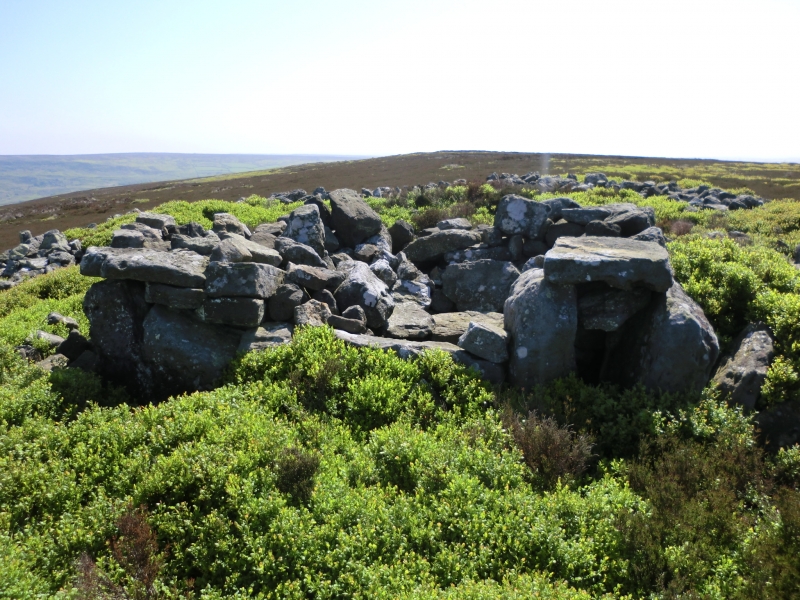
The monument includes standing and associated buried remains of a prehistoric
burial mound known as Obtrusch round cairn, along with the earthworks of a
smaller cairn centred 16m to the south east. These two cairns are sited on
Rudland Rigg, overlooking Farndale to the east. They lie just to the north
east of a large area of abandoned coal workings which are the subject of a
separate scheduling.
Obtrusch round cairn was originally known as Hobthrush Rook, Old Norse for
Hobgoblin's Heap, and was excavated in 1836 by J Philips and J Gray. Philips
published a description in 1855 together with a stylised illustration. He
noted that the cairn was a large conical heap of sandstone, several feet high
and that it had been disturbed previously. Beneath the heap was a large circle
of 25 broader and larger stones set on edge around another circle of 25 or 26
smaller edge set stones. At the centre there was an east-west orientated
rectangular cist, a box shaped grave outlined by four flagstones. However this
grave was found to be empty except for a feather. The cairn was also described
by F Elgee in 1930 by which time a drystone grouse butt had been constructed
over the north western part of the cairn.
The cairn is sited on the edge of the plateau forming Rudland Rigg, with the
ground surface dropping off to the north. It forms a skyline feature when
viewed from both Horn Ridge to the north and from much of Rudland Rigg that
extends to the north west. It is intervisible with Golden Heights and Horn Nab
round cairns and with the site of Dicken Howe, all of which lie to the north.
Obtrusch round cairn survives as a 15m diameter cairn up to 1.3m high on the
north side and 0.8m high on the uphill south side. The outer circle of stones
described by Philips can be seen to form an outer kerbing to the cairn. A
central 6m diameter area has been excavated to about 0.2m above the original
ground surface to reveal the inner circle of stones. This contains a 3m
diameter area excavated to about 0.5m below the surrounding ground surface,
which has uncovered the central cist. The largest slab in the cist measures
some 1.5m by 0.2m by over 0.3m. Spoil from the excavation appears to have been
used for the construction of the grouse butt, which is now a ruined structure
4.5m by 3.5m, with the remainder piled up around the cairn's margin. The outer
kerb beneath the grouse butt is distinctive in form with two pairs of upright
stones, each standing around 1m high and ranging between 0.25m and 0.5m wide,
flanking a recumbent slab 0.6m high and 1m long. This arrangement, which has
similarities to false portals incorporated into some chambered cairns in
Scotland, faces north west. All of the other kerb stones around the cairn are
orientated with their longest axis horizontal.
Centred 16m to the south east of Obtrusch round cairn is a second smaller
cairn. This is 6m in diameter and up to 0.4m high. It also shows evidence of
disturbance by excavation, but was not noted by Philips or Elgee. Excavation
of other examples of round cairns in the region have shown that even where no
encircling depression is discernible on the modern ground surface, ditches
immediately around the outside of the mound frequently survive as infilled
features, containing additional archaeological deposits. A margin to allow for
such infilled ditches up to 2m wide around the two cairns are thus also
included within the monument.
MAP EXTRACT
The site of the monument is shown on the attached map extract.
It includes a 2 metre boundary around the archaeological features,
considered to be essential for the monument's support and preservation.
Source: Historic England
Round cairns are prehistoric funerary monuments dating to the Bronze Age
(c.2000-700 BC). They were constructed as stone mounds covering single or
multiple burials. These burials may be placed within the mound in stone-lined
compartments called cists. In some cases the cairn was surrounded by a ditch.
Often occupying prominent locations, cairns are a major visual element in the
modern landscape. They are a relatively common feature of the uplands and are
the stone equivalent of the earthen round barrows of the lowlands. Their
considerable variation in form and longevity as a monument type provide
important information on the diversity of beliefs and social organisation
amongst early prehistoric communities. They are particularly representative of
their period and a substantial proportion of surviving examples are considered
worthy of protection.
The majority of round cairns and other burial mounds in the region were dug
into by 19th century antiquarians in search of burials and artifacts. Obtrusch
round cairn is one of the few such examples for which the identity of the
principal excavator is known and where we have any form of contemporary
documentation. Excavations in the latter half of the 20th century have shown
that round cairns typically contain archaeological information that survives
earlier digging. Secondary burials often remain in the undisturbed surrounding
part of the mound and infilled ditch and additional valuable information about
the local environment at the time of the cairn's construction can also
survive. At Obtrusch, the two rings of exposed kerb stones and the central
cist are all interesting features, demonstrating the internal structure of a
good example of a round cairn. The earthwork survival of a second smaller
cairn to the south east adds to the importance of the monument.
Source: Historic England
Books and journals
Elgee, F, Early Man in NE Yorkshire, (1930), 70-71
Phillips, J, The Rivers, Mountains and Sea Coast of Yorkshire, (1855), 210-212
Smith, M J B, Excavated Bronze Age Burial Mounds of Durham and N' land., (1994), 112
Source: Historic England
Other nearby scheduled monuments