Approximate Location Map
Large Map »
This site is entirely user-supported. See how you can help.
Latitude: 54.3194 / 54°19'10"N
Longitude: -0.8628 / 0°51'46"W
OS Eastings: 474066.405721
OS Northings: 492136.289643
OS Grid: SE740921
Mapcode National: GBR QLDH.ZC
Mapcode Global: WHF9G.QPBH
Entry Name: Ring cairn on Askew Rigg, 880m south east of Hartoft Bridge
Scheduled Date: 22 June 1973
Last Amended: 3 July 2000
Source: Historic England
Source ID: 1018977
English Heritage Legacy ID: 32656
County: North Yorkshire
Civil Parish: Hartoft
Traditional County: Yorkshire
Lieutenancy Area (Ceremonial County): North Yorkshire
Church of England Parish: Lastingham St Mary
Church of England Diocese: York
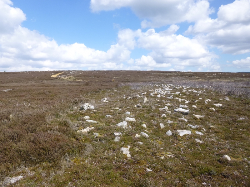
The monument includes buried and earthwork remains of a prehistoric burial
monument on Askew Rigg, 880m south east of Hartoft Bridge. It is marked as an
enclosure by the Ordnance Survey and lies 950m south west of Hartoft Bridge,
centred 24m east of the shooting track which runs down the rigg.
The ring cairn is sited on a slight natural rise on the top of the gently
sloping spine of the rigg, overlooking the River Seven to the east, the head
of Grain Beck to the west and another more prominent rise on Askew Rigg to the
south. It is not intervisible with Abraham's Hut round cairn to the north. The
ring cairn is formed by an earth and stone bank 3.5m to 4m wide and typically
0.3m high, with individual stones typically no larger than 0.4m across, mostly
smaller. This bank forms a ring 21m in diameter measured between the centres
of the bank, with a 24m external diameter. In three places around the circuit,
to the west, NNW and south east, the bank broadens inwards with 2m by 2m
spurs. There is also a 2m wide gap in the east side of the ring, which has
been interpreted as an entrance, and a lowering of the bank on the north and
south sides caused by an abandoned footpath. The interior of the ring cairn is
uneven except for an 8m by 2m, 0.1m deep hollow area extending WSW from the
south side of the centre of the ring. This is identified as the excavation
trench dug by R Hayes in 1962, who uncovered a deposit of oak charcoal and
seeds within a pit 1.2m by 0.6m by 0.75m. The small cairn of stones at the
centre of the ring cairn is considered to be a spoil heap from this
excavation. Although there is no obvious ditch visible around the ring cairn,
a 3m margin surrounding the ring cairn is included, as a number of other
examples on the North York Moors have been found to be encircled by a ditch.
These ditches can survive as infilled features, rather than as earthworks, and
will then retain additional archaeological deposits aiding our understanding
of the changing local environment.
MAP EXTRACT
The site of the monument is shown on the attached map extract.
It includes a 2 metre boundary around the archaeological features,
considered to be essential for the monument's support and preservation.
Source: Historic England
A ring cairn is a prehistoric ritual monument comprising a circular bank of
stones up to 20m in diameter surrounding a hollow central area. The bank may
be kerbed on the inside, and sometimes on the outside as well, with small
uprights or laid boulders. Ring cairns are found mainly in upland areas of
England and are mostly discovered and authenticated by fieldwork and ground
level survey, although a few are large enough to be visible on aerial
photographs. They often occur in pairs or small groups of up to four examples.
Occasionally they lie within round barrow cemeteries. Ring cairns are
interpreted as ritual monuments of Early and Middle Bronze Age date. The exact
nature of the rituals concerned is not fully understood, but excavation has
revealed pits, some containing burials and others containing charcoal and
pottery, taken to indicate feasting activities associated with the burial
rituals. Many areas of upland have not yet been surveyed in detail and the
number of ring cairns in England is not accurately known. However, available
evidence indicates a population of between 250 and 500 examples. As a
relatively rare class of monument exhibiting considerable variation in form,
all positively identified examples retaining significant archaeological
deposits are considered worthy of preservation.
The ring cairn on Askew Rigg is a well preserved example of this rare form of
monument, the small sample excavation by Hayes adding to our interpretation of
the site. It is one of a small number of ring cairns on the North York
Moors.
Source: Historic England
Other nearby scheduled monuments