Approximate Location Map
Large Map »
This site is entirely user-supported. See how you can help.
Latitude: 54.3274 / 54°19'38"N
Longitude: -0.8646 / 0°51'52"W
OS Eastings: 473940.431383
OS Northings: 493015.625275
OS Grid: SE739930
Mapcode National: GBR QLDD.MJ
Mapcode Global: WHF9G.PHHF
Entry Name: Abraham's Hut round cairn
Scheduled Date: 10 April 1967
Last Amended: 3 July 2000
Source: Historic England
Source ID: 1020378
English Heritage Legacy ID: 32655
County: North Yorkshire
Civil Parish: Hartoft
Traditional County: Yorkshire
Lieutenancy Area (Ceremonial County): North Yorkshire
Church of England Parish: Lastingham St Mary
Church of England Diocese: York
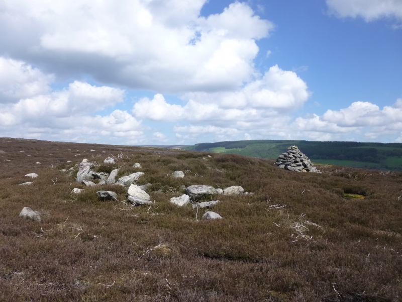
The monument includes buried and earthwork remains of a prehistoric burial
mound 1km west of Hartoft End, known as Abraham's Hut.
The round cairn is sited towards the top of the hillside overlooking the
River Seven to the west, just below the watershed for Stoney Slack to the
east. It is not intervisible with Ana Cross round barrow 1.3km up the ridge to
the north west, nor with the ring cairn 880m to the south. The cairn is mainly
stone built with a number of larger stones which would have required more than
one person to put in place. It measures 10m in diameter and 1.2m high with a
3m diameter central hollow up to 0.5m deep. The cairn has a kerbing of large
stone slabs up to 1.2m long, which is most obvious on the north western side,
and appears to be surrounded by a partly infilled ditch up to 4m wide. The
surrounding area is covered by surface stone litter, some of which has been
cleared to construct a carefully built 1.6m high modern cairn immediately to
the north east of the monument. There are also a number of small quarrying
hollows across the hillside. One of these measuring approximately 4m by 2m by
0.6m deep is cut into the line of the ditch on the south side of the round
cairn.
MAP EXTRACT
The site of the monument is shown on the attached map extract.
It includes a 2 metre boundary around the archaeological features,
considered to be essential for the monument's support and preservation.
Source: Historic England
Round cairns are prehistoric funerary monuments dating to the Bronze Age
(c.2000-700 BC). They were constructed as stone mounds covering single or
multiple burials. These burials may be placed within the mound in stone-lined
compartments called cists. In some cases the cairn was surrounded by a ditch.
Often occupying prominent locations, cairns are a major visual element in the
modern landscape. They are a relatively common feature of the uplands and are
the stone equivalent of the earthen round barrows of the lowlands. Their
considerable variation in form and longevity as a monument type provide
important information on the diversity of beliefs and social organisation
amongst early prehistoric communities. They are particularly representative of
their period and a substantial proportion of surviving examples are considered
worthy of protection.
Excavations of round cairns and barrows in the region have shown that they
demonstrate a wide range of burial rites from simple scatters of cremated
material to coffin inhumations and cremations contained in urns, typically
dating to the Bronze Age. A common factor is that these mounds were normally
used for more than one burial and that the primary burial was frequently on or
below the original ground surface, often with secondary burials located within
the body of the mound.
Abraham's Hut is a good and well preserved example of a small round cairn.
Source: Historic England
Other nearby scheduled monuments