Approximate Location Map
Large Map »
This site is entirely user-supported. See how you can help.
Latitude: 54.4059 / 54°24'21"N
Longitude: -0.5021 / 0°30'7"W
OS Eastings: 497328.304
OS Northings: 502188.867237
OS Grid: NZ973021
Mapcode National: GBR SKYH.3D
Mapcode Global: WHGBD.8J57
Entry Name: Peak alum works
Scheduled Date: 29 April 1998
Source: Historic England
Source ID: 1018146
English Heritage Legacy ID: 29550
County: North Yorkshire
Civil Parish: Fylingdales
Traditional County: Yorkshire
Lieutenancy Area (Ceremonial County): North Yorkshire
Church of England Parish: Ravenscar St Hilda
Church of England Diocese: York
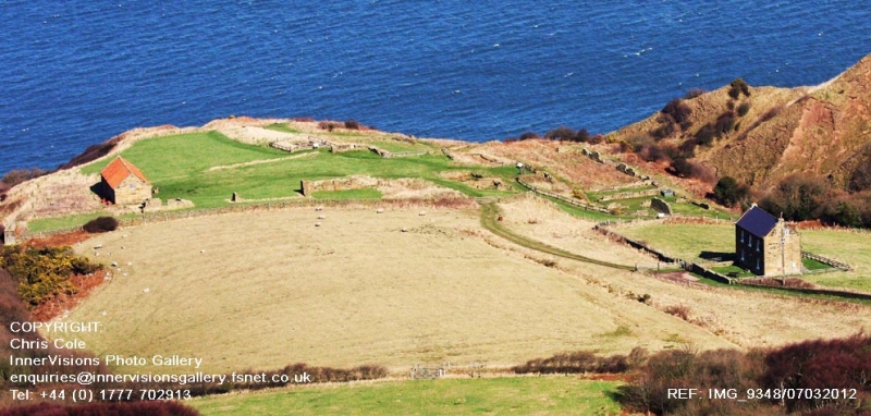
The monument includes the standing and buried remains of an alum works located
on the top of the coastal cliff on a level terrace formed by a gill to the
north and south. The remains of a wide range of processing activities survive
as buried remains, structures exposed through archaeological excavation and
standing buildings.
The first alum works was established in c.1650 and work continued there until
1862 although this was not a period of continuous activity. The bulk of the
visible remains are from the later periods of alum production in the 19th
century and represent the most sophisticated technology.
This later alum works included a range of buildings arranged north to south
located on a lower platform at the east of the site in which boiling, cooling
and roaching took place to produce the purified alum. To the west of these
buildings were reservoirs and a cistern for storing raw alum liqour (alum
shale was processed at the quarry face and the resultant material brought to
the works was known as alum liqour). On the higher ground to the west are the
remains of a grinding mill and an engine house which housed a steam engine
used to power an incline which provided access down the cliff to the shore
line. There was also a range of further service buildings to the west of the
boiling house, some of which survive as standing buildings. These include a
joiners shop, a plumbers shop, smithy and laboratory as well some accommodation
for the workforce.
At the north east of the monument part of the original access causeway to the
shoreline survives as a stone trackway extending down to the cliff edge.
The alum was produced from shale quarried from the hillside to the south
of the works.
All fences, gates, stiles and signs are excluded from the scheduling,
although the ground beneath these features is included.
MAP EXTRACT
The site of the monument is shown on the attached map extract.
Source: Historic England
Alum is a chemical used principally in the textile industry for fixing dyes.
It is not found in a natural state in Britain but can be manufactured from
some types of shale. During the medieval period in Britain alum was imported,
mostly from Italy. Domestic production began in the north of England in the
early 17th century. The industry flourished in the north for 200 years until
the mid-19th century when it was overtaken by new techniques using shale from
coal mining, whilst after 1880 aluminium sulphate replaced alum for most
industrial purposes. The last English aluminium works (at Goole) closed in
1950. Approximately 50 alum sites have been identified in England. Most were
along the Cleveland and Yorkshire coast. Other early sites are known on the
south coast, particularly in Dorset and Hampshire.
Alum works comprise two main monument types: the quarry where extraction and
initial processing took place, and the alum house where final processing took
place. Alum shale was extracted from quarries sited on steep inland hillsides
or coastal cliffs. Initial processing on the quarry floor consisted of
calcination by burning shale in clamps, and the production in settling pits of
alum liquor. The liquor was transported to processing works in sealed casks or
through wooden channels known as liquor troughs. Larger quarries possessed
inclines and haulage gear and sometimes harbour facilities. Stores, workshops
and laboratories can also survive. Evidence of secondary industries such as
epsom salts and iron silicates production is also preserved at alum works.
The alum industry was the first chemical industry in Britain. Its quarries and
works illustrate the early stages of the industry and the technological
advances through the period known as the Industrial Revolution. The alum
industry also offers important information about wider changes in social and
economic conditions during this period. The large scale of the industry's
workings also mean that its remains are today a major component of coastal
landscapes. A sample of the better preserved sites, illustrating the regional,
chronological and technological range of this class of monument, is considered
to merit protection.
The alum works at Peak survive well and significant archaeological remains
are preserved. The site has a long history of alum production and offers
important scope for the study of the development of the alum industry.
Source: Historic England
Books and journals
Marshall, G, The Ravenscar Alum Works, (1991)
Source: Historic England
Other nearby scheduled monuments