Approximate Location Map
Large Map »
This site is entirely user-supported. See how you can help.
Latitude: 50.4932 / 50°29'35"N
Longitude: -4.4554 / 4°27'19"W
OS Eastings: 225935.247863
OS Northings: 68812.973326
OS Grid: SX259688
Mapcode National: GBR NG.L7DL
Mapcode Global: FRA 17KR.G2N
Entry Name: Trethevy Quoit
Scheduled Date: 10 August 1923
Last Amended: 24 February 1992
Source: Historic England
Source ID: 1017579
English Heritage Legacy ID: 15003
County: Cornwall
Civil Parish: St. Cleer
Traditional County: Cornwall
Lieutenancy Area (Ceremonial County): Cornwall
Church of England Parish: St Cleer
Church of England Diocese: Truro
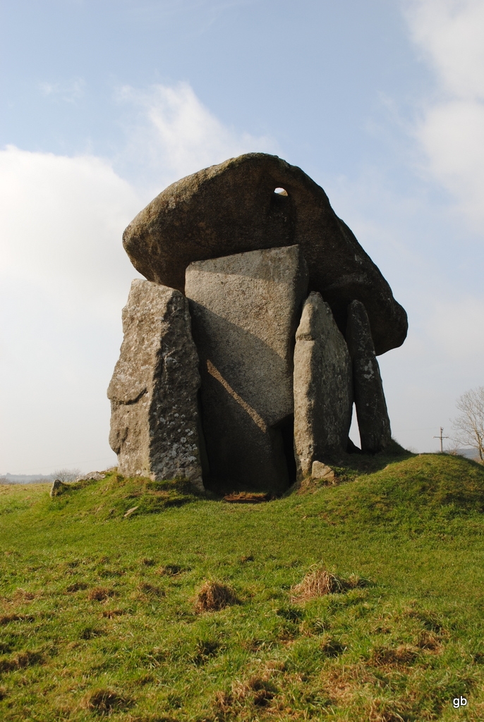
The monument includes a burial chamber of the Portal Dolmen class, dating to
the Neolithic period, and its surrounding cairn. It comprises a chamber of
large stone slabs, with a massive capstone, set in a low mound. The sub-
rectangular chamber has two overlapped side-stones to each side, a back-
stone, and a frontal slab set across the centre of the foremost side-stones
leaving an antechamber at the front. A single free-standing stone flanks the
south side of the frontal slab. The large rectangular capstone rests on the
side-stones and has a small rectangular hole cut behind its E corner. All of
the chamber slabs are in their original position and upright except the
backstone which fell inwards before 1850. The chamber is surrounded by clear
remains of a low sub-circular cairn on all sides except the area immediately
in front of the frontal slab. The cairn extends to a maximum visible
distance of 2.5m from the chamber and has an overall diameter of c.6.5m.
The monument stands near the corner of a pasture field on a gentle SE facing
slope, near the summit of a low hill overlooking the upper tributaries of the
River Seaton. The monument lies in the much-dissected landscape bordering
the S edge of the Bodmin Moor granite. This monument has been described in
antiquarian and archaeological literature since 1584 and is one of the most
frequently mentioned archaeological monuments of Cornwall. The modern
information sign and its concrete plinth are excluded from the scheduling,
though the land beneath them is included.
MAP EXTRACT
The site of the monument is shown on the attached map extract.
It includes a 2 metre boundary around the archaeological features,
considered to be essential for the monument's support and preservation.
Source: Historic England
Portal dolmens are funerary and ceremonial monuments of the early and middle
Neolithic period, the dated examples showing construction in the period
3500-2600 bc. As burial monuments of Britain's early farming communities,
they are among the oldest visible field monuments to survive in the present
landscape. Where sufficiently well-preserved, they comprise a small closed
rectangular chamber built from large stone slabs, with free-standing stones
flanking the frontal slab of the chamber. A capstone, often massive, covers
the chamber, and some show traces of a low cairn or platform around the
chamber. Some sites have traces of a kerb around the cairn and certain sites
show a forecourt area, edged by a facade of upright stones in a few burial
rites. At the few excavated sites, pits and postholes have been recorded
within and in front of the chamber, containing charcoal and cremated bone;
some chamber contents of soil and stones may be original blocking deposits.
Many portal dolmens were re-used for urned cremations, especially during the
middle Bronze Age. Only about 20 portal dolmens are known nationally,
concentrated in West Penwith, Cornwall, and the north-west Oxfordshire
Cotswolds, with a scatter between these. As one of the few surviving field
monument types of the Neolithic period, and due to their rarity, considerable
age and longevity of construction and use, all portal dolmens are considered
to be nationally important.
Trethevy Quoit is a particularly well-preserved and complete portal dolmen,
with its largely intact chamber, capstone and clear surrounding cairn. Its
good range of visible features has led to this monument often being quoted in
national descriptions of the monument class, and its prominence as a field
monument is evident from its mention in antiquarian records dating back to
1584.
Source: Historic England
Books and journals
Barnatt, J, Prehistoric Cornwall: The Ceremonial Monuments, (1982)
Lukis, W C, Borlase, W C, Prehistoric Stone Monuments of Cornwall, (1885)
Norden, J, Description of Cornwall, (1610)
Other
SMR entry for Trethevy Quoit, PRN 17337,
Source: Historic England
Other nearby scheduled monuments