Approximate Location Map
Large Map »
This site is entirely user-supported. See how you can help.
Latitude: 54.5035 / 54°30'12"N
Longitude: -0.9744 / 0°58'27"W
OS Eastings: 466513.068286
OS Northings: 512500.940336
OS Grid: NZ665125
Mapcode National: GBR PJMC.VD
Mapcode Global: WHF8N.029D
Entry Name: Two round barrows on Moorsholm Moor known as Black Howes
Scheduled Date: 6 January 1971
Last Amended: 31 January 1997
Source: Historic England
Source ID: 1015446
English Heritage Legacy ID: 28271
County: Redcar and Cleveland
Civil Parish: Lockwood
Traditional County: Yorkshire
Lieutenancy Area (Ceremonial County): North Yorkshire
Church of England Parish: Boosbeck and Lingdale
Church of England Diocese: York
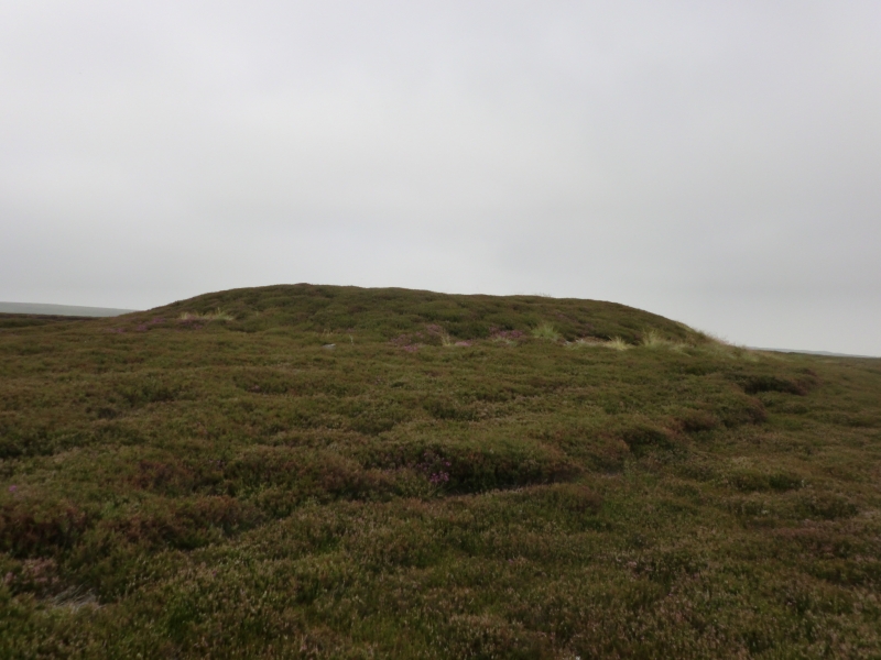
The monument includes two round barrows situated in a prominent position on
the north edge of the North York Moors.
The barrows lie adjacently, one being north west of the other. Both of the
barrows have an earth and stone mound and each was originally surrounded by a
kerb of stones which defined the barrow and supported the mound. However over
the years some of the stones have been taken away or been buried by soil
slipping off the mounds. The north western barrow stands 2m high and is 18m in
diameter. There are kerb stones visible on the south side, one with an
Ordnance Survey bench mark carved on it. The southern barrow mound is 22m in
diameter and stands 2m high and there are kerb stones visible on the south
side. Both the barrows were partly excavated in 1863 by J C Atkinson. In the
northern mound the remains of two cremation burials in urns with two pieces of
bone pins were found. The excavation of the southern mound revealed that it
was made of at least three small cairns covered by the larger earth and stone
mound and surrounded by a stone kerb. Within these cairns were found a total
of seven urns containing cremations some associated with jet beads and pottery
vessels.
The barrows lie in an area rich in prehistoric monuments including further
barrows, field systems and clearance cairns.
MAP EXTRACT
The site of the monument is shown on the attached map extract.
It includes a 2 metre boundary around the archaeological features,
considered to be essential for the monument's support and preservation.
Source: Historic England
Bowl barrows, the most numerous form of round barrow, are funerary monuments
dating from the Late Neolithic period to the Late Bronze Age, with most
examples belonging to the period 2400-1500 BC. They were constructed as
earthen or rubble mounds, sometimes ditched, which covered single or multiple
burials. They occur either in isolation or grouped as cemeteries and often
acted as a focus for burials in later periods. Often superficially similar,
although differing widely in size, they exhibit regional variations in form
and a diversity of burial practices. There are over 10,000 surviving bowl
barrows recorded nationally (many more have already been destroyed), occurring
across most of lowland Britain. Often occupying prominent locations, they are
a major historic element in the modern landscape and their considerable
variation of form and longevity as a monument type provide important
information on the diversity of beliefs and social organisations amongst early
prehistoric communities. They are particularly representative of their period
and a substantial proportion of surviving examples are considered worthy of
protection.
Despite limited disturbance, these barrows have survived well. Significant
information about the original form of the barrows and the burials placed
within them will be preserved. Evidence of earlier land use will also survive
beneath the barrow mounds.
Together with other barrows in the area they are thought to represent a
territorial marker. Similar groups of monuments are also known across the west
and central areas of the North York Moors, providing important insight into
burial practice. Such groupings of monuments offer important scope for the
study of the division of land for social and ritual purposes in different
geographical areas during the prehistoric period.
Source: Historic England
Books and journals
Elgee, F, Early Man in NE Yorkshire, (1930), 148
Smith, M J B, Excavated Bronze Age Burial Mounds in North East Yorkshire, (1995), 60
Smith, M J B, Excavated Bronze Age Burial Mounds in North East Yorkshire, (1995), 61
Spratt, D A , 'Prehistoric and Roman Archaeology in North East Yorkshire' in Prehistoric and Roman Archaeology of North East Yorkshire, (1993), 91-116
Spratt, D A , 'Prehistoric and Roman Archaeology in North East Yorkshire' in Prehistoric and Roman Archaeology of North East Yorkshire, (1993), 91-116
Source: Historic England
Other nearby scheduled monuments