Approximate Location Map
Large Map »
This site is entirely user-supported. See how you can help.
Latitude: 52.6661 / 52°39'57"N
Longitude: -2.2585 / 2°15'30"W
OS Eastings: 382616.846397
OS Northings: 307624.303173
OS Grid: SJ826076
Mapcode National: GBR 06Y.ZSW
Mapcode Global: WHBFJ.87SZ
Entry Name: White Ladies (St Leonard's) Priory
Scheduled Date: 10 May 1935
Last Amended: 15 April 1997
Source: Historic England
Source ID: 1015290
English Heritage Legacy ID: 27559
County: Shropshire
Civil Parish: Donington
Traditional County: Shropshire
Lieutenancy Area (Ceremonial County): Shropshire
The monument includes the ruined, earthwork and buried remains of the Priory
of St Leonard at Brewood, generally called White Ladies Priory, the buried
remains of the 16th century house and gardens that partly replaced it, and the
ruined and buried remains of the burial ground to the south of the priory. The
monument is situated on a gentle west facing slope south of Roman Watling
Street, some 3.5km NNE of Albrighton.
The priory was founded in the late 12th century as a house of Augustinian
nuns. It had a modest endowment and remained a small convent, however the
standing remains show a remarkably high quality of craftsmanship in their
construction and architectural detail, which had altered little since its
foundation. The house had an uneventful history, and with an annual value of
only around 17 pounds in 1535 it was dissolved the following year. Although
there were still four nuns in the house in 1538, the convent was finally
dispersed in May of that year, and the property was leased to William
Skevington of Wolverhampton while the ownership was later granted to Henry
VIII's solicitor-general, William Whorwood. However it was probably William
Skevington who built the timber-framed house which is depicted in 17th century
paintings and engravings, as White Ladies later passed to Edward Giffard,
whose first wife was Skevington's widow. It was one of their descendants who
sheltered the future Charles II at White Ladies during his flight from
Parliamentary troops in September 1651. The property subsequently followed the
descent of Boscobel House, which lies just over 1km to the north east, and
although the house at White Ladies was demolished during the 18th century its
gatehouse was still in use as a labourer's cottage in 1809. Ten years later
when much of the estate was sold, the priory site remained in the ownership of
the Fitzherbert family, and until 1844 the church was used as a Roman Catholic
burial place. The site was placed in the care of the Secretary of State in
1938 and is open to the public.
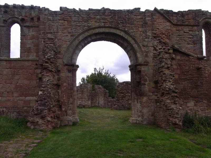
The priory church is aligned east-west and had a five-bayed, aisleless nave, a
quire, and a three-bayed, square-ended presbytery, with simple north and south
transepts. The cloister was unconventionally attached to the north wall of the
nave, in order to make use of the water supply which flowed south west through
the shallow valley bottom to the north. The medieval fabric of the priory
remains virtually unaltered by the construction of Skevington's timber-framed
house which was attached to the east end of the church. A privy garden was
created in the cloister and the house itself was walled around and provided
with a timber-framed gatehouse to the south. In the 19th century a walled
graveyard was attached to the south side of the church.
The standing remains of the priory are of coursed sandstone construction. Of
the presbytery, all but the south wall stands to its full height, and on the
north wall a row of external corbel stones indicate the position of the eaves
of its roof. Each bay had a plain round-headed window, and those in the
western bay remain intact, while a round-headed recess can be seen between the
central and eastern bays. The jambs of an inserted doorway below the central
window mark the access to a building, probably a sacristy, which was added
between the presbytery and the north transept. A fine round-headed arch leads
from the quire into the north transept, with columns of two half shafts and
angle shafts to either side. The capitals are decorated in the Romanesque
tradition characteristic of the 12th century, and the heavy but relatively
unadorned carving demonstrates a thoughtful simplicity of design carried out
with great skill. Parts of the east and west walls of the transept remain to
either side of the arch, and a fragment of string course can be seen on the
west wall. Elsewhere the foundations of the transept will survive below
ground. Most of the south transept similarly remains as buried foundations,
however the lower part of its south wall still stands, incorporated into the
wall of the 19th century graveyard, and contains the remains of a window with
a blocked recess beneath. The bays of the nave are marked externally by
pilaster buttresses on the south wall, and each bay had a window in the north
and south walls. The westernmost bay had a doorway to north and south, that in
the north wall leading into the west walk of the cloister. It has a fine
semicircular arch with cusped moulding which is more common in western France
than England. The west wall of the church has two windows. The position of the
cloister is indicated by a square platform extending from the north wall of
the nave. The absence of standing remains suggests the cloister was timber-
framed rather than stone built, and evidence for its extent will survive below
ground. Further evidence for the cloister can be seen on the outer face of the
north wall of the nave, where a weathering course at the level of the window
sills indicates the line of the roof of the south cloister alley, and a row of
corbels below it shows the position of the roof plate. The weathering turns
upwards at the east end to accommodate the roof of the east alley, and at a
higher level a second string course provides a hoodmould over the nave windows
before again sloping upwards as weathering for the north transept roof. The
priory church continued to be used for Roman Catholic burials until 1844, and
the burial ground was to the south of the nave, enclosed by a wall which
extends south from the west wall of the nave and eastwards incorporating the
south wall of the south transept and the site of the south chapel. A number of
grave covers have been found on the site, among them two dating from the late
12th to mid-13th century which now stand against the south wall of the
transept, and headstones inscribed to William Pendrill, son of the William
Penderel who sheltered Charles at Boscobel House, and his mother Joan.
To the east of the priory ruins, and now separated from them by the modern
track, are the remains of a quarry scoop which has been cut into the natural
slope, probably to provide building material for the priory. The southern end
of this hollow has subsequently been modified by the addition of an earthen
bank up to 1.2m high to form the north side of a fishpond which was fed by a
spring from the south. Part of the west side of the pond remains as a short
low stretch of bank, and would have completed what was once a roughly
rectangular hollow measuring up to c.25m south west-north east by c.33m north
west-south east. A low earthen bank continues north westwards from the back of
the pond, and at its northern end are the earthwork remains of a second,
larger, pond bay. The west arm of this bay remains as a substantial linear
earthwork, c.50m long, up to 8m wide and c.1.5m high, which turns east at its
southern end to form the beginnings of the pond's southern arm. Further east
this arm has been reduced by ploughing and is no longer visible as a surface
feature. This line of ponds, connected by the earthen bank, forms the north
eastern boundary of the priory precinct. The now straightened water course
which flows south westwards past the north end of the northern pond bay would
have provided an important resource for the monastic community and also marks
the north western edge of the precinct. The distinctly uneven ground to the
north and north west of the priory ruins indicates the presence of subsurface
foundations and rubble, the remains of the claustral buildings and ancillary
structures such as barns and guest accommodation which would have occupied the
precinct. Masonry visible in places on the path to the north east of the
church indicates possible building foundations or drain remains, perhaps for
the reredorter. The southern boundary of the precinct is no longer visible as
a surface feature, and the southern extent of the monument is drawn out to
include the extent of visible earthworks and buried features identified by
excavation.
The 16th century house which was built near the priory no longer stands,
however, 17th century engravings and paintings show it to have been a
substantial timber-framed dwelling with a hall, cross range, and a two-
storeyed porch attached to the east end of the church. The roof line of an
ancillary building attached to the west end of the church can be seen on the
outer face of the nave's west wall. The depictions indicate that the cloisters
were incorporated into a walled privy garden, and that the house itself was
surrounded by a wall with a timber-framed gatehouse opposite the porch.
Evidence for both the house and gardens will survive below ground. Excavations
to the west of the church, and the presence of brick and tile in the plough
soil, indicate the presence of post-medieval building. In common with other
high status dwellings of the period a grand approach to the house was created,
in this case by modifying the western arm of the pond bay into a causeway
which would have allowed the house to be admired from a distance. The remains
of oak stumps recently removed from the earthwork indicate it was at one time
planted to create an ornamental walkway, a tradition which may have originated
in the early post-medieval period. The current path which runs along the west
side of this causeway is later than the medieval earthworks and is probably an
extension of the southern approach to the post-medieval house.
All fences around and across the monument, and the information board, are
excluded from the scheduling, although the ground beneath them is included.
MAP EXTRACT
The site of the monument is shown on the attached map extract.
Source: Historic England
A nunnery was a settlement built to sustain a community of religious women.
Its main buildings were constructed to provide facilities for worship,
accommodation and subsistence. The main elements are the church and domestic
buildings arranged around a cloister. This central enclosure may be
accompanied by an outer court and gatehouse, the whole bounded by a precinct
wall, earthworks or moat. Outside the enclosure, fishponds, mills, field
systems, stock enclosures and barns may occur. The earliest English nunneries
were founded in the seventh century AD but most of these had fallen out of use
by the ninth century. A small number of these were later refounded. The tenth
century witnessed the foundation of some new houses but the majority of
medieval nunneries were established from the late 11th century onwards.
Nunneries were established by most of the major religious orders of the time,
including the Benedictines, Cistercians, Augustinians, Franciscans and
Dominicans. It is known from documentary sources that at least 153 nunneries
existed in England, of which the precise locations of only around 100 sites
are known. Few sites have been examined in detail and as a rare and poorly
understood medieval monument type all examples exhibiting survival of
archaeological remains are worthy of protection.
White Ladies Priory is a fine example of a 12th century Augustinian priory
church, which is unusual in being substantially unaltered since its 12th
century foundation. The standing remains retain details of their method of
construction, including the building and decorative techniques employed. The
full extent of the claustral ranges and ancillary structures will remain in
the form of post holes and as buried foundations within the precinct boundary,
and floor levels will preserve environmental and artefact evidence for the
activities which took place there. All this information will enhance our
understanding of the relationships of the priory buildings and their various
dates and functions. The subsistence and broader economic setting of this
religious community can be understood in part from the earthwork remains of
the fishponds, which will retain information relating to their method of
construction and operation, and for the conversion of the northern pond into a
causeway in the post-medieval period. The old ground surface sealed beneath
these earthwork features will retain information relating to land use
immediately prior to their construction. Further post holes, foundations and
floor levels of the 16th century house will survive below ground and will
increase our understanding of the extent and layout of the post-medieval house
and its curtilage, and evidence for the extent and design of its gardens will
also survive as buried features.
Documentary evidence provides an alternative insight into the role of the
priory in the wider picture of medieval political and social organisation in
Shropshire. The historical accounts of Charles II's escape from nearby
Boscobel House and his shelter at White Ladies further enhances interest in
the monument, and the protracted use of the Roman Catholic burial ground
illustrates the continued religious significance of the site from medieval
times through to the 19th century.
Source: Historic England
Books and journals
Weaver, O J, Boscobel House and White Ladies Priory, (1991), 38
Weaver, O J, Boscobel House and White Ladies Priory, (1991)
Weaver, O J, Boscobel House and White Ladies Priory, (1991), 35
Weaver, O J, Boscobel House and White Ladies Priory, (1993)
Morris, J A, 'Transactions of the Shropshire Archaeological Society' in White Ladies, , Vol. 48, (1934), 1-22
Other
plan, photos, Tong Archaeological Group, Trial excavations and ground survey, White Ladies Priory, 1990, (1990)
SA 01077, (1934)
Source: Historic England
Other nearby scheduled monuments