Approximate Location Map
Large Map »
This site is entirely user-supported. See how you can help.
Latitude: 52.0067 / 52°0'24"N
Longitude: -1.9013 / 1°54'4"W
OS Eastings: 406869.89265
OS Northings: 234258.30918
OS Grid: SP068342
Mapcode National: GBR 3MK.058
Mapcode Global: VHB17.0T6J
Entry Name: Village cross at Stanton
Scheduled Date: 16 November 1965
Last Amended: 18 March 1996
Source: Historic England
Source ID: 1014398
English Heritage Legacy ID: 28507
County: Gloucestershire
Civil Parish: Stanton
Built-Up Area: Stanton
Traditional County: Gloucestershire
Lieutenancy Area (Ceremonial County): Gloucestershire
Church of England Parish: Stanton and Snowshill
Church of England Diocese: Gloucester
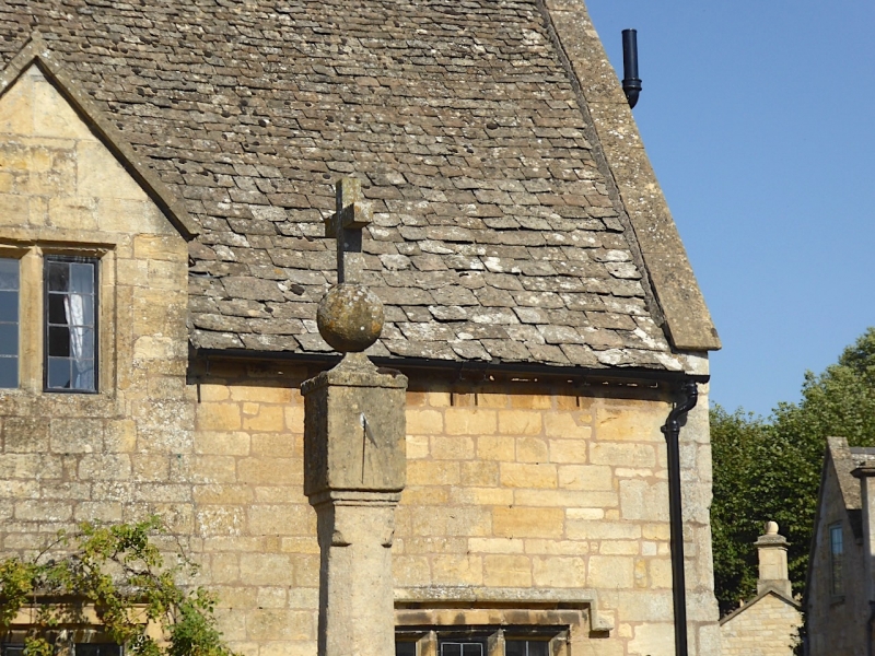
The monument includes a village cross on a three step calvary, situated on the
roadside in the village of Stanton. The cross is complete and sits on a
junction of the High Street with Church Lane.
The cross includes a three step calvary, socket stone, shaft, thickened
terminal and head. The first step of the calvary has mouldings at top and
bottom. It is 2.3m square and 0.6m high; the next step is 1.65m square and
0.2m high, and the third step is 1.15m square and 0.15m high. Above this the
socket stone is 0.6m square at its base brought up to an octagonal shape by
broaches with flat outlines. The socket stone is 0.4m high. The socket in
which the shaft is embedded is 0.3m square. The shaft, with broaches at its
base, is an octagon, c.1.4m high, surmounted by a sundial, ball and cross.
The stone blocks of the calvary and the socket are medieval, but the shaft and
head are later. The cross is Listed Grade II.
Excluded from the scheduling are the kerb stones and the metalled road surface
where they fall within the cross's protective margin, although the ground
beneath these is included.
MAP EXTRACT
The site of the monument is shown on the attached map extract.
It includes a 1 metre boundary around the archaeological features,
considered to be essential for the monument's support and preservation.
Source: Historic England
Wayside crosses are one of several types of Christian cross erected during the
medieval period, mostly from the 9th to 15th centuries AD. In addition to
serving the function of reiterating and reinforcing the Christian faith
amongst those who passed the cross and of reassuring the traveller, wayside
crosses often fulfilled a role as waymarkers, especially in difficult and
otherwise unmarked terrain. The crosses might be on regularly used routes
linking ordinary settlements or on routes having a more specifically religious
function, including those providing access to religious sites for parishioners
and funeral processions, or marking long-distance routes frequented on
pilgrimages.
Over 350 wayside crosses are known nationally, concentrated in south west
England throughout Cornwall and on Dartmoor where they form the commonest type
of stone cross. A small group also occurs on the North York Moors. Relatively
few examples have been recorded elsewhere and these are generally confined to
remote moorland locations.
Outside Cornwall almost all wayside crosses take the form of a `Latin' cross,
in which the cross-head itself is shaped within the projecting arms of an
unenclosed cross. In Cornwall wayside crosses vary considerably in form and
decoration. The commonest type includes a round, or `wheel', head on the faces
of which various forms of cross or related designs were carved in relief or
incised, the spaces between the cross arms possibly pierced. The design was
sometimes supplemented with a relief figure of Christ and the shaft might bear
decorative panels and motifs. Less common forms in Cornwall include the
`Latin' cross and, much rarer, the simple slab with a low relief cross on both
faces. Rare examples of wheel-head and slab-form crosses also occur within the
North York Moors group. Most wayside crosses have either a simple socketed
base or show no evidence for a separate base at all.
Wayside crosses contribute significantly to our understanding of medieval
religious customs and sculptural traditions and to our knowledge of medieval
routeways and settlement patterns. All wayside crosses which survive as earth-
fast monuments, except those which are extremely damaged and removed from
their original locations, are considered worthy of protection.
Despite the shaft and head being later than the calvary and socket stone, the
village cross at Stanton survives well with many of its original elements
intact in what is likely to be its original location beside the road. Its
position on the roadside makes it an imposing monument and the kerb serves as
protection from passing traffic.
Source: Historic England
Books and journals
Pooley, C, Notes on the Old Crosses of Gloucestershire, (1868), 55
Source: Historic England
Other nearby scheduled monuments