Approximate Location Map
Large Map »
This site is entirely user-supported. See how you can help.
Latitude: 54.3759 / 54°22'33"N
Longitude: -0.6325 / 0°37'57"W
OS Eastings: 488922.983239
OS Northings: 498686.523507
OS Grid: SE889986
Mapcode National: GBR SK0V.V3
Mapcode Global: WHGBJ.881P
Entry Name: Lilla Cross on Lilla Howe, Fylingdales Moor
Scheduled Date: 23 February 1933
Last Amended: 10 March 1995
Source: Historic England
Source ID: 1010076
English Heritage Legacy ID: 25655
County: North Yorkshire
Civil Parish: Lockton
Traditional County: Yorkshire
Lieutenancy Area (Ceremonial County): North Yorkshire
Church of England Parish: Fylingdales St Stephen
Church of England Diocese: York
The monument includes a standing cross on a bowl barrow on Fylingdales Moor,
both of which are included in the scheduling. The cross stands at the
junction of four medieval parishes and on the junction of the Old Salt Road
and the Pannierman's Way, both medieval trackways linking Whitby with Robin
Hood's Bay and Pickering. It also marked the bounds of an estate belonging to
Whitby Abbey in AD 1078.
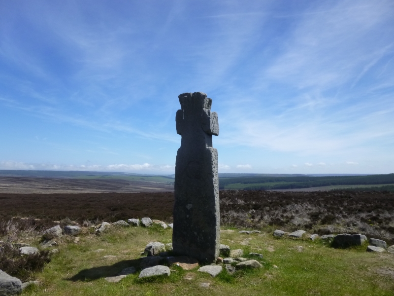
The monument comprises a standing cross which is earthfast. The cross is
complete and carved out of a single slab of local medium-grained gritstone. It
stands 2.2m high and at the base measures 0.59m wide and 0.32m thick. From
the ground the slab tapers slightly to shoulders at 1.65m surmounted by a
Maltese cross head 0.55m high and 0.49m wide. The shoulders are only 0.07m
deep.
On the north face of the cross head is a letter G and on the south face a
letter C with a cross cut beneath it. These are later additions to mark estate
boundaries. Also on the west side are some graffiti.
The cross stands in its original position although moved and re-erected in
1962. It is of a late Anglo-Saxon type, probably of the 10th century. It is
mentioned as a boundary in a Whitby charter of AD 1078-1120 granting them
lands from the Percy family. It also marks the junction of four medieval
parishes; Allerston, Fylingdales Moor, Goathland and Lockton. It stands on the
junction of two medieval trackways and therefore serves as a waymarker.
The cross stands on a bowl barrow built of large stones and earth. The barrow
was reused for burials in the Anglo-Saxon period and at least one of these
produced objects of Scandinavian type when excavated.
The barrow has been badly damaged by tourists making cairns and stone shelters
from the stones of the monument. It measures 20m in diameter and stands 1.25m
high. It has been clipped on the north side by the erosion of the footpath
beside it.
MAP EXTRACT
The site of the monument is shown on the attached map extract.
It includes a 2 metre boundary around the archaeological features,
considered to be essential for the monument's support and preservation.
Source: Historic England
A standing cross is a free standing upright structure, usually of stone,
mostly erected during the medieval period (mid 10th to mid 16th centuries AD).
Standing crosses served a variety of functions. In churchyards they served as
stations for outdoor processions, particularly in the observance of Palm
Sunday. Elsewhere, standing crosses were used within settlements as places for
preaching, public proclamation and penance, as well as defining rights of
sanctuary. Standing crosses were also employed to mark boundaries between
parishes, property, or settlements. A few crosses were erected to commemorate
battles. Some crosses were linked to particular saints, whose support and
protection their presence would have helped to invoke. Crosses in market
places may have helped to validate transactions. After the Reformation, some
crosses continued in use as foci for municipal or borough ceremonies, for
example as places for official proclamations and announcements; some were the
scenes of games or recreational activity.
Standing crosses were distributed throughout England and are thought to have
numbered in excess of 12,000. However, their survival since the Reformation
has been variable, being much affected by local conditions, attitudes and
religious sentiment. In particular, many cross-heads were destroyed by
iconoclasts during the 16th and 17th centuries. Less than 2,000 medieval
standing crosses, with or without cross-heads, are now thought to exist. The
oldest and most basic form of standing cross is the monolith, a stone shaft
often set directly in the ground without a base. The most common form is the
stepped cross, in which the shaft is set in a socket stone and raised upon a
flight of steps; this type of cross remained current from the 11th to 12th
centuries until after the Reformation. Where the cross-head survives it may
take a variety of forms, from a lantern-like structure to a crucifix; the more
elaborate examples date from the 15th century. Much less common than stepped
crosses are spire-shaped crosses, often composed of three or four receding
stages with elaborate architectural decoration and/or sculptured figures; the
most famous of these include the Eleanor crosses, erected by Edward I at the
stopping places of the funeral cortege of his wife, who died in 1290. Also
uncommon are the preaching crosses which were built in public places from the
13th century, typically in the cemeteries of religious communities and
cathedrals, market places and wide thoroughfares; they include a stepped base,
buttresses supporting a vaulted canopy, in turn carrying either a shaft and
head or a pinnacled spire. Standing crosses contribute significantly to our
understanding of medieval customs, both secular and religious, and to our
knowledge of medieval parishes and settlement patterns. All crosses which
survive as standing monuments, especially those which stand in or near their
original location, are considered worthy of protection.
Bowl barrows are funerary monuments dating from the Late Neolithic period to
the Late Bronze Age and most examples date from the period 2400-1500BC. They
were constructed as earthen or stone mounds, sometimes ditched which covered
single or multiple burials. They often occupy prominent locations and hence
have remained important elements in the landscape. Occasionally this led to
their reuse at later periods. Their considerable variation in form and
longevity as a monument type provide important information on the diversity of
beliefs and social organisation amongst early prehistoric communities. A
substantial proportion of surviving examples are considered worthy of
protection.
Lilla Cross standing cross is primarily important as a boundary marker for the
lands of the abbey at Whitby. It also may be a commemoration of an Anglo-Saxon
noble but not Lilla since the style of the cross is from the tenth century and
Lilla was a hero of the eighth. Since it was selected as the boundary of four
medieval parishes it has additional importance and helps us understand the
date of the formation of the parish system in this area. It is also a
waymarker for two medieval packhorse roads.
The barrow has been partly excavated and reveals an assemblage of Anglo-Saxon
and Viking grave goods. This shows that both the cross and the burials played
an important part in the early medieval Christian perception of the landscape.
Source: Historic England
Books and journals
Hayes, R H, Old Roads and Pannierways in North East Yorkshire, (1988), 32
Wilson, D M, Anglo-Saxon Ornamental Metalwork AD 700-1100, (1964), 12
Wilson, D M, Anglo-Saxon Ornamental Metalwork AD 700-1100, (1964), 11
Watkin, J, Mann, F, 'Medieval Archaeology' in Some Late Saxon Finds from Lilla Howe and their Context, (1981), 153-157
Watkin, J, Mann, F, 'Medieval Archaeology' in Some Late Saxon Finds from Lilla Howe and their Context, (1981), 153-157
Source: Historic England
Other nearby scheduled monuments