Approximate Location Map
Large Map »
This site is entirely user-supported. See how you can help.
Latitude: 54.3591 / 54°21'32"N
Longitude: -0.6276 / 0°37'39"W
OS Eastings: 489280.427643
OS Northings: 496820.280542
OS Grid: SE892968
Mapcode National: GBR SL11.X4
Mapcode Global: WHGBJ.BPCL
Entry Name: High Woof Howe round barrow at Derwent Head Rigg
Scheduled Date: 21 January 1970
Last Amended: 9 November 2000
Source: Historic England
Source ID: 1019375
English Heritage Legacy ID: 34174
County: North Yorkshire
Civil Parish: Lockton
Traditional County: Yorkshire
Lieutenancy Area (Ceremonial County): North Yorkshire
The monument includes a round barrow situated in a formerly prominent
position, now surrounded by trees, in Langdale Forest overlooking the head of
the River Derwent.
The barrow has an earth and stone mound which stands up to 2m high. The mound
was originally 24m in diameter, but is now oval-shaped with a maximum
dimension of 36m in a north to south direction, because of the construction of
a shooting box on the south side and augmentation by spoil from partial
excavation in the past. There are hollows caused by this past excavation in
the centre of the mound. On the south side of the central excavation hollow
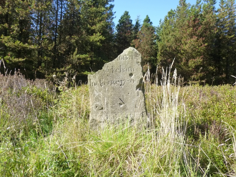
there is a boundary stone, bearing on its south eastern face the inscription
`By Order of the Commissioner of Wykeham Inclosure 1786'. The top left hand
corner of the boundary stone has been broken off, obscuring the first line of
the inscription.
The barrow lies in an area rich in prehistoric monuments including further
round barrows, field systems and clearance cairns.
MAP EXTRACT
The site of the monument is shown on the attached map extract.
It includes a 2 metre boundary around the archaeological features,
considered to be essential for the monument's support and preservation.
Source: Historic England
Round barrows are funerary monuments dating from the Late Neolithic period to
the Late Bronze Age, with most examples belonging to the period 2400-1500 BC.
They were constructed as earthen mounds, sometimes ditched, which covered
single or multiple burials. They occur either in isolation or grouped as
cemeteries and often acted as a focus of burials in later periods. Often
superficially similar, although differing widely in size, they exhibit
regional variations in form and a diversity of burial practices. There are
over 10,000 surviving examples recorded nationally (many more have already
been destroyed), occurring across most of Britain, including the Wessex area
where it is often possible to classify them more closely, for example as bowl
or bell barrows. Often occupying prominent locations, they are a major
historic element in the modern landscape and their considerable variation in
form and longevity as a monument type provide important information on the
diversity of beliefs and social organisations amongst early prehistoric
communities. They are particularly representative of their period and a
substantial proportion of surviving examples are considered worthy of
protection.
Despite limited disturbance, High Woof round barrow has survived well.
Significant information about the original form of the barrow and the burials
placed within it will be preserved. Evidence for earlier land use and the
contemporary environment will also survive beneath the barrow mound.
The barrow is one of a group of three burial monuments and such clusters
provide important insight into the development of ritual and funerary
practice during the Bronze Age. Together with other barrows in the area, it is
thought to represent a territorial marker. Similar groups of monuments are
also known across the west and central areas of the North York Moors. Such
groupings of monuments offer important scope for the study of land division
for social and ritual purposes in different geographical areas during the
prehistoric period.
Source: Historic England
Books and journals
Spratt, D A , 'Prehistoric and Roman Archaeology in North East Yorkshire' in Prehistoric and Roman Archaeology of North East Yorkshire, , Vol. 87, (1993)
Other
Craster, O E, AM 7, (1967)
Source: Historic England
Other nearby scheduled monuments