Approximate Location Map
Large Map »
This site is entirely user-supported. See how you can help.
Latitude: 53.4837 / 53°29'1"N
Longitude: -2.1804 / 2°10'49"W
OS Eastings: 388124.076076
OS Northings: 398564.008821
OS Grid: SJ881985
Mapcode National: GBR DZG.H6
Mapcode Global: WHB9H.GPYQ
Entry Name: Clayton Hall moated site
Scheduled Date: 8 January 1993
Source: Historic England
Source ID: 1009339
English Heritage Legacy ID: 22448
County: Manchester
Electoral Ward/Division: Ancoats and Clayton
Built-Up Area: Manchester
Traditional County: Lancashire
Lieutenancy Area (Ceremonial County): Greater Manchester
Church of England Parish: Clayton St Cross with St Paul
Church of England Diocese: Manchester
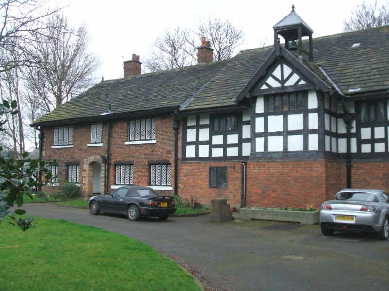
The monument is the moated site of Clayton Hall. It includes the rectangular
island which measures c.66m by 74m upon which stands the present Clayton Hall.
Access to the island is by a late medieval twin-arched stone bridge across the
moat's south-eastern arm.
Clayton was the seat of the Byron family from the late 12th to the early 17th
century, after which it passed through various families. It was the
birthplace of Humphrey Chetham, founder of Chetham's School. A late
14th/early 15th century chapel stood at the island's north-west corner until
the beginning of the 18th century and fragments of the masonry have been found
on the island from time to time. During the 15th century building expansion
took place and Clayton Hall is thought to have been quadrangular or of three
wings at this time. This hall was largely demolished and a new house built
during the 17th century. Additions to the hall were made in the 18th century
and in 1900 the house was largely restored. The late medieval bridge replaced
an earlier timber structure and was widened at the turn of the 19th century.
Clayton Hall is a Listed Building Grade II*.
Clayton Hall and its outbuildings, the bridge, all service pipes, paths,
driveways, fences, stone gateposts, a stone mounting block, ornamental stone
posts, and the works compound and its associated buildings in the island's
north-eastern corner are all excluded from the scheduling, although the ground
beneath these features is included. The surrounding moat, which has been
scoured out and concrete lined, is not included in the scheduling.
MAP EXTRACT
The site of the monument is shown on the attached map extract.
Source: Historic England
Around 6,000 moated sites are known in England. They consist of wide ditches,
often or seasonally water-filled, partly or completely enclosing one or more
islands of dry ground on which stood domestic or religious buildings. In some
cases the islands were used for horticulture. The majority of moated sites
served as prestigious aristocratic and seigneurial residences with the
provision of a moat intended as a status symbol rather than a practical
military defence. The peak period during which moated sites were built was
between about 1250 and 1350 and by far the greatest concentration lies in
central and eastern parts of England. However, moated sites were built
throughout the medieval period, are widely scattered throughout England and
exhibit a high level of diversity in their forms and sizes. They form a
significant class of medieval monument and are important for the understanding
of the distribution of wealth and status in the countryside. Many examples
provide conditions favourable to the survival of organic remains.
Despite the loss of archaeological deposits from the surrounding moat Clayton
Hall moated site survives well. Evidence of the earlier building phases of
Clayton Hall will survive on the island as will further remains of the late
14th/early 15th century chapel.
Source: Historic England
Books and journals
Farrer, W, Brownbill, J, The Victoria History of the County
Farrer, W, Brownbill, J, The Victoria History of the County
Farrer, W, Brownbill, J, The Victoria History of the County
Tindall, A S, 'Country Houses of Greater Manchester' in The Moated House, (1985)
Other
Darvill, T, MPP Single Monument Class Descriptions - Moats, (1989)
DOE, List of Buildings of Historic & Architectural Interest,
Hales, S. (Parks Manager, Man City Council), To Robinson, K.D., (1992)
SMR No. 1428/1/0, Gt Manchester SMR, Clayton Hall, (1989)
Source: Historic England
Other nearby scheduled monuments