Approximate Location Map
Large Map »
This site is entirely user-supported. See how you can help.
Latitude: 50.5132 / 50°30'47"N
Longitude: -4.0646 / 4°3'52"W
OS Eastings: 253715.38
OS Northings: 70192.668
OS Grid: SX537701
Mapcode National: GBR NZ.K5S8
Mapcode Global: FRA 27CP.Y1Z
Entry Name: Walkhampton Church House cross: a wayside cross on the east side of Church House, 650m north east of Walkhampton village
Scheduled Date: 20 August 1998
Source: Historic England
Source ID: 1009194
English Heritage Legacy ID: 24836
County: Devon
Civil Parish: Walkhampton
Traditional County: Devon
Lieutenancy Area (Ceremonial County): Devon
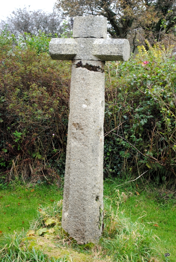
The monument includes the tall but incomplete shaft of a medieval wayside
cross of moderately fine-grained granite, set into a granite socket stone on a
grass verge on the east side of Walkhampton Church House. The cross and
socket stone were brought together in a restoration of 1984, at which time the
socket was slightly enlarged in order to accommodate the shaft. A head has
been added in the 1990s.
The total height of the shaft above the socket stone is 1.63m. The shaft
has a nearly square base, 0.37m by 0.34m. Except for the southern corner of
the shaft, where a chamfer begins 0.1m above the base, the square shaft
becomes chamfered between 0.29m and 0.38m above the base. The chamfer,
which is 0.1m-0.11m wide, continues to the broken-off top of the slightly
tapering shaft. The top the shaft is neatly square, 0.25m by 0.25m, plus
chamfers. In the centre of its top surface there is a drilled triangular hole
with rounded corners, 25mm in diameter and 45mm deep.
The western corner of the shaft has half the chamfer cut away to form vertical
fluting between points 0.67m below the top of the shaft and 0.29m above the
base.
The south east face of the shaft has four holes partially plugged with lead
and/or iron. From top to bottom the holes are: (1) square, 25mm by 25mm by
40mm maximum depth, partially plugged with lead; (2) circular, 70mm in
diameter, filled with lead and with an iron plate fastened over it; (3)
squarish, 35mm by 35mm, mostly filled with lead; (4) circular, 30mm diameter
by 40mm deep, and unfilled.
The socket stone, which is of a different type of granite to the shaft, has
an uneven top surface, and was probably never intended to be seen. Its
dimensions are 1.05m by 0.95m by 1.1m by 0.5m. Its maximum height above the
turf is 0.25m. The shaft is cemented into the socket hole.
The south west edge of the socket stone is 0.9m from the edge of the track
passing the church house, and the monument as a whole is about 5m north west
of another track which leads off at right-angles to the north east. The
monument is not in situ, as both the shaft and the socket stone have been
previously recorded in different positions in the near vicinity.
MAP EXTRACT
The site of the monument is shown on the attached map extract.
It includes a 2 metre boundary around the archaeological features,
considered to be essential for the monument's support and preservation.
Source: Historic England
Wayside crosses are one of several types of Christian cross erected during the
medieval period, mostly from the 9th to 15th centuries AD. In addition to
serving the function of reiterating and reinforcing the Christian faith
amongst those who passed the cross and of reassuring the traveller, wayside
crosses often fulfilled a role as waymarkers, especially in difficult and
otherwise unmarked terrain. The crosses might be on regularly used routes
linking ordinary settlements or on routes having a more specifically religious
function, including those providing access to religious sites for parishioners
and funeral processions, or marking long-distance routes frequented on
pilgrimages.
Over 350 wayside crosses are known nationally, concentrated in south west
England throughout Cornwall and on Dartmoor where they form the commonest type
of stone cross. A small group also occurs on the North York Moors. Relatively
few examples have been recorded elsewhere and these are generally confined to
remote moorland locations.
Outside Cornwall almost all wayside crosses take the form of a `Latin' cross,
in which the cross-head itself is shaped within the projecting arms of an
unenclosed cross. In Cornwall wayside crosses vary considerably in form and
decoration. The commonest type includes a round, or `wheel', head on the faces
of which various forms of cross or related designs were carved in relief or
incised, the spaces between the cross arms possibly pierced. The design was
sometimes supplemented with a relief figure of Christ and the shaft might bear
decorative panels and motifs. Less common forms in Cornwall include the
`Latin' cross and, much rarer, the simple slab with a low relief cross on both
faces. Rare examples of wheel-head and slab-form crosses also occur within the
North York Moors group. Most wayside crosses have either a simple socketed
base or show no evidence for a separate base at all.
Wayside crosses contribute significantly to our understanding of medieval
religious customs and sculptural traditions and to our knowledge of medieval
routeways and settlement patterns. All wayside crosses which survive as earth-
fast monuments, except those which are extremely damaged and removed from
their original locations, are considered worthy of protection.
Walkhampton Church House cross consists of the well dressed shaft of a tall
medieval cross of fine quality, lacking its head and arms. The cross is now
united with a socket stone which must once have formed part of another cross.
Although not in situ, both the shaft and socket stone are from other recorded
positions nearby.
Source: Historic England
Books and journals
Starkey, F H, Dartmoor Crosses And Some Ancient Tracks, (1989), 148
Masson Phillips, E, 'Report & Transactions of the Devonshire Association' in Supplementary Notes On The Ancient Stone Crosses Of Devon, , Vol. 111, (1979), 143
Source: Historic England
Other nearby scheduled monuments