Approximate Location Map
Large Map »
This site is entirely user-supported. See how you can help.
Latitude: 50.4909 / 50°29'27"N
Longitude: -4.032 / 4°1'55"W
OS Eastings: 255958.820394
OS Northings: 67653.187673
OS Grid: SX559676
Mapcode National: GBR Q1.SG51
Mapcode Global: FRA 27FR.R0C
Entry Name: Roman's Cross 50m west of the church
Scheduled Date: 6 October 2000
Source: Historic England
Source ID: 1009186
English Heritage Legacy ID: 24819
County: Devon
Civil Parish: Sheepstor
Traditional County: Devon
Lieutenancy Area (Ceremonial County): Devon
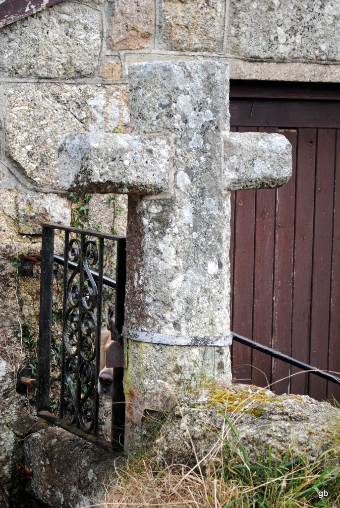
The monument, also known as Roman's Cross, includes a well-preserved wayside
cross of moderately coarse-grained granite, set on a stepped plinth outside
the western gate of Sheepstor churchyard. The cross is Listed Grade II. The
monument was restored in 1919 when new arms were cemented on and the plinth
was constructed. Before restoration the cross was in use as a rubbing post in
a nearby field. The total height of the cross above the plinth is 1.62m, and
the shaft is more or less square in section being 0.3m by 0.29m. The edges of
the shaft have a chamfer 60mm wide. The south west face of the shaft has a
hole plugged with cement 0.45m above the base. The base of the shaft is
cemented into a gap between four blocks of granite.
The north west side of the shaft has a relief Maltese cross cut into it. The
shaft of the relief cross is 60mm-80mm wide and is raised about 15mm. It
extends right to the base of the main shaft. On the south east side, a relief
cross survives only below the arms of the cross. It too extends to the base
and is about 80mm wide and is raised a maximum of about 20mm.
The head of the cross extends a maximum of 0.2m above the arms. It is
narrowest (0.24m) where it meets the arms, but at the top is 0.28m wide. The
top has been broken off on its south east side, removing the top portion of
the relief cross on this side, but has been restored with cement.
The new splayed arms, which are aligned nearly north east-south west, have
a total width of 0.68m. They extend a maximum of 0.19m from the shaft and have
a maximum depth of 0.32m on their outside edge and of 0.27m against the shaft.
The cross is set on a composite modern granite plinth in three steps, with
an additional course on the south west side. Each step is about 0.3m in
height. Each visible part of the plinth is composed of four granite blocks
which are largest at the lowest level. Some of the blocks have drill marks
and others were clearly once part of gateposts. The lowest of the top three
plinths measures 2.25m by 2.05m externally.
The whole monument is constructed on sloping ground so that while on the
north east side the base of the cross is only about 0.4m above the level of a
path leading to the churchyard gate, on the south west side, against the road,
there is a drop of about 1.4m to road level.
MAP EXTRACT
The site of the monument is shown on the attached map extract.
It includes a 2 metre boundary around the archaeological features,
considered to be essential for the monument's support and preservation.
Source: Historic England
Wayside crosses are one of several types of Christian cross erected during the
medieval period, mostly from the 9th to 15th centuries AD. In addition to
serving the function of reiterating and reinforcing the Christian faith
amongst those who passed the cross and of reassuring the traveller, wayside
crosses often fulfilled a role as waymarkers, especially in difficult and
otherwise unmarked terrain. The crosses might be on regularly used routes
linking ordinary settlements or on routes having a more specifically religious
function, including those providing access to religious sites for parishioners
and funeral processions, or marking long-distance routes frequented on
pilgrimages.
Over 350 wayside crosses are known nationally, concentrated in south west
England throughout Cornwall and on Dartmoor where they form the commonest type
of stone cross. A small group also occurs on the North York Moors. Relatively
few examples have been recorded elsewhere and these are generally confined to
remote moorland locations.
Outside Cornwall almost all wayside crosses take the form of a `Latin' cross,
in which the cross-head itself is shaped within the projecting arms of an
unenclosed cross. In Cornwall wayside crosses vary considerably in form and
decoration. The commonest type includes a round, or `wheel', head on the faces
of which various forms of cross or related designs were carved in relief or
incised, the spaces between the cross arms possibly pierced. The design was
sometimes supplemented with a relief figure of Christ and the shaft might bear
decorative panels and motifs. Less common forms in Cornwall include the
`Latin' cross and, much rarer, the simple slab with a low relief cross on both
faces. Rare examples of wheel-head and slab-form crosses also occur within the
North York Moors group. Most wayside crosses have either a simple socketed
base or show no evidence for a separate base at all.
Wayside crosses contribute significantly to our understanding of medieval
religious customs and sculptural traditions and to our knowledge of medieval
routeways and settlement patterns. All wayside crosses which survive as earth-
fast monuments, except those which are extremely damaged and removed from
their original locations, are considered worthy of protection.
Roman's Cross 50m west of the church is a striking example of a medieval
wayside cross which has been well restored, and forms a focal point outside
Sheepstor parish church. It is unusual, for western Dartmoor, in having
crosses carved in relief on it.
Source: Historic England
Other nearby scheduled monuments