Approximate Location Map
Large Map »
This site is entirely user-supported. See how you can help.
Latitude: 51.6373 / 51°38'14"N
Longitude: -3.167 / 3°10'1"W
OS Eastings: 319335
OS Northings: 193814
OS Grid: ST193938
Mapcode National: GBR HY.843M
Mapcode Global: VH6DN.233N
Entry Name: Twyn Tudor
Scheduled Date: 2 November 1933
Source: Cadw
Source ID: 2972
Cadw Legacy ID: MM035
Schedule Class: Defence
Category: Motte
Period: Medieval
County: Caerphilly (Caerffili)
Community: Pontllanfraith (Pontllan-fraith)
Traditional County: Monmouthshire
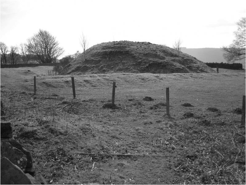
The monument comprises the remains of a motte, a military stronghold built during the medieval period. Twyn Tudor stands on level ground high on the western flank of Mynyddislwyn with expansive views to the west and close to the S of St Tudur's church, a late medieval building with presumed ore-conquest origins. It is a large and steep sided mound, 12m high with a slightly dished summit 14m in diameter. A shallow ditch surrounds the S, N and E sides, this is 5m wide and 1.5m deep, becoming 0.6m deep on the N side. The ditch is not discernible on the western side and no bailey is evident. Other than a folk tradition of a burial mound it is undocumented. It lay deep within the upland portion of the former Welsh kingdom of Gwynllwg, annexed by the Clares in the mid-13th century, although it is unclear whether it represents a short-lived relic of the initial Norman invasion of the area, a Welsh seat or a later Clare work. The ambiguous relationship of upland motte and early church is very similar to that at nearby St Illtyd, Llanhilleth (MM141).
The monument is of national importance for its potential to enhance our knowledge of medieval defensive architecture, settlement and the Norman conquest of the Gwynllwg. With the adjacent church the well-preserved monument forms an important element within the wider medieval landscape and shares group value with a series of other upland mottes in the former Welsh territories of Gwynllwg and Senghenydd. It may be expected to contain archaeological information relating to chronology, building techniques and functional detail.
The scheduled area comprises the remains described and areas around them within which related evidence may be expected to survive.
Source: Cadw
Other nearby scheduled monuments