Approximate Location Map
Large Map »
This site is entirely user-supported. See how you can help.
Latitude: 52.0095 / 52°0'34"N
Longitude: -3.8051 / 3°48'18"W
OS Eastings: 276205
OS Northings: 236104
OS Grid: SN762361
Mapcode National: GBR Y4.HDT3
Mapcode Global: VH5DX.0R8C
Entry Name: Dolau-Hirion Bridge
Scheduled Date:
Source: Cadw
Source ID: 329
Cadw Legacy ID: CM005
Schedule Class: Transport
Category: Bridge
Period: Post Medieval/Modern
County: Carmarthenshire (Sir Gaerfyrddin)
Community: Cilycwm (Cil-y-cwm)
Traditional County: Carmarthenshire
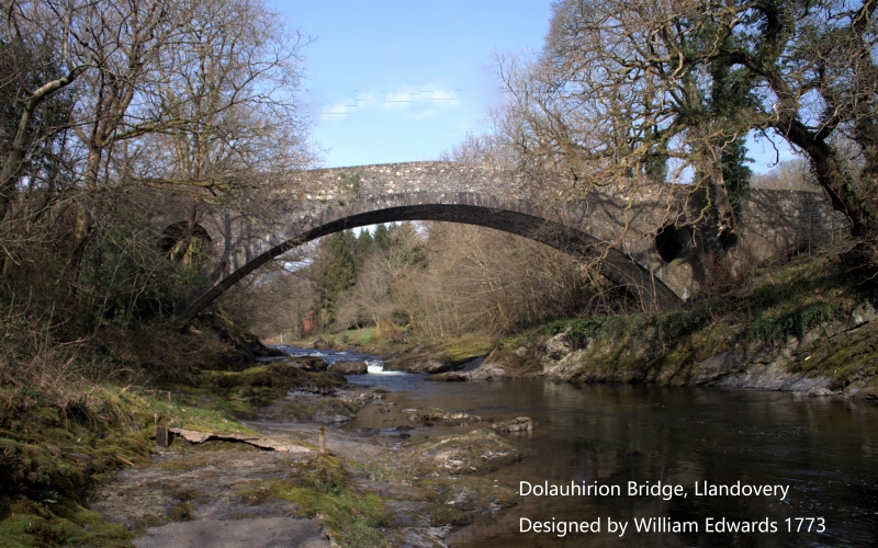
The monument consists of the remains of a bridge, dating to the post-medieval period which spans the River Cothi north of Llandovery. Built by the bridge-building Edwards family of Pontypridd it is marked ‘Thomas Edwards 1773’ on a slate coping stone in the centre of the south parapet. Both Thomas Rees writing in 1815 and Samuel Lewis in 1833 however gave the attribution to the father the Rev. William Edwards; it has the weight-reducing pierced spandrels introduced by him at Pontypridd in 1756. The bridge has a single broad elliptical arch of fine coursed masonry rising high from natural rock abutments to a thin crown with a span of c 30m and a carriageway width of c 4 metres with parapets. The arch and piercings have large cut stone voussoirs. The parapets are of a cruder masonry and have slab coping stones.
The monument is of national importance for its potential to enhance our knowledge of medieval and post-medieval construction techniques and transportation systems. It retains significant archaeological potential, with a strong probability of the presence of associated archaeological features and deposits. The structure itself may be expected to contain archaeological information concerning chronology and building techniques.
The scheduled area comprises the remains described and areas around them within which related evidence may be expected to survive.
Source: Cadw
Other nearby scheduled monuments