Approximate Location Map
Large Map »
This site is entirely user-supported. See how you can help.
Latitude: 52.0461 / 52°2'46"N
Longitude: -4.6877 / 4°41'15"W
OS Eastings: 215784
OS Northings: 242046
OS Grid: SN157420
Mapcode National: GBR CY.F9WR
Mapcode Global: VH2MV.PTNT
Entry Name: Castell Pen-yr-Allt
Scheduled Date:
Source: Cadw
Source ID: 3702
Cadw Legacy ID: PE169
Schedule Class: Defence
Category: Castle
Period: Medieval
County: Pembrokeshire (Sir Benfro)
Community: Cilgerran
Traditional County: Pembrokeshire
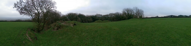
The monument comprises the remains of a motte and bailey castle a military stronghold built during the medieval period though located on the site of an earlier Iron Age promontory fort. A motte and bailey castle comprises a large conical or pyramidal mound of soil or stone (the motte) surrounded by, or adjacent to, one or more embanked enclosures (the bailey). Both may be surrounded by wet or dry ditches and could be further strengthened with palisades, revetments, and/or a tower on top of the motte. The bailey, an area of c 60m north to south by 50m east to west, is enclosed by a bank and ditch; the; rock cut ditch, about 5m to 6m wide is evident on all sides except the north. The bank stands up to 7m above it but is absent on the west where there are the low remains of a stone wall along this side or possible stone building. There is a counterscarp to the ditch on the southern side. The motte is located in the southern part of the interior, it is 20m in diameter and 4m high, the collapsed remains of a masonry tower are on top. Geophysical survey undertaken in 2017 demonstrated that complex multivallate defences exist around the north side of the enclosure, comprising both ditches and stonework. A ditch was revealed curving around the northern side of the motte some 20m from its base together with a buried around the base. Buried walling was revealed along both the southeast and southwest edges of the enclosure. There are other probable areas of buried stonework, and probable in-filled pits. The possible footings of earlier roundhouse were detected to the north of the motte.
The monument is of national importance for its potential to enhance our knowledge of medieval and later prehistoric defensive organisation. The well-preserved monument forms an important element within the wider medieval and pre-historic context and the structure itself may be expected to contain archaeological information relating to chronology, building techniques and functional detail.
The scheduled area comprises the remains described and areas around them within which related evidence may be expected to survive.
Source: Cadw
Other nearby scheduled monuments