Approximate Location Map
Large Map »
This site is entirely user-supported. See how you can help.
Latitude: 56.6483 / 56°38'54"N
Longitude: -2.6075 / 2°36'26"W
OS Eastings: 362847
OS Northings: 750891
OS Grid: NO628508
Mapcode National: GBR VT.WBBZ
Mapcode Global: WH8RV.X5J4
Entry Name: Braikie Castle, castle 65m S of Wester Braikie
Scheduled Date: 10 June 1920
Last Amended: 17 March 2015
Source: Historic Environment Scotland
Source ID: SM166
Schedule Class: Cultural
Category: Secular: castle
Location: Kinnell
County: Angus
Electoral Ward: Arbroath West, Letham and Friockheim
Traditional County: Angus
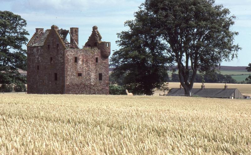
The monument is the remains of Braikie Castle, a late 16th-century tower house. The tower is L-shaped in plan with four storeys and a garret. It survives to wall-head height and fragments of the roof timbers and slate tiles survive on the N and NW side. The castle stands within a grass field, surrounded by agriculturally rich land, on gently sloping ground at around 75m above sea level, overlooking Gighty Burn to the S. The monument was last scheduled in 1977, but the documentation did not meet modern standards: the present amendment rectifies this.
The castle is constructed of sandstone rubble with dressed quoins and bonded with lime mortar. Key features of the tower include a stair-turret rising above first-floor level in the re-entrant angle and a corbelled angle-turret at the SW gable; a heraldic panel above the door and a surviving iron yett; a tall chimney-stack rising above the stair turret; and a large number of wide-splayed gun-loops (one for almost every window). The main stair rises to the first floor, while access to the upper floors is provided by the stair turret. The ground floor has two vaulted cellars and what was probably a small guardroom beneath the main stair. The hall was situated on the first floor and a private stair leads to the wing above and a private chamber for the laird. The heraldic panel above the door shows a shield with the letters 'T F' and the date 1581; it depicts the arms of the Fraser clan and the motto 'soli deo confido'.
The scheduled area is rectangular on plan, measuring 30m WSW-ENE by 25m transversely, to include the remains of the castle and an area around it within which evidence for the monument's construction, use and abandonment is expected to survive, as shown in red on the accompanying map.
Source: Historic Environment Scotland
The monument is of national importance as a well-preserved example of a late 16th-century tower. Braikie Castle survives complete to wall-head height and is an impressive example of its class. It has high potential to contribute to our understanding of late medieval and post-medieval domestic fortified dwellings: their architecture, construction, maintenance, development and abandonment. There is significant potential for the survival of important archaeological remains, including artefactual and palaeoenvironmental evidence and the remains of additional structures within and around the tower, which can enhance our understanding of how such buildings functioned, the daily life of the inhabitants and contemporary society and economy. There is high potential to analyse the construction and development of the castle by recording and analysis of the upstanding fabric. The monument occupies a prominent position and is an attractive feature within the local landscape today. The loss of the monument would diminish our ability to understand the form, function and character of late medieval and post-medieval towers in eastern Scotland and further afield.
Source: Historic Environment Scotland
Bibliography
RCAHMS records the monument as NO65SW 20. The Angus SMR records the monument as NO65SW 0020.
ReferencesMacGibbon, D and Ross, T 1887-92, The castellated and domestic architecture of Scotland from the twelfth to the eighteenth centuries, 5v, 2, 74-7.
RCAHMS 1978, The Royal Commission on the Ancient and Historical Monuments of Scotland. The archaeological sites and monuments of Lunan Valley, Montrose Basin, Angus District, Tayside Region, The archaeological sites and monuments of Scotland series no 4, Edinburgh, 30, no 256. Tranter, N 1962-70, 'The fortified house in Scotland', Edinburgh, 4, 99-100.
Source: Historic Environment Scotland
Other nearby scheduled monuments