Approximate Location Map
Large Map »
This site is entirely user-supported. See how you can help.
Latitude: 60.7187 / 60°43'7"N
Longitude: -0.9498 / 0°56'59"W
OS Eastings: 457402
OS Northings: 1204412
OS Grid: HP574044
Mapcode National: GBR S00D.TML
Mapcode Global: XHF7B.2V27
Entry Name: Underhoull, broch, Iron Age and Norse farmsteads and field systems
Scheduled Date: 24 May 1934
Last Amended: 31 October 2012
Source: Historic Environment Scotland
Source ID: SM2087
Schedule Class: Cultural
Category: Prehistoric domestic and defensive: broch; Secular: house
Location: Unst
County: Shetland Islands
Electoral Ward: North Isles
Traditional County: Shetland
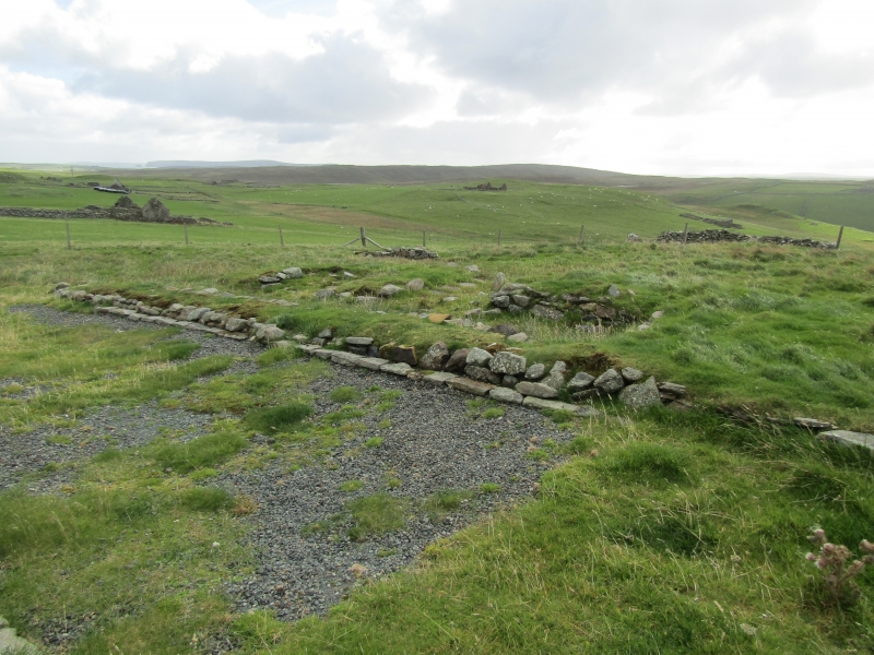
The monument comprises the remains of a broch of Iron Age date, built probably between 500 BC and AD 200, within an extensive field system, which incorporates a Norse longhouse 90m east of the broch and a farmstead of Iron Age and Norse date 140m southwest of the broch. The monument lies in open pasture overlooking Lunda Wick. The broch occupies a prominent position at the top of a slope, at around 35m above sea level, while the Iron Age and Norse farmstead lies down the slope, some 75m from the shore.
The broch is visible as a substantial turf-covered mound, 18m across and up to 2m high, surrounded by two concentric earthen ramparts with an intervening ditch. Two rectangular turf-covered stone structures, measuring 13m by 7.5m and 9m by 6.5m respectively, directly abut the outer bank on the east. The Norse longhouse east of the broch has been partly excavated and consolidated, and consists of a bipartite main house measuring 20m by 7m aligned WNW-SSE, with an adjoining annex on the southwest wall. The Iron Age and Norse farmstead southwest of the broch is primarily visible as the remains of a Norse longhouse measuring 18m by 6m NW-SE, partly dug into the hillside. Its end walls are rounded and the overall plan is boat-shaped. Two later outhouses adjoin this structure. The longhouse overlies the partly excavated remains of early Iron Age and broch-period huts. The field system mainly comprises a series of conjoined rectilinear enclosures defined by low earthen banks, the majority of which run down slope from the vicinity of the broch to the cliffs overlooking Lunda Wick. However, a fragmentary curvilinear boundary lying upslope some 40m north and east of the broch appear to respect the broch and may be contemporary with it. The Norse longhouse east of the broch appears to be contained within a sub-rectangular enclosure.
The broch was first scheduled in 1934, but the documentation does not meet modern standards and the scheduling did not include the field system or the other settlements: the present rescheduling rectifies this.
The area to be scheduled includes the remains described above and an area around them within which evidence relating to the monument's construction, use and abandonment may survive, as shown in red on the accompanying map. The above-ground elements of the existing post-and-wire fences are excluded from the scheduling to facilitate maintenance.
Source: Historic Environment Scotland
Cultural Significance
The monument's cultural significance can be expressed as follows:
Intrinsic characteristics
The broch survives in a collapsed condition, although the substantial remains are clearly indicative of broch morphology. It is highly probable that the lower courses of the broch survive beneath the ground surface. Future archaeological investigation of buried remains may allow researchers to record the foundations and lower courses of the broch and to examine layers formed during its occupation. The defences are impressive: in places, the ramparts stand up to 3m higher than the base of the possibly rock-cut ditch. The field system, the Norse longhouse and the Iron Age and Norse farmstead represent a palimpsest of land-use in the vicinity of the broch over a period of 1,000 years or more. The two settlements have been partly archaeologically excavated, and the latter site may have been occupied contemporaneously with the broch. It was abandoned by its occupants prior to reoccupation of the site by Norse settlers. Excavation of parts of the large sub-rectangular enclosure that surrounds the broch and the Norse longhouse has revealed indications of Iron Age construction. The date of the rectilinear field system between the broch and the sea is not known, and there is considerable potential to enhance understanding of the use and function of these fields and the daily lives of the people who farmed them. There is high potential for the recovery of artefacts and ecofacts that may illuminate the diet, economy and social status of the people living in this area, and the extent to which this varied over time. There is potential to date the construction of the broch and to compare this with the date of the rampart defences and other elements in the landscape.
Contextual characteristics
This broch is one of over 130 brochs known in Shetland. It has the potential to enhance our understanding of the relationship between brochs, the extent to which they were contemporary, and their relationship with other contemporary settlement types and with the wider landscape. Brochs have been viewed as having a defensive or offensive function, or simply as being the prestige dwellings of an elite keen to display its status. The buried remains at Underhoull have high potential to help address these questions and may provide insights into the nature and use of these structures and the landscape immediately around them. There is also potential for this monument to contribute to our understanding of how broch sites might have been reused in later periods. The two stone structures immediately adjacent to the broch may be contemporary or later, and the broch sits within a complex field system of varying dates.
The Iron Age and Norse farmstead southwest of the broch is one of a small number of proven examples of reuse of a Shetland settlement over time, and the later outhouses may also point to reuse in the medieval or later periods. As such, this site retains considerable potential to enhance our understanding of the archaeology of Shetland and Scotland. The other excavated Norse longhouse retains unexcavated deposits, which may reveal further information regarding use of the site prior to, during and succeeding the Norse occupation. The field systems in the vicinity of the broch appear to be of Iron Age and later date. Some of these features may be contemporary with the broch, while others are likely to relate to the two Norse longhouses. Such well-preserved field systems are rare in a Scottish or Shetland context, and have high potential to provide insights into agricultural practice and management of the landscape in the Iron Age and Norse periods, as well as identifying evidence of cultural change associated with the Norse arrival in the Northern Isles.
Associative characteristics
The broch is depicted on the Ordnance Survey first edition map and labelled 'Brough'.
National Importance
This monument is of national importance because it has an inherent potential to make a significant addition to our understanding of the past, in particular of Iron Age and Norse Shetland, the role and function of brochs, their relationship to other types of Iron Age settlement, and the reuse of earlier sites by Norse and later settlers. The monument offers high potential to study the relationship between the broch, its defences, the Iron Age settlement and the field system. It also offers high potential to study the relationship between the Norse farmsteads, the degree of continuity or change in culture, economy and farming practices from the Iron Age through to the Norse period, and the impact on the wider settlement pattern of Unst. The loss of the monument would significantly diminish our future ability to appreciate and understand Iron Age and Norse settlement in the Shetland Islands.
Source: Historic Environment Scotland
Bibliography
References
Bond, J & Turner, V 2007, Underhoull Upper House, Westin, Shetland (Unst parish), excavation, Discovery and Excavation in Scotland 8.
Bond, J, Larson, A and Turner, V 2008 'Hamar, Belmont and Underhoull, Shetland (Unst parish), excavation', Discovery and Excavation in Scotland, 9.
Mackie, E W 2002, The roundhouses, brochs and wheelhouses of Atlantic Scotland c.700BC-AD500: architecture and material culture, Part 1: The Orkney and Shetland Isles. BAR British Series 342: Oxford. 57.
RCAHMS, 1946, The Royal Commission on the Ancient and Historical Monuments of Scotland. Twelfth report with an inventory of the ancient monuments of Orkney and Shetland, 3v Edinburgh. 133.
Small, A. 1964-66, Excavations at Underhoull, Unst, Shetland. Proceedings of the Society of Antiquaries of Scotland, 98, 225-48.
Source: Historic Environment Scotland
Other nearby scheduled monuments