Approximate Location Map
Large Map »
This site is entirely user-supported. See how you can help.
Latitude: 57.6337 / 57°38'1"N
Longitude: -3.5668 / 3°34'0"W
OS Eastings: 306545
OS Northings: 861501
OS Grid: NJ065615
Mapcode National: GBR K8KK.2VQ
Mapcode Global: WH5H5.5DS7
Entry Name: Kinloss Abbey
Scheduled Date: 30 April 1920
Last Amended: 10 January 1997
Source: Historic Environment Scotland
Source ID: SM1227
Schedule Class: Cultural
Category: Ecclesiastical: abbey; Secular: house
Location: Kinloss
County: Moray
Electoral Ward: Forres
Traditional County: Morayshire
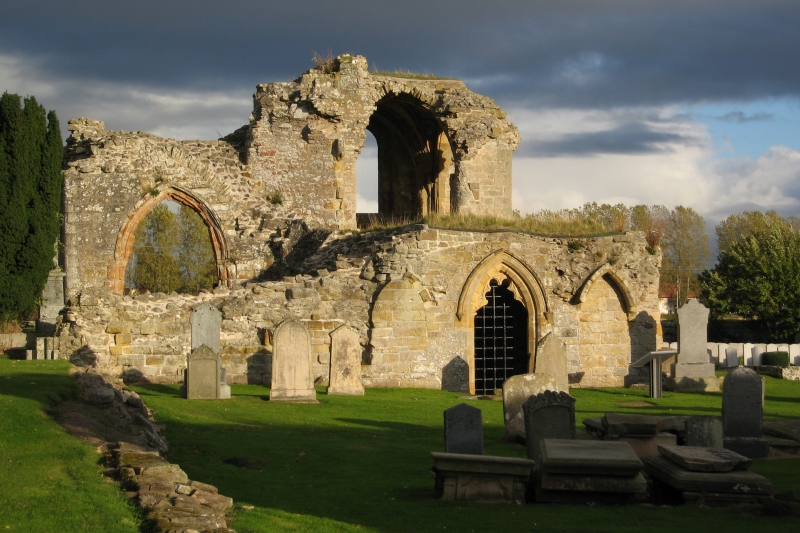
The monument comprises the remains of Kinloss Abbey which was established by David I in 1150 or 1151 as a daughter house of Melrose. The buildings were greatly added to by Robert Reid (later to become bishop of Orkney), during whose abbacy from 1528 onwards the abbot's lodging was built at the south end of the east range. The abbey was erected into a temporal lordship in 1601, and in 1651-2 the owners, the Brodies of Lethen, sold much of the stone for the the citadel in Inverness. The site is now a graveyard.
The remains of the medieval buildings are still much as they were when they were described by MacGibbon and Ross in 1896. The bases of some pillars and part of the walling of the church are now exposed and much of its outline can be conjectured, indicating a building some 52m east-west and about 35m north-south across the transepts. The south transept chapel, slype and north wall of the chapter house are still standing, as are parts of the south and west walls of the cloister. To the south of the cemetery wall stand the remains of the abbot's house.
Kinloss Abbey was scheduled in 1920, but this was not properly recorded, and the present proposal rectifies this omission and extends the protected area. The area now to be scheduled comprises the western part of the cemetery and its enclosure wall together with a fenced annexe on the south containing the abbot's house, representing an area measuring overall some 88m ESE-WNW by 100m NNW-SSE, as shown in red on the accompanying map extract.
Source: Historic Environment Scotland
The monument is of national importance as representing the remains of a Cistercian abbey whose history is well documented. Its standing remains contribute to our understanding of medieval ecclesiastical and domestic architecture in general and that of the Cistercians in particular, while its below-ground remains have the potential through excavation to add significantly to our knowledge of medieval art, architecture, material culture and monastic life.
Source: Historic Environment Scotland
Bibliography
The monument is recorded by RCAHMS as NJ 06 SE 2.
Anon. (1798), Survey of the Province of Moray, 73-6.
HB List: Kinloss Parish, item 25.
MacGibbon, D. and Ross, T. (1896), The Ecclesiastical Architecture of Scotland, I (Edinburgh), 417-21.
New Statistical Account, (1842), XIII, 206.
Stuart, J. (1881) Records of the Monastery of Kinloss.
Source: Historic Environment Scotland
Other nearby scheduled monuments