Approximate Location Map
Large Map »
This site is entirely user-supported. See how you can help.
Latitude: 57.6157 / 57°36'56"N
Longitude: -3.5977 / 3°35'51"W
OS Eastings: 304651
OS Northings: 859534
OS Grid: NJ046595
Mapcode National: GBR K8HL.DPQ
Mapcode Global: WH5H4.QV03
Entry Name: Sueno's Stone
Scheduled Date: 18 August 1882
Last Amended: 3 March 1999
Source: Historic Environment Scotland
Source ID: SM90292
Schedule Class: Cultural
Category: Crosses and carved stones: symbol stone
Location: Rafford
County: Moray
Electoral Ward: Forres
Traditional County: Morayshire
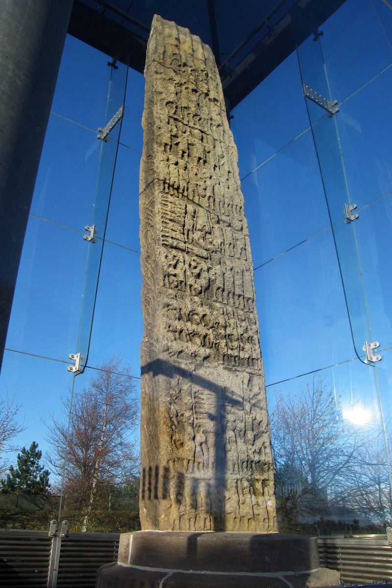
The monument comprises a cross-slab dating to the late 1st millennium AD. It is in the care of the Secretary of State for Scotland and is being re-scheduled to clarify the extent of the protected area.
The monument stands within a glass canopy at around 20m OD. It comprises Sueno's Stone, the tallest and most complex piece of early medieval sculpture in Scotland. It is composed of grey sandstone and measures about 7m high, 1.2m wide and about 40cm thick. The W face bears a relief carving of a ring-headed cross, the shaft of which is filled with interlace spiral knotwork. Below the cross are two facing bearded figures, both with smaller attendants behind. The sides of the slab are intricately carved, most notably on the upper half of the S side, where a number of small male figures occupy a vine scroll. The E face of the slab is divided into four unequal panels which can be interpreted as a heroic narrative reading from top to bottom. The top panel depicts a number of horsemen, possibly a leader and his guard arriving for battle. The great central panel is divided into three sections. The top section depicts a scene of battle with the combatants fighting on foot. The middle section shows a besieged stronghold, to the left of which a number of headless corpses are depicted. This scene can be interpreted as an account of the fate of the defeated defenders of the besieged stronghold. The bottom section of the great central panel depicts a group of horsemen fleeing from a group of infantry. The lower two panels of the E face appears to show the final defeat of the defending army. The first depicts piles of headless corpses and severed heads, and the bottom panel shows the dispersal of the defeated army.
Although the stone is traditionally associated with Swein Forkbeard, who attacked London in 994, there appears to be no evidence to support any such connection. It seems that it was already standing by c.1590, the date of Timothy Pont's Map; but it is not known precisely when, why or by whom it was originally erected.
The area proposed for scheduling comprises the stone and an area around it within which related material may be expected to be found. It is rectangular, measuring approximately 76m on the NW, 33m on the NE, 79m on the SE and 30m on the SW, as marked in red on the accompanying map extract.
Source: Historic Environment Scotland
The monument is of national importance because of its contribution to our understanding of early medieval sculpture, religion, military techniques and material culture, and the potential of the area surrounding the stone to increase our understanding still further through archaeological excavation. The importance of the site is reflected in it being chosen as a property in care and by its inclusion in the first Schedule of ancient monuments drawn up in 1882.
Source: Historic Environment Scotland
Bibliography
The monument is recorded by RCAHMS as NJ 05 NW 1.
Bibliography:
Cross, M. (1994)Bibliography of Monuments in the Care of the Secretary of State for Scotland, 566'7. Glasgow.
McCullagh, R. P. J.(1995)Excavations at Sueno's Stone, Forres, Moray. Proc Soc Antiq Scot 125: 697'718.
Shepherd, I. (1986)Exploring Scotland's Heritage, Grampian. HMSO; Edinburgh.
Southwick, L. (1981)The so'called Sueno's Stone at Forres. Moray District Libraries Publications. Elgin.
Historic Environment Scotland Properties
Sueno's Stone
https://www.historicenvironment.scot/visit-a-place/places/suenos-stone
Find out more
Source: Historic Environment Scotland
Other nearby scheduled monuments