Approximate Location Map
Large Map »
This site is entirely user-supported. See how you can help.
Latitude: 55.2806 / 55°16'50"N
Longitude: -4.7216 / 4°43'17"W
OS Eastings: 227234
OS Northings: 601874
OS Grid: NS272018
Mapcode National: GBR 45.9K3D
Mapcode Global: WH2QM.FJVN
Entry Name: Dalquharran Castle (Old Castle)
Scheduled Date: 28 June 1935
Last Amended: 21 May 2002
Source: Historic Environment Scotland
Source ID: SM316
Schedule Class: Cultural
Category: Secular: castle
Location: Dailly
County: South Ayrshire
Electoral Ward: Girvan and South Carrick
Traditional County: Ayrshire
The monument comprises the remains of the old castle of Dalquharran, surviving as substantial standing structures and as buried archaeology, together with an area enclosing the outer defences and infrastructure. The monument was originally scheduled in 1935. It is being rescheduled to extend protection to the whole of the archaeologically sensitive area, including important remains outwith the walls of the main tower.
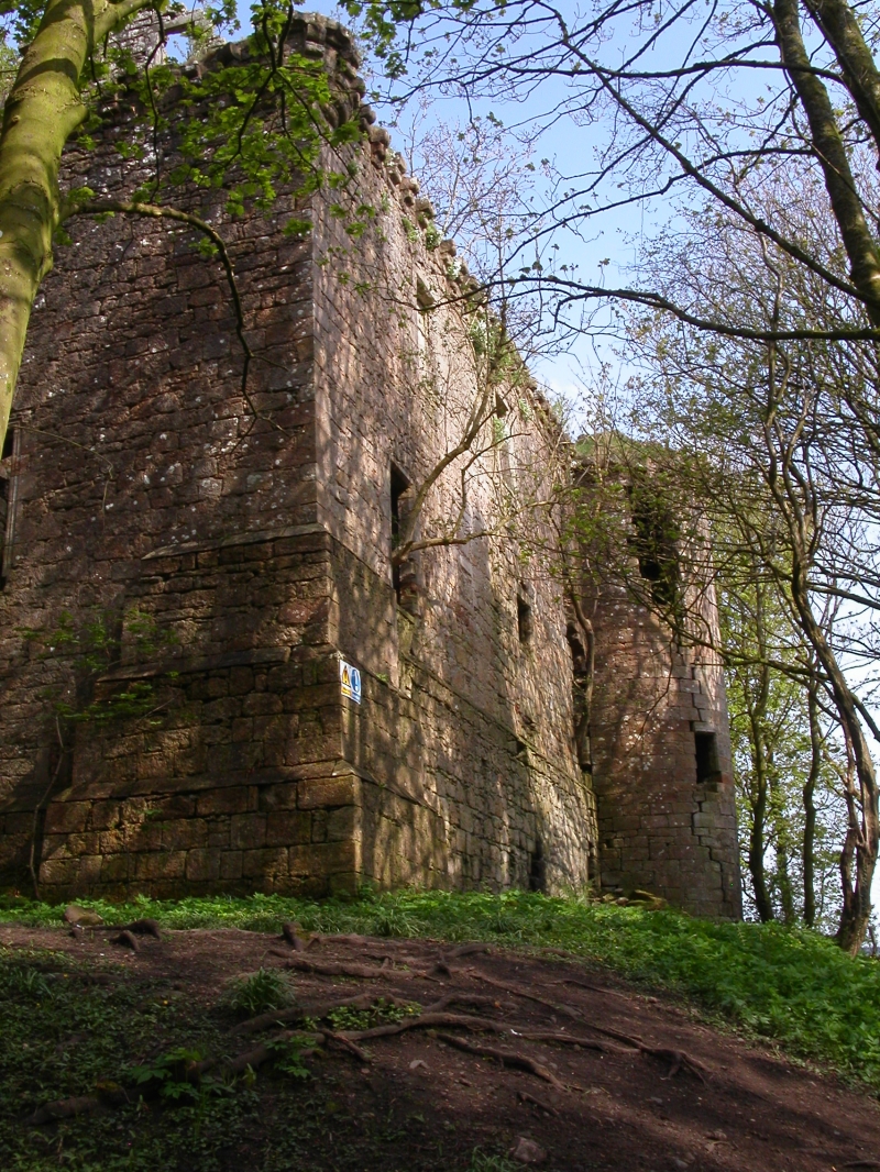
The old castle stands on the N bank of the Water of Girvan, c.300m SSE of the late 18th century castellated mansion (also called Dalquharran Castle), designed by Robert Adam. The old castle occupied a strong position, guarded by the Water of Girvan, marshlands, and a former moat. Originally a rectangular keep, the old castle was greatly enlarged and converted into a "stately castle" in about 1679.
The first recorded laird was Gilbert Kennedy, as recorded in 1474 in a charter of Crossraguel Abbey, following which the property was acquired by the Kennedys of Girvan Mains. Towards the end of the 17th century, Sir Thomas Kennedy of Kirkhill, Lord Provost of Edinburgh, purchased the estate.
The 15th century keep, from its plan and careful detailing, is an exceptional example of a castellated house. It was laid out on a rectangular plan comprising three storeys and an attic, probably with an external stair giving entrance to the great hall at first floor level. This floor was probably divided in two, with a private chamber at the E end giving access to the SE corner tower. This chamber contains an ornate aumbry, decorated with the arms of the Kennedys. A heavy buttress at the SW corner and a rectangular stair tower at the NW appear to have been secondary additions. The original castle measures 18m by 9m with walls almost 2m thick. The garret storey within the parapet walk is now lost. The ground floor is vaulted.
The large extension which transformed the N front has a pediment dated 1679, while a window lintel is dated 1677. This wing measures about 16.60m in length by 7m in width, with a projecting round tower at the NE angle, and a square tower in the re-entrant angle, articulated with both the old keep and with the new work. This new wing contained a kitchen and storage in the basement, with a large drawing-room on the first floor with bedrooms above. The N and W was enclosed by a barmkin wall, the central N part of which features the remarkable remains of an ornate 17th century gateway, linked to the 18th century mansion by a tree-lined avenue.
There are indications that the grounds were laid out with gardens, bowling greens, and other ornamental devices of the period. A scarp to the W of the main tower may represent the line of an enclosing moat, mentioned by MacGibbon and Ross.
The area proposed for scheduling comprises the remains described and an area around them within which related material may be expected to survive. The area is irregular in plan with maximum dimensions of 129m N-S by 126m E-W, as marked in red on the accompanying map. The modern fences are excluded from the scheduling. The surface of the modern paths are excluded to a depth of 300mm.
Source: Historic Environment Scotland
The monument is of national importance as the well preserved remains of a castellated residence, which has the potential to enhance our understanding of the development of the lordly house, from medieval castle to Renaissance mansion, evinced by the triumph of comfort and display over defence. The immediate surrounding area has the potential to provide important archaeological information regarding the infrastructure of such residences, notably the remains of formal gardens.
Source: Historic Environment Scotland
Bibliography
The monument is recorded by RCAHMS as NS 20 SE 9.
References:
Grose, F. (1789-91) The antiquities of Scotland, 2v, London, Vol. 2, 198.
MacGibbon and Ross, D and T (1887-92) The castellated and domestic architecture of Scotland from the twelfth to the eighteenth centuries, 5v, Edinburgh, Vol. 3, 344-8.
RCAHMS (1983 a) The Royal Commission on the Ancient and Historic
Monument of Scotland. The archaeological sites and monuments of North Carrick, Kyle and Carrick District, Strathclyde Region. The archaeological sites and monuments of Scotland series no 17, Edinburgh, 24, No. 165.
Source: Historic Environment Scotland
Other nearby scheduled monuments