Approximate Location Map
Large Map »
This site is entirely user-supported. See how you can help.
Latitude: 55.2562 / 55°15'22"N
Longitude: -4.7939 / 4°47'37"W
OS Eastings: 222538
OS Northings: 599336
OS Grid: NX225993
Mapcode National: GBR 43.BSKR
Mapcode Global: WH2QS.B4GW
Entry Name: Old Dailly Church
Scheduled Date: 3 March 1999
Source: Historic Environment Scotland
Source ID: SM8138
Schedule Class: Cultural
Category: Ecclesiastical: church; Secular: monument
Location: Dailly
County: South Ayrshire
Electoral Ward: Girvan and South Carrick
Traditional County: Ayrshire
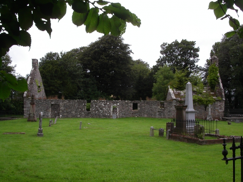
The monument comprises the remains of Old Dailly Parish Church and the surrounding graveyard: the latter contains several Covenanters' graves.
The building is of 17th-century date, although a built-up round-arched doorway in the N wall of the modern mausoleum which lies within the E end of the church indicates the existence of a pre-Reformation structure on the site. A church, dedicated to St Michael, is on record as being granted by the first Earl of Carrick to the Cluniac house at Paisley in 1236 and may be the precursor to the existing building. The church is rubble-built save for the outer face of the E gable which is constructed of ashlar sandstone. Both gable walls stand to full height and each is topped by a belfry: that on the E gable is the more ornamental of the two. The stone burial vault of the Dalrymple Hamilton family of Bargany occupies the E end of the ruined church whilst the single-storey, slate-roofed crypt of the Cathcarts of Killochan adjoins the church at the NE. The church was abandoned in 1696 in favour of a new church at Dailly. A monument in the churchyard, erected in 1835, marks the site of the graves of several Covenanters who were shot in the vicinity in 1685.
The area to be scheduled is irregular on plan with maximum dimensions of 65m NW-SE by 60m NE-SW to include the church and graveyard. The boundary of the scheduled area is defined by the surrounding graveyard wall which is also included in this scheduling. All burial lairs with existing burial rights are excluded.
Source: Historic Environment Scotland
Bibliography
No Bibliography entries for this designation
Source: Historic Environment Scotland
Other nearby scheduled monuments