Approximate Location Map
Large Map »
This site is entirely user-supported. See how you can help.
Latitude: 55.5962 / 55°35'46"N
Longitude: -2.4309 / 2°25'51"W
OS Eastings: 372941
OS Northings: 633708
OS Grid: NT729337
Mapcode National: GBR C3GQ.HQ
Mapcode Global: WH8XZ.MLMQ
Entry Name: Kelso Abbey
Scheduled Date: 13 February 1996
Source: Historic Environment Scotland
Source ID: SM90177
Schedule Class: Cultural
Category: Ecclesiastical: abbey
Location: Kelso
County: Scottish Borders
Electoral Ward: Kelso and District
Traditional County: Roxburghshire
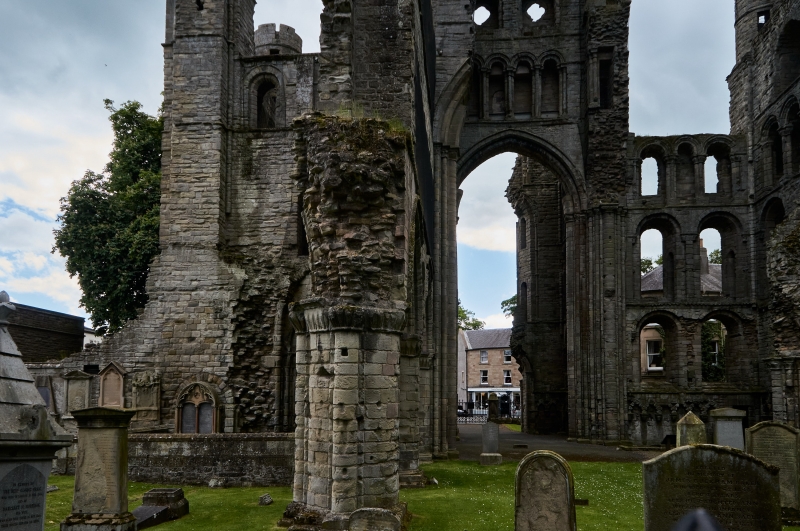
This monument is the remains of one of the series of abbeys founded by David I in the early twelfth century. It was a Tironesian house which was well endowed and, being so close to Roxburgh, had close royal connections. James III was crowned here.
The upstanding remains of the abbey are the west end of the church which is unusual in Scotland in having a western transept. The abbey church was finished in 1243. The remains show a vigorous use of rising arcades, both blind and open, to enliven the high towers. Two arches of the south nave arcade still stand as does the outer parlour and a trefoil doorway now built into the neighbouring monument to the Dukes of Roxburghe.
A monastery of this importance would have covered a large area and excavations in the 1970's revealed part of the south east transept and an infirmary range further east. Doubtless other remains survive elsewhere in the vicinity.
The area to be scheduled is bounded to the south by the River Tweed, to the west by Bridge Street, to the north by the church yard of Kelso Old Parish Church and to the east by Glebe Lane. Principal exclusions to the scheduling are all post-monastic stuctures above the ground which are not in the care of the Secretary of State for Scotland and all plots of ground where burial rights exist. The area measures a maximum of 300m N-S by 220m and is marked in red on the accompanying map.
Source: Historic Environment Scotland
Bibliography
No Bibliography entries for this designation
Historic Environment Scotland Properties
Kelso Abbey
https://www.historicenvironment.scot/visit-a-place/places/kelso-abbey
Find out more
Related Designations
BRIDGE STREET KELSO ABBEYLB35734
Designation TypeListed Building (A)StatusRemoved
Source: Historic Environment Scotland
Other nearby scheduled monuments