Approximate Location Map
Large Map »
This site is entirely user-supported. See how you can help.
Latitude: 54.8056 / 54°48'20"N
Longitude: -4.6801 / 4°40'48"W
OS Eastings: 227844
OS Northings: 548927
OS Grid: NX278489
Mapcode National: GBR GJT0.90P
Mapcode Global: WH2SZ.2GNT
Entry Name: Chapel Finian, chapel, enclosure and well
Scheduled Date: 30 November 1981
Last Amended: 2 December 1999
Source: Historic Environment Scotland
Source ID: SM90071
Schedule Class: Cultural
Category: Ecclesiastical: chapel
Location: Mochrum
County: Dumfries and Galloway
Electoral Ward: Mid Galloway and Wigtown West
Traditional County: Wigtownshire
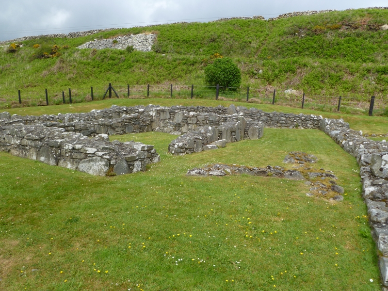
The monument consists of a small 10th- or 11th-century chapel within a stone-walled enclosure, close to the shore on the raised beach at Corwall Port.
The foundations of this small rectangular chapel, 6.7m by 4.1m internally, are oriented E-W. It has a S doorway and there are three buttresses on each of the side-walls, one in the centre and one against each corner. Excavation in 1950 revealed evidence of a stone bench, possibly encased in wood, set against the S part of the inner face of the E wall. The masonry is mortared and includes large upright stones set on edge to form foundation-courses and door-jambs. The building is tightly enclosed within the footings of a drystone boundary wall, and a stone-lined well lies to the SW, partly under the road-side dyke.
The area to be scheduled measures a maximum of 40m NW-SE by 25m SW-NE and includes the chapel, its enclosure, the well and an area to the SE likely to contain archaeological evidence for a priest's house and a graveyard. It is marked in red on the accompanying map.
Source: Historic Environment Scotland
Bibliography
No Bibliography entries for this designation
Historic Environment Scotland Properties
Chapel Finian
https://www.historicenvironment.scot/visit-a-place/places/chapel-finian
Find out more
Source: Historic Environment Scotland
Other nearby scheduled monuments