Approximate Location Map
Large Map »
This site is entirely user-supported. See how you can help.
Latitude: 56.3166 / 56°18'59"N
Longitude: -6.2533 / 6°15'11"W
OS Eastings: 137087
OS Northings: 721934
OS Grid: NM370219
Mapcode National: GBR BDY0.NJC
Mapcode Global: WGYD9.XHDF
Entry Name: Suidhe, depopulated township
Scheduled Date: 20 January 2004
Source: Historic Environment Scotland
Source ID: SM10661
Schedule Class: Cultural
Category: Secular: settlement, including deserted, depopulated and townships
Location: Kilfinichen and Kilvickeon
County: Argyll and Bute
Electoral Ward: Oban South and the Isles
Traditional County: Argyllshire
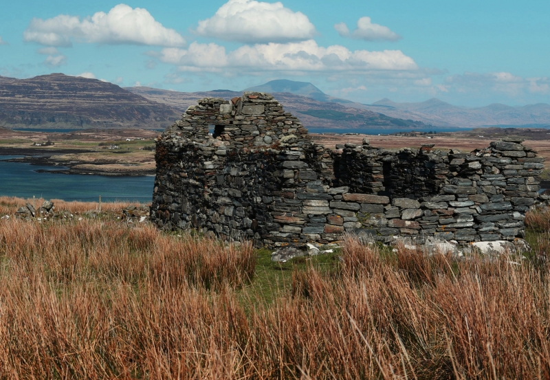
The monument comprises a depopulated township of medieval and later date, visible as upstanding remains.
The township is situated on the Ross of Mull, about 1200m WNW of Bunessan and 350m S of the southern shore of Loch na Lathaich, at about 50m OD. The settlement site, which slopes downwards slightly towards the loch, has extensive views over the loch and surrounding countryside.
A settlement is known to have existed in this location from at least 1654, when Blaeu's map depicted the site of 'Suy'. By 1881, the Ordnance Survey First Edition map depicted one unroofed building, five roofed buildings, one enclosure and a head dyke. Five unroofed buildings, one enclosure and the head dyke are shown on the current edition of the OS 1:10000 map (1976). The township had been completely abandoned by the 1940s.
A survey in 1991 confirmed that the pre-crofting township includes houses of drystone and of mortared construction. Several structures showed evidence of more than one period of use, such as blocked doors and windows. This impression is reinforced by the differential preservation of the structures, some surviving to gable height, and others much more reduced. Several houses also showed evidence of either a lean-to outbuilding or of an earlier structure at one gable end. Other structures had round gables and one had rounded lower courses corbelled out to a square from about 1m above foundation level. The different character of the buildings results from the different functions they served; one building in particular seems to represent a more prestigious dwelling. Field banks, built of stone-and-turf or turf alone, denoting agricultural divisions and also probably indicating more than one period of construction, were traced radiating away from the settlement. A stack field with boundary wall still in place is located immediately S of the settlement.
The area proposed for scheduling comprises the remains described and an area around them within which related material is likely to survive. It is an irregular polygon in shape, with maximum dimensions of 101m N-S by 104m E-W (115m WSW-ENE), as marked in red on the accompanying map.
Source: Historic Environment Scotland
The monument is of national importance because of its potential to contribute to an understanding of post-medieval, and possibly medieval, settlement and economy. Its importance is increased by the cartographic and survey evidence that this site was occupied and adapted over a period of at least several hundred years.
Source: Historic Environment Scotland
Bibliography
The monument is recorded by RCAHMS as NM32SE 18.
References:
Gray I and Gilfillan E 1990, 'Cnoc an t-suidhe (Bunessan parish), cairn, fieldbanks, settlement', DISCOVERY EXCAV SCOT, 32.
Gray I and Gilfillan E 1991, 'Cnoc an t-suidhe, Mull (Kilfinichen & Kilvickeon parish): cairn, fieldbanks, settlement', DISCOVERY EXCAV SCOT, 52.
Map references:
Blaeu, J 1654 Mula Insula, quae ex Aebudarum numero una est, et Lochabriae ad occasum praetenditur. The Yle of Mul which is one of the Westerne Yles, and lyeth ovir against Lochabyr / Auct. Timothy Pont.
Ordnance Survey 1881 First Edition Map (Argyllshire), sheet cxvii, 6 inches to 1 mile.
Source: Historic Environment Scotland
Other nearby scheduled monuments