Approximate Location Map
Large Map »
This site is entirely user-supported. See how you can help.
Latitude: 55.7744 / 55°46'27"N
Longitude: -3.6363 / 3°38'10"W
OS Eastings: 297454
OS Northings: 654659
OS Grid: NS974546
Mapcode National: GBR 311N.KW
Mapcode Global: WH5S7.34P4
Entry Name: Haywood, deserted mining village
Scheduled Date: 26 November 2001
Source: Historic Environment Scotland
Source ID: SM9684
Schedule Class: Cultural
Category: Industrial: coal
Location: Carnwath
County: South Lanarkshire
Electoral Ward: Clydesdale North
Traditional County: Lanarkshire
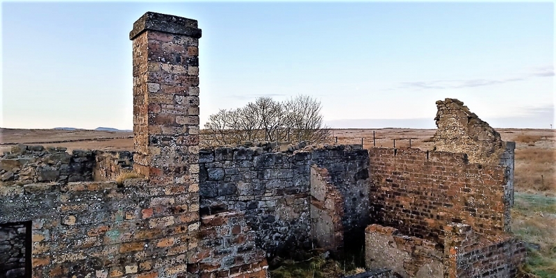
The monument comprises the remains of the deserted colliery village of Haywood, dating from the mid nineteenth century.
The monument is situated in rough pasture at between 255-265m O.D. on the N end of a ridge to the S of the Wilsontown Branch of the Caledonian Railway. It consists of a number of rows of miner's houses, a hotel and public house, a village hall, a Post Office, a Police Station and other ancillary buildings, centred at NS 974 546, visible as upstanding remains and low earthworks.
The areas proposed for scheduling comprises the remains described and an area around them within which related material may be expected to be found. The area is irregular in plan with maximum dimensions of 360m N-S by 320m E-W, as marked in red on the accompanying map extract. The cottage and associated land at Pentland View has been excluded from the scheduling.
Source: Historic Environment Scotland
The monument is of national importance as the remains of a now deserted 19th century colliery village, which has the potential to provide important information regarding contemporary social life. It represents an important and rare example of community development associated with the Lanarkshire coalfields which came to dominate the Scottish coal industry in the 19th century. The importance of the site is increased by its group value, by its rarity and by its historical significance.
Source: Historic Environment Scotland
Bibliography
RCAHMS records the monument as NS 95 SE 31.00 and NS 95 SE 31.02.
Aerial Photographs used:
RCAHMS (1995) C41145.
RCAHMS (1995) C41150.
Bibliography:
Giles, A. (comp)(1912) The county directory of Scotland containing the postal addresses of mansions, farms and other rural residences in Scotland, their occupants'.., Edinburgh, 1136.
Groome, F. H. (ed.) (1882-5) Ordnance gazetteer of Scotland: a survey of Scottish topography, statistical, biographical and historical, 6v, Edinburgh.
ONB, Ordnance Name Book (Lanarkshire) Book no. 12, 27.
RCAHMS (1998) Royal Commission on the Ancient and Historical Monuments of Scotland, Forts, Farms and Furnaces. Archaeology in the Central Scotland Forest.' Edinburgh.
TSA (1960) The third statistical account of Scotland: the county of Lanark, Thomson, G. (ed.), Glasgow, 554.
Source: Historic Environment Scotland
Other nearby scheduled monuments