Approximate Location Map
Large Map »
This site is entirely user-supported. See how you can help.
Latitude: 54.9298 / 54°55'47"N
Longitude: -5.0984 / 5°5'54"W
OS Eastings: 201576
OS Northings: 563856
OS Grid: NX015638
Mapcode National: GBR FHSP.3DY
Mapcode Global: WH1R1.NCC2
Entry Name: Leswalt, Old Parish Church
Scheduled Date: 5 March 1999
Source: Historic Environment Scotland
Source ID: SM7875
Schedule Class: Cultural
Category: Ecclesiastical: church
Location: Leswalt
County: Dumfries and Galloway
Electoral Ward: Stranraer and the Rhins
Traditional County: Wigtownshire
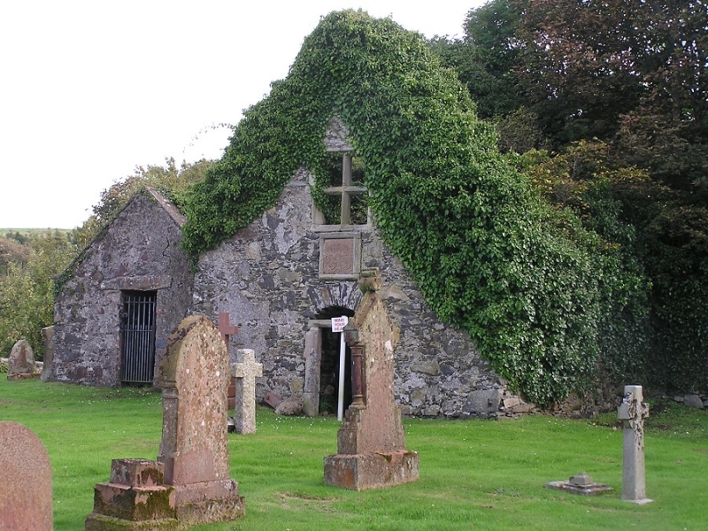
The monument comprises the roofless remains of Leswalt Old Parish Church and the adjacent building.
The Parish Church of Leswalt is recorded as being annexed to Tongland Abbey between 1355 and 1359,the site being abandoned and the existing building converted to secular use as the Parish School in 1828. The nave incorporates a fireplace in its E wall which dates from the latter period. At the SE corner of the nave lies a small vaulted chamber, presumably a burial vault. In the 17th century a wing was erected against the N wall of the nave. This was entered by a lintelled N-facing door over which is a window divided into four compartments by a moulded mullion and transom. Built for the Agnew family of
Lochnawe in 1644, this wing comprised the family burial vault on the ground floor with a laird's loft above. To the immediate E of the church stands a more modern building with a slate roof.
The area to be scheduled is a rectangle 30m E-W by 25m transversely to include the church, its interior, the burial chamber and the more modern building and an area of ground
extending 5m out from the outer walls on all sides, as marked in red on the accompanying map extract. Any lairs with existing burial rights are excluded from this scheduling.
Source: Historic Environment Scotland
Bibliography
No Bibliography entries for this designation
Source: Historic Environment Scotland
Other nearby scheduled monuments